
The Storm Prediction Center and National Weather Service have issued a tornado watch covering the Texas Panhandle, South Plains, and Rolling Plains. This watch is in effect until 10 PM. We have the first storm of the day firing up near Borger with additional storms near Turkey. This activity will move northeast – but we will start to see deviant motion to the east/southeast with intense supercells in the next few hours. The strongest storms could produce very large hail up to the size of a softball, damaging wind gusts to 70 MPH, and a couple tornadoes. The highest tornado threat will be with dominant right-moving supercells between 5 PM and 9 PM this evening. As a reminder we are chasing in the Panhandle and will be streaming live video soon here.
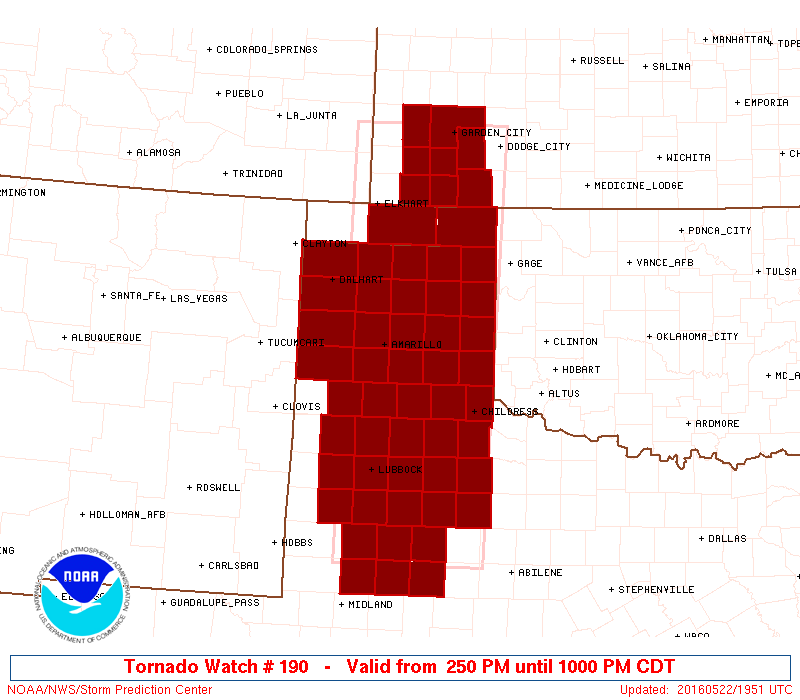
TORNADO WATCH NUMBER 190
   NWS STORM PREDICTION CENTER NORMAN OK
   250 PM CDT SUN MAY 22 2016

   THE NWS STORM PREDICTION CENTER HAS ISSUED A

   * TORNADO WATCH FOR PORTIONS OF
     SOUTHWEST KANSAS
     OKLAHOMA PANHANDLE
     WEST TEXAS INCLUDING THE PANHANDLE

   * EFFECTIVE THIS SUNDAY AFTERNOON AND EVENING FROM 250 PM UNTIL
     1000 PM CDT.

   * PRIMARY THREATS INCLUDE...
     A FEW TORNADOES POSSIBLE
     WIDESPREAD LARGE HAIL EXPECTED WITH ISOLATED VERY LARGE HAIL
       EVENTS TO 4 INCHES IN DIAMETER LIKELY
     SCATTERED DAMAGING WIND GUSTS TO 70 MPH POSSIBLE

   SUMMARY...ISOLATED SUPERCELL THUNDERSTORMS ARE EXPECTED TO FORM THIS
   AFTERNOON ALONG THE DRYLINE AND SPREAD ACROSS THE WATCH AREA.  VERY
   LARGE HAIL IS POSSIBLE WITH THESE STORMS...ALONG WITH A RISK OF
   DAMAGING WINDS AND A FEW TORNADOES.

   THE TORNADO WATCH AREA IS APPROXIMATELY ALONG AND 65 STATUTE
   MILES EAST AND WEST OF A LINE FROM 90 MILES SOUTH SOUTHEAST OF
   LUBBOCK TEXAS TO 20 MILES WEST NORTHWEST OF GARDEN CITY KANSAS.
   FOR A COMPLETE DEPICTION OF THE WATCH SEE THE ASSOCIATED WATCH
   OUTLINE UPDATE (WOUS64 KWNS WOU0).

   PRECAUTIONARY/PREPAREDNESS ACTIONS...

   REMEMBER...A TORNADO WATCH MEANS CONDITIONS ARE FAVORABLE FOR
   TORNADOES AND SEVERE THUNDERSTORMS IN AND CLOSE TO THE WATCH
   AREA. PERSONS IN THESE AREAS SHOULD BE ON THE LOOKOUT FOR
   THREATENING WEATHER CONDITIONS AND LISTEN FOR LATER STATEMENTS
   AND POSSIBLE WARNINGS.


0 Comments