
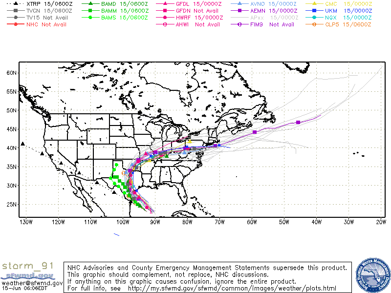
As of 2am this morning, invest 91 was upgraded to an 80% chance of tropical storm formation within the next 48 hours. While the system continues to look a bit unorganized, it’s remains likely that we will see tropical storm “Bill” by the end today or overnight tonight. The forecast track for the system still remains unclear and is highly dependent upon the strength and position of an upper level high building across the southeastern US at this time. Once the system makes landfall…currently estimated to be on Tuesday…it will ride along the western periphery of the high pressure ridge which means the location of the ridge at that time will be the determining factor. Some of the latest forecast models coming in are pushing the track just a bit further west from previous, which means the potential for the system to impact the I-35 corridor. Previous tracks took it mainly east of I-35 with heaviest impacts across southeast, east and northeast Texas. At any rate, ALL gulf coast residents…especially those from Corpus to Beaumont will need to carefully monitor this system and begin to prepare now for moderate to high-impact flooding along the coast and inland after the storm makes landfall. Please continue to check back for updates throughout the day!

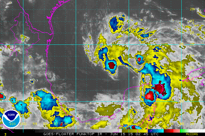
TROPICAL WEATHER OUTLOOK
NWS NATIONAL HURRICANE CENTER MIAMI FL
200 AM EDT MON JUN 15 2015

For the North Atlantic...Caribbean Sea and the Gulf of Mexico:

1. Surface observations and satellite data indicate that the broad
area of low pressure over the south-central Gulf of Mexico has
changed little over the past several hours.  The system's
circulation is not well-defined, and the associated shower and
thunderstorm activity remains disorganized.  The low continues to
produce tropical storm force winds well to the east and northeast of
the center.  Upper-level winds are forecast to gradually become more
favorable while this system moves northwestward during the next
day or two across the western Gulf of Mexico, and a tropical
depression or tropical storm could form during that time.  A
Hurricane Hunter aircraft is scheduled to investigate the system
later this morning.

Interests in and along the northwestern Gulf of Mexico should
monitor the progress of this system.  Regardless of tropical cyclone
formation, tropical storm conditions are possible along portions of
the middle and upper Texas coast and the western Louisiana coast
Monday night and Tuesday.  There is also a risk of heavy rainfall
and possible flooding across portions of eastern Texas and western
Louisiana.  For additional information, please see High Seas
Forecasts and products issued by your local National Weather Service
forecast office.
* Formation chance through 48 hours...high...80 percent
* Formation chance through 5 days...high...80 percent


0 Comments