
Thunderstorms have developed across eastern New Mexico over the past hour. These storms have become strong to severe. With a general movement to the east/northeast these storms will likely move into Texas later this morning. Some storms will likely be severe with a threat of large hail and damaging wind gusts. A tornado cannot be ruled out. Localized flooding is also possible as heavy rain will also occur with these storms. The Storm Prediction Center indicates a severe weather watch will likely be issued at some point this morning.
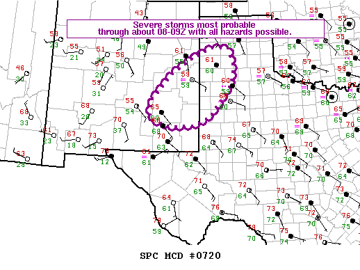
MESOSCALE DISCUSSION 0720
NWS STORM PREDICTION CENTER NORMAN OK
1235 AM CDT SAT MAY 23 2015
AREAS AFFECTED…ERN NM…WRN PANHANDLE/S PLAINS OF TX
CONCERNING…SEVERE POTENTIAL…WATCH POSSIBLE
VALID 230535Z – 230730Z
PROBABILITY OF WATCH ISSUANCE…60 PERCENT
SUMMARY…A FEW SEVERE STORMS ARE EXPECTED OVERNIGHT WITH LARGE HAIL
AS THE PRIMARY HAZARD…ALTHOUGH STRONG TO SEVERE WINDS AND A
TORNADO OR TWO ARE ALSO POSSIBLE /ESPECIALLY OVER SERN NM/.


0 Comments