
For the fifth time in about a week we’ll be dealing with another widespread winter storm in Texas. As usual a large area will be under the gun with a variety of impacts expected. For that reason we’ll divide this up into regions. For locations along and east of I-35 we expect most winter weather and impacts tonight versus this morning or this afternoon. We’ll see winter precipitation this morning in the Texas Panhandle moving south into the South Plains early this afternoon. We’ll see
Texas Panhandle
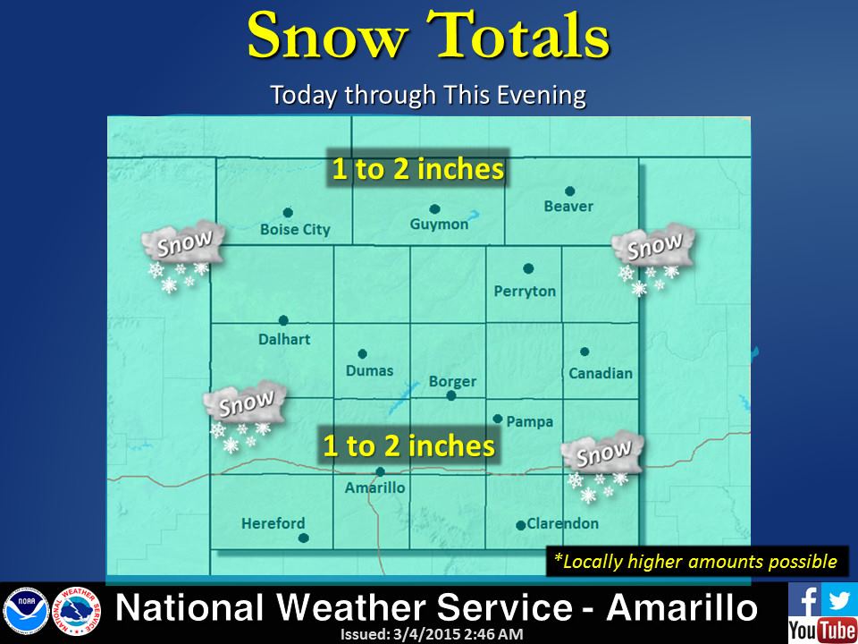
A Winter Weather/Travel Advisory is in effect through midnight for all of the Texas Panhandle. Light snow is possible today with snow accumulations up to two inches. The majority of the winter weather will pass south of the region. Some slick spots on roads will be possible but this will be a minor event for the Texas Panhandle.
… Winter Weather Advisory remains in effect until midnight CST
Wednesday night…
A Winter Weather Advisory for snow… sleet… and freezing drizzle remains
in effect until midnight CST Wednesday night.
* Event… a mix of light snow… freezing drizzle… and possibly sleet
is expected tonight. Light ice accumulations from freezing drizzle
will be possible. A transition to all snow is expected Wednesday morning
with total snow accumulations ranging from 1 to 2 inches. Locally
higher amounts will be possible.
* Timing… a mix of light snow… freezing drizzle… and possibly
sleet will continue tonight. Snow will become the dominant
precipitation type by late morning Wednesday. Snow will end
Wednesday evening.
* Impacts… roads and bridges will likely be snow packed and
icy… resulting in hazardous travel conditions. Areas of
blowing snow may reduce visibility at times.
Precautionary/preparedness actions…
A Winter Weather Advisory means that periods of snow… sleet… or
freezing rain will cause travel difficulties. Be prepared for
slippery roads and limited visibilities… and use caution while
driving.
South Plains in West Texas
A Winter Weather Advisory is in effect for the South Plains in West Texas until midnight tonight. Accumulating winter precipitation is expected to develop this morning and spread across the region this afternoon. Initial precipitation may fall as sleet before changing to all snow. Widespread snow accumulations of 1 to 2 inches will be possible. Slightly higher snow accumulations will be possible in the northern South Plains.
.. Winter Weather Advisory remains in effect from 3 am Wednesday
to midnight CST Wednesday night…
* timing… accumulations of wintry precipitation across the
southern Texas Panhandle and northern South Plains are expected
to begin Wednesday morning and spread southwestward during the
day.
* Main impact… light accumulations of ice from freezing rain and
or sleet will provide the initial wintry threat followed by
snowfall. Widespread snowfall amounts of one to two inches are
expected with locally higher amounts possible across the
northern South Plains and far southern Texas Panhandle.
* Other impacts… icy and snow covered roadways will result in
hazardous travel conditions. Furthermore… rather breezy north
winds will cause areas of blowing snow and restrict
visibilities. The cold air mass ushered in by the cold front
will drop wind chill values into the single digits from the far
southern Texas Panhandle into the central South Plains.
Precautionary/preparedness actions…
A Winter Weather Advisory means that periods of snow… sleet… or
freezing rain will cause travel difficulties. Be prepared for
slippery roads and limited visibilities… and use caution while
driving.
Permian Basin
A Winter Weather Advisory is in effect this afternoon through Thursday morning across all of the Permian Basin for up to an inch of snow and a glazing of ice which will cause roads to become hazardous later today.
… Winter Weather Advisory in effect from noon CST /11 am MST/
today to 6 am CST /5 am MST/ Thursday…
* event… freezing rain, sleet and snow.
* Timing… noon CST today until 6 am CST Thursday.
* Impacts… accumulating ice and snow may result in slick and
hazardous roadways… particularly bridges and overpasses.
* Snow accumulations… less than one inch to two inches.
* Ice accumulations… one tenth of an inch or less.
Precautionary/preparedness actions…
A Winter Weather Advisory means that periods of snow… sleet… or
freezing rain will cause travel difficulties. Be prepared for
slippery roads and limited visibilities… and use caution while
driving.
Big Country and Concho Valley
A Winter Weather Advisory is in effect beginning at noon for the Big Country and 3 PM for the Concho Valley. They will remain in effect through Thursday morning. Sleet and snow accumulations up to 2 inches will be possible across the Big Country. Locally higher amounts of sleet/snow will be possible in the eastern Big Country. A tenth of an inch of freezing rain (ice) accumulation and up to an inch of snow will be possible in the Concho Valley.
… Winter Weather Advisory now in effect from noon today to 6 am
CST Thursday…
The Winter Weather Advisory is now in effect from noon today to
6 am CST Thursday for the Big Country.
* Impacts: slick and hazardous roadways will create dangerous
driving conditions.
* Timing: noon today until 6 am CST Thursday.
* Accumulations: 1/10 inch of ice… with 1 to 2 inches of sleet
and snow.
Precautionary/preparedness actions…
A Winter Weather Advisory means that periods of snow… sleet… or
freezing rain will cause travel difficulties. Be prepared for
slippery roads and limited visibilities and use caution while
driving.
Northwest Texas
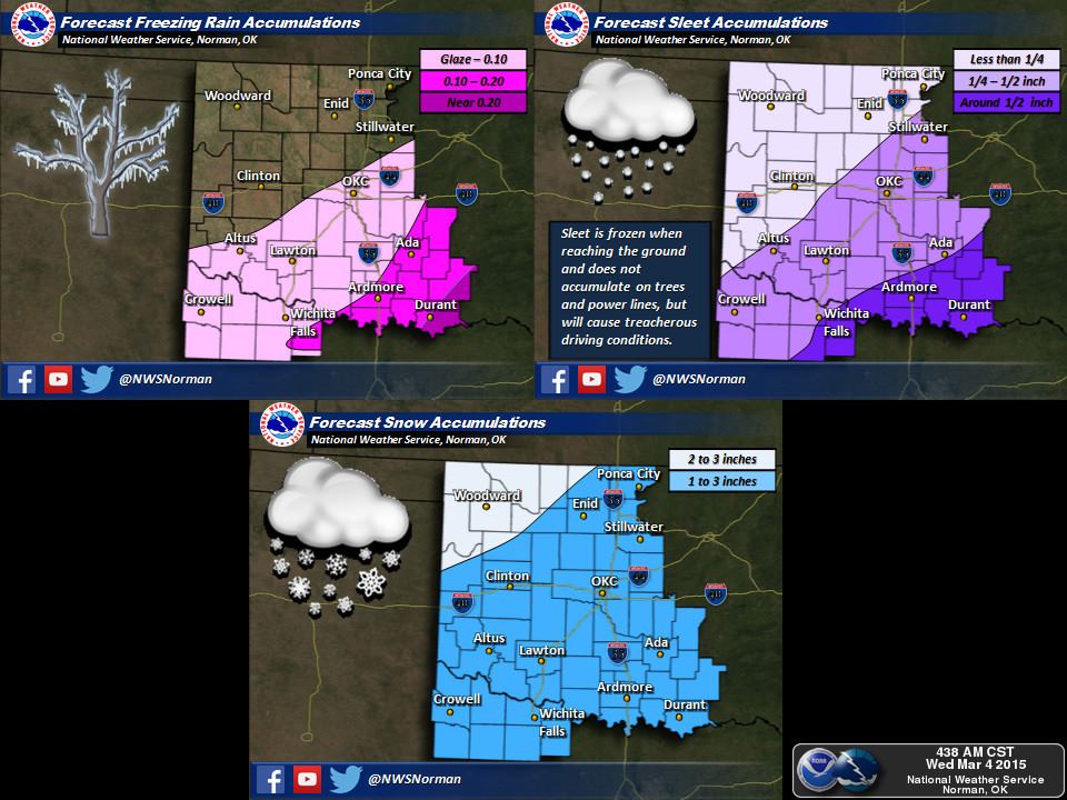
A Winter Weather Advisory is in effect through midnight tonight for all of Northwest Texas including Vernon and Wichita Falls. For the most part we expect sleet/ice accumulations of 0.10 to 0.20 inches with 2 to 4 inches of snow possible. Roads will become slick and hazardous this afternoon.
… Winter Weather Advisory remains in effect until midnight CST
tonight…
A Winter Weather Advisory remains in effect until midnight CST
tonight for parts of central and southern Oklahoma… and all of
western North Texas.
* Timing: accumulating sleet and freezing rain will be possible
this morning into the afternoon hours… except in parts of
south central and southeast Oklahoma when rain will transition
to freezing rain and sleet this afternoon. Otherwise… . the
freezing rain will transition to sleet and snow in the afternoon
and into the evening. The heaviest winter precipitation is
expected to occur between noon and 9 PM.
* Snow and sleet accumulations: sleet accumulations are expected
to be highest south and east of the Interstate-44 corridor
where some areas could see a half inch of sleet. Snow
accumulations of one to three inches are likely with isolated
heavier amounts.
* Ice accumulations: ice accumulations of a glaze to less than two
tenths of an inch will be possible… mainly along and southeast
of the I-44 corridor. The heaviest amounts are expected in parts
of south central and southeast Oklahoma.
* Main impact: slick and hazardous roadways are expected to
develop from accumulating sleet… snow… and ice.
* Other impact: with stronger winds expected south of
Interstate-40… decreased visibilities in blowing snow will
compound the travel dangers this afternoon and tonight.
Precautionary/preparedness actions…
Be careful if you have to travel. Even small amounts of ice and
snow can make roads and sidewalks slick and dangerous.
North Texas
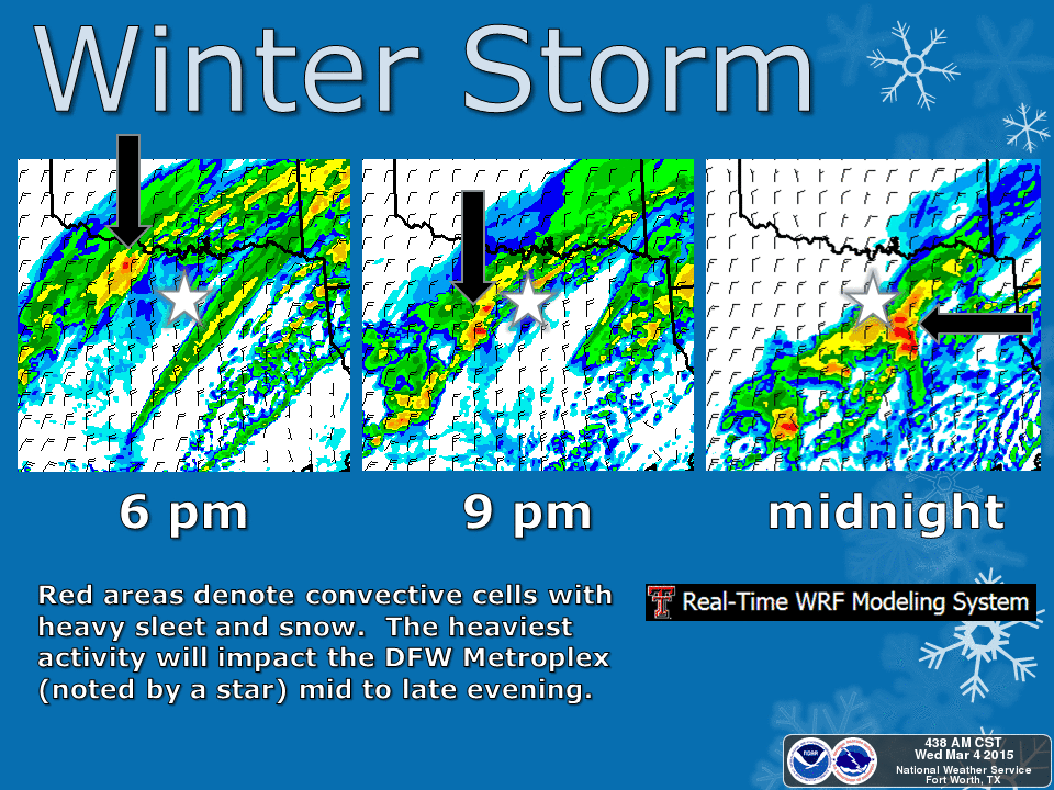
A Winter Storm Warning goes into effect at 3 PM this afternoon and continues through Thursday morning for the D/FW Metroplex and areas north of a Goldwaith to Canton line. This includes all of the D/FW Metroplex and points north to the Red River. Rain will be ongoing this morning into the early afternoon hours. Temperatures will drop below freezing later this afternoon with the first significant wintry precipitation expected by early evening. Significant sleet and snow accumulations will be possible with treacherous road conditions tonight.

… Winter Storm Warning in effect from 3 PM this afternoon to
noon CST Thursday…
The National Weather Service in Fort Worth has issued a Winter
Storm Warning for freezing rain… sleet… and snow… which is in
effect from 3 PM this afternoon to noon CST Thursday. The Winter
Weather Advisory is no longer in effect.
* Timing… from 3 PM Wednesday through noon Thursday.
* Precipitation type… freezing rain… sleet… and snow.
* Accumulation… 1/10 to 1/4 inch of ice… then up to 3 inches of
sleet and snow possible.
* Temperatures… falling below freezing late afternoon to early
evening. Lows in the mid to upper 20s Wednesday night.
* Impacts… accumulating ice… sleet… and snow will create
hazardous travel conditions… beginning Wednesday evening and
continuing through Thursday morning.
Precautionary/preparedness actions…
Slow down and use caution while driving. Bridges and overpasses
will be the first places that icy spots will develop. Do not slam
on the brakes when approaching an icy bridge or overpass.
Instead… maintain a constant safe speed and coast across the ice.
If you start to slide or skid… calmly steer in the direction of
the skid to straighten the vehicle out and regain control.
Central Texas
A Winter Weather Advisory goes into effect at midnight for areas north of a Lampasas to Temple and Palestine line. Freezing rain accumulations up to a tenth of an inch with sleet accumulations up to half an inch possible in some locations. Slick spots on roads and bridges will be a good bet by Thursday Morning. A Winter Storm Warning/Winter Weather Advisory is expected to be issued for the remainder of Central Texas including the Austin/San Antonio areas this afternoon.
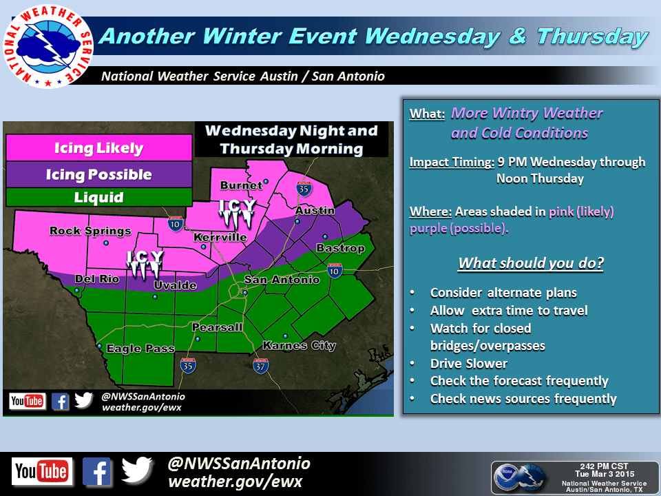
… Winter Weather Advisory remains in effect from midnight
tonight to noon CST Thursday…
* timing… midnight Wednesday night through noon Thursday.
* Precipitation type… freezing rain… transitioning to sleet and
snow.
* Accumulation… around 1/10 of an inch of ice… then less than
one inch of sleet and snow possible.
* Temperatures… falling below freezing after midnight tonight.
* Impacts… accumulating ice… sleet… and snow will create
hazardous travel conditions… beginning late Wednesday night and
continuing through Thursday morning.
Precautionary/preparedness actions…
Bridges and overpasses will be the first locations where icy spots
may develop. Please travel with caution.
Northeast Texas
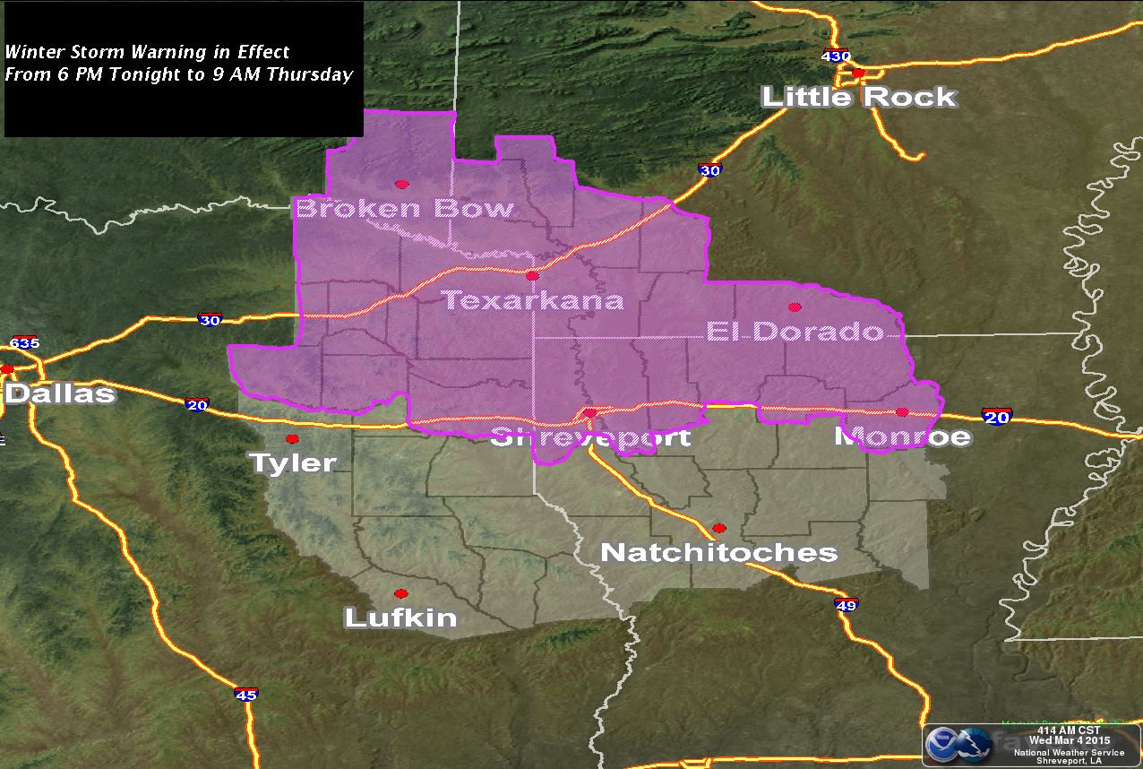
A Winter Storm Warning is in effect tonight for Northeast Texas with a Winter Weather/Travel Advisory for locations in East Texas. Freezing rain and sleet accumulations up to a quarter inch will be possible with up to an inch of snow. Slick and hazardous road conditions are likely. A Winter Weather Advisory
… Winter Storm Warning in effect from 6 PM this evening to 9 am
CST Thursday…
The National Weather Service in Shreveport has issued a Winter
Storm Warning for freezing rain and sleet… which is in effect from 6
PM this evening to 9 am CST Thursday. The Winter Storm Watch is no
longer in effect.
* Event… rain will transition to freezing rain and eventually to
sleet and snow as cold air on the surface and aloft spreads
over the area.
* Timing… winter precipitation in the form of freezing rain is
expected during the evening hours followed by a transition to
sleet and then snow after midnight.
* Impact… freezing rain and sleet accumulations of up to a
quarter of an inch and snow accumulations of around one inch
will make driving conditions hazardous.
Precautionary/preparedness actions…
A Winter Storm Warning means significant amounts of snow…
sleet… and ice are expected or occurring. Strong winds are also
possible. This will make travel very hazardous or impossible.
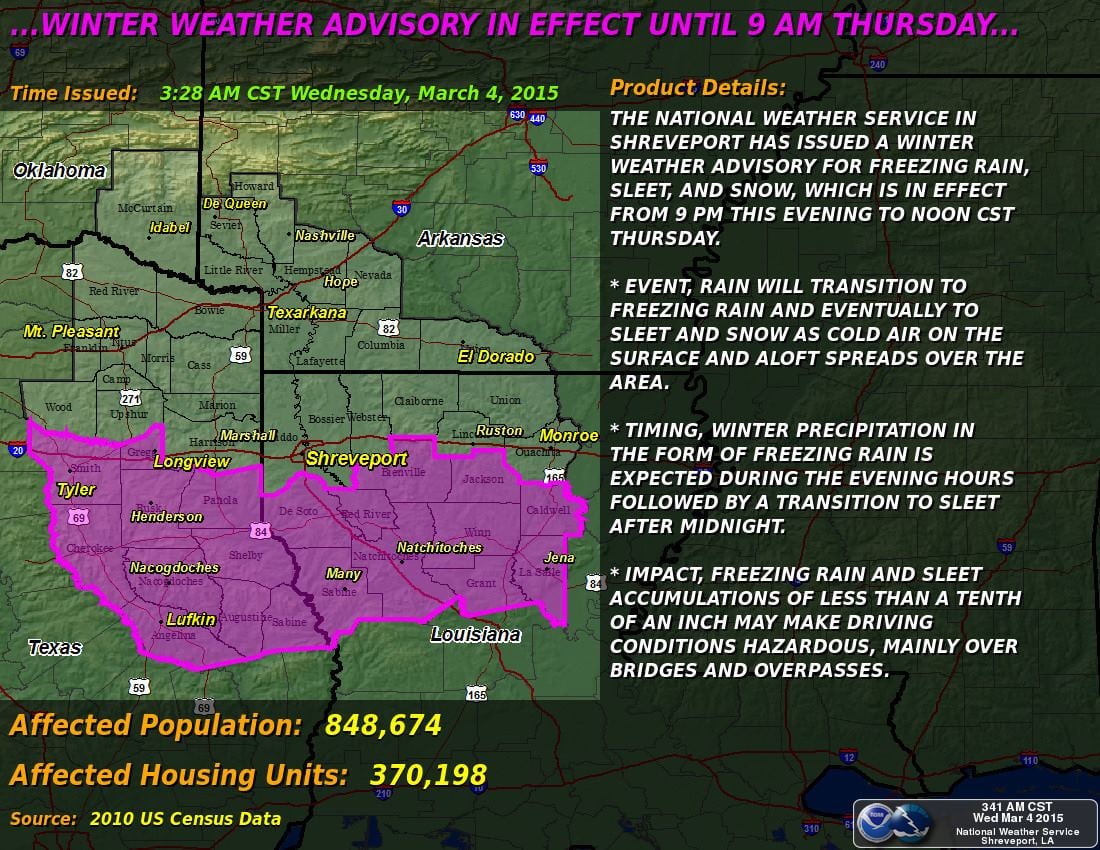
… Winter Weather Advisory in effect from 9 PM this evening to
noon CST Thursday…
The National Weather Service in Shreveport has issued a Winter
Weather Advisory for freezing rain… sleet… and snow… which is
in effect from 9 PM this evening to noon CST Thursday.
* Event… rain will transition to freezing rain and eventually to
sleet and snow as cold air on the surface and aloft spreads over
the area.
* Timing… winter precipitation in the form of freezing rain is
expected during the evening hours followed by a transition to
sleet after midnight.
* Impact… freezing rain and sleet accumulations of less than a
tenth of an inch may make driving conditions hazardous… mainly
over bridges and overpasses.
Precautionary/preparedness actions…
A Winter Weather Advisory means that periods of sleet or freezing
rain will cause travel difficulties. Be prepared for slippery
roads and limited visibilities… and use caution while driving.


0 Comments