
We have one more comparatively quiet weather day before Mother Nature throws us a fall severe weather event. It won’t take a meteorologist to notice it feels more like April than November across Texas. Oppressive humidity indicates that moisture is back ahead of our upcoming storm system.
For a quick run-down of the forecast, including threats, timing, and a few possible scenarios, I encourage folks to watch today’s Texas Weather Roundup video. I’ve embedded the video into this article. Nevertheless, I’ll do my best to convey the forecast old-school for those who prefer to read.
Texas Panhandle (Tonight)
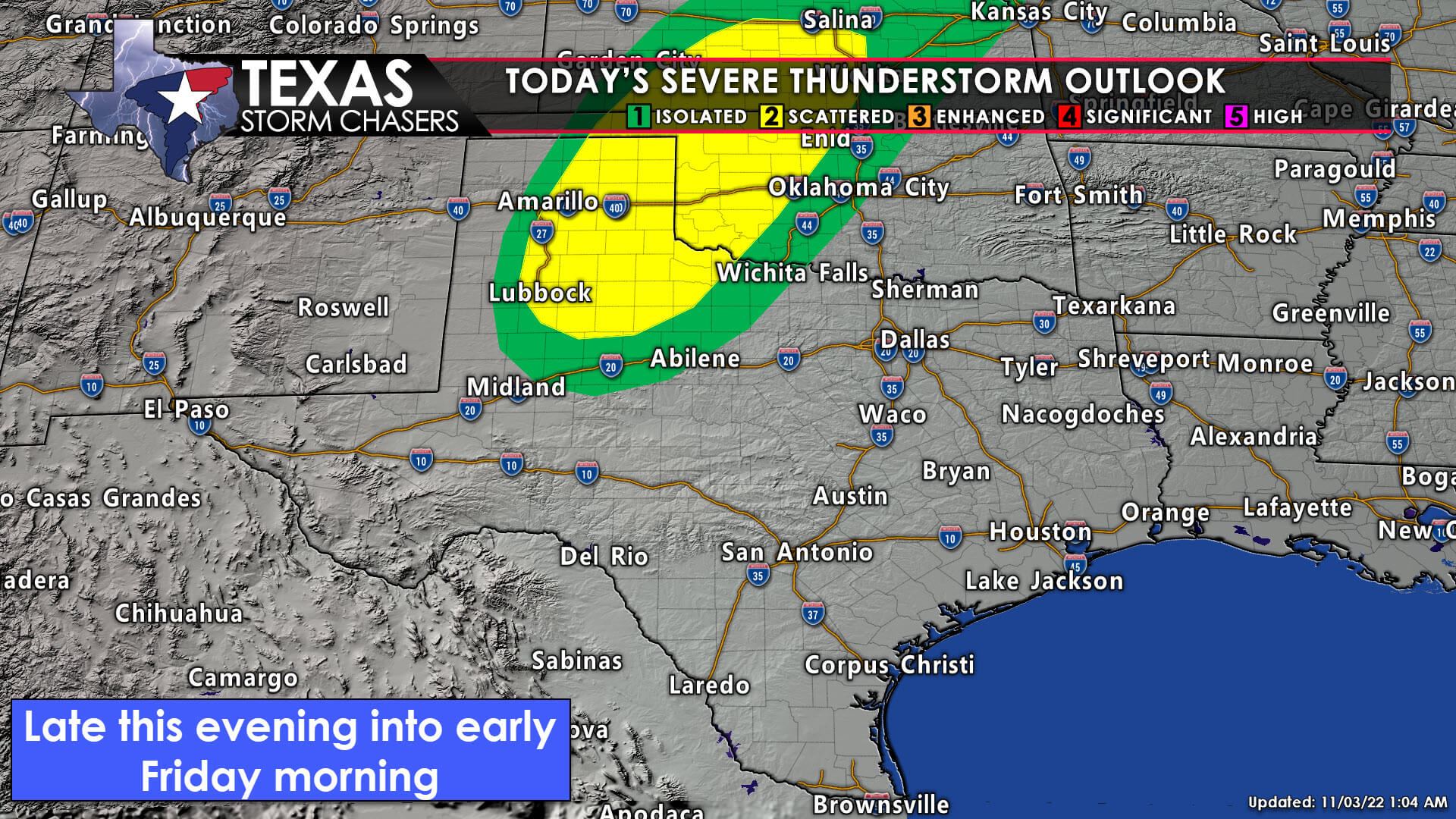
We can have an isolated severe storm in the Texas Panhandle this evening, with a better chance for storms after midnight. If any surface-based storms fire in the Panhandle between dinner and 10 PM, that storm may become rowdy with all modes of severe weather. Call it a low-probability, high-impact scenario. It probably won’t happen, but if it does, said storm would probably be throwing out baseballs and dropping tornadoes.
What is more likely is that we’ll have to wait until closer to midnight for scattered showers and storms to develop in the Texas Panhandle. Some storms may produce large hail and gusty winds but with a much lower tornado threat. Storm motions will have storms flying northeast toward Kansas and Oklahoma. We may see showers and storms continue through sunrise.
Friday (Eastern half of Texas)
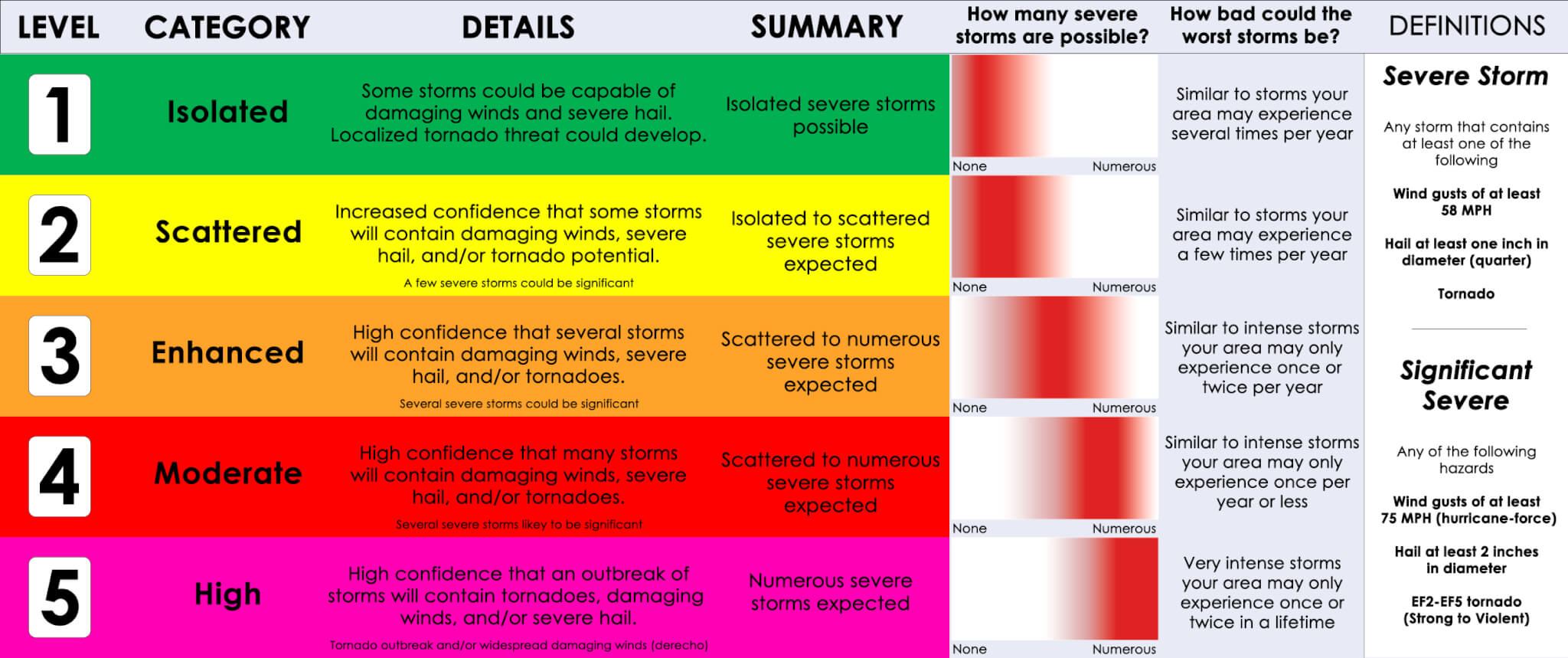
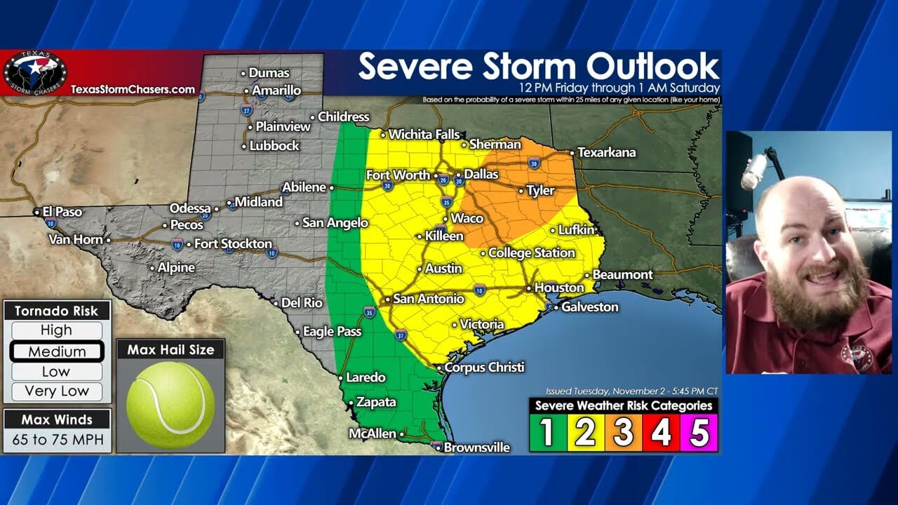
Before I dive into tomorrow’s severe weather threat, I wanted to share a graphic explaining the severe weather outlooks – and what we hope to convey with each ‘risk level.’ I know they can be more confusing than a five-way stop in gridlock traffic, but hopefully, I can help clear the air.
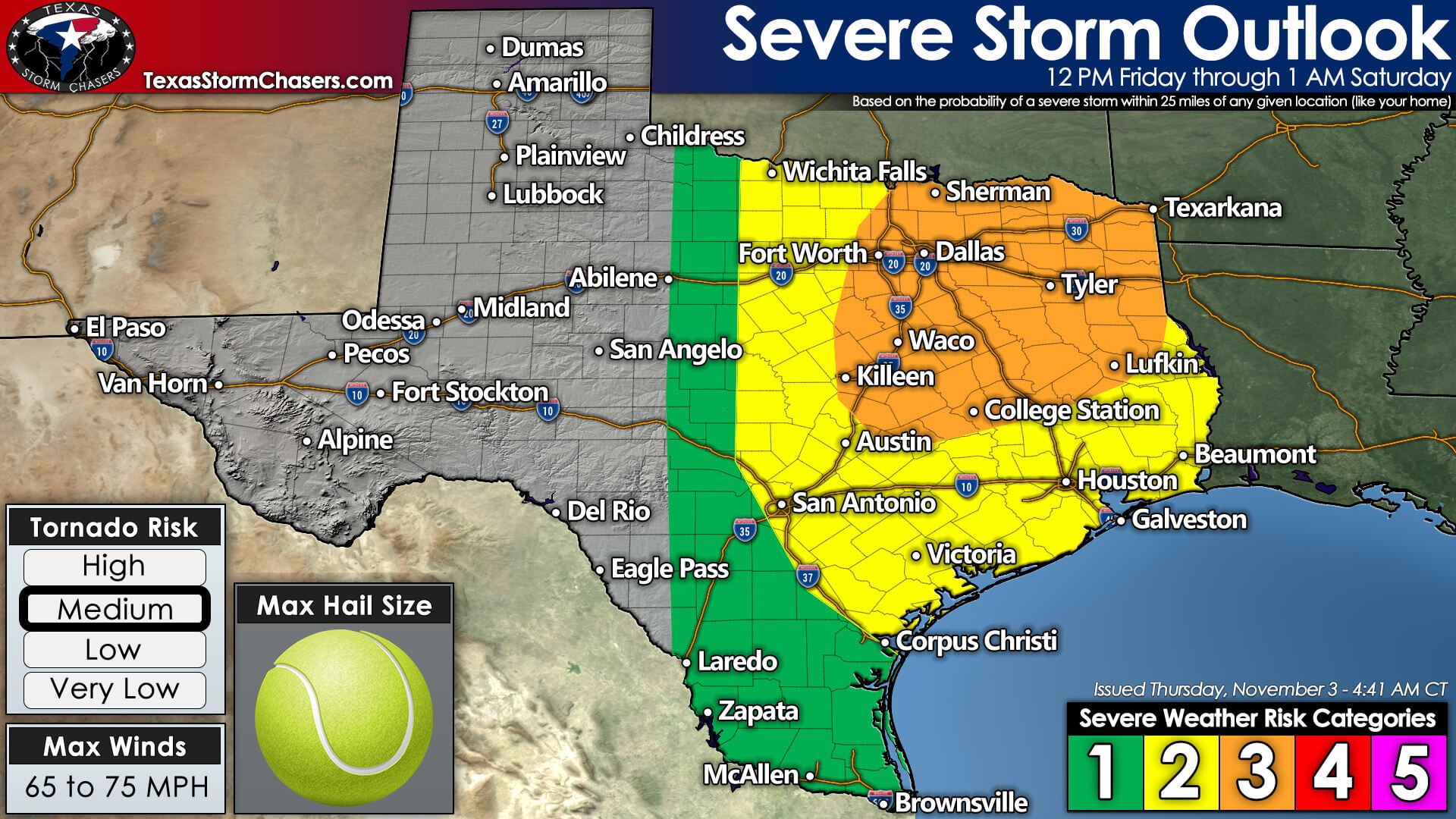
Severe thunderstorms are likely Friday afternoon and Friday evening across the eastern third to the east half of Texas. The Storm Prediction Center has placed a level 3 (out of 5) risk for severe storms across eastern North Texas, Northeast Texas, and East Texas back into the Brazos Valley. A level 2 (out of 5) risk for severe storms across Northwest Texas, western North Texas, the Hill Country, Central Texas, down into the Victoria Crossroads, Coastal Plains, Southeast Texas, and the Golden Triangle. A level 1 (out of 5) risk for severe storms includes the Rio Grande Valley. We’ll discuss specific threats and timing below, but we’re generally anticipating all modes of severe weather on Friday. Damaging straight-line winds, tornadoes, and some large hail. We may be off to the races as early as 12 PM-1 PM and may not have the severe storms exit Texas to the east, or move off the Upper Texas Coast, until about midnight Saturday.
There is an increased probability of tornadoes on Friday across the same regions that have a level 3 (out of 5) severe weather risk. A squall line will move east with damaging straight-line winds and spin-up tornadoes. However, there is a concern we may also have to deal with a round of more discrete, supercelluar storms before the squall line. If we have a round of supercells tomorrow afternoon, they will be in a favorable environment for rotation and severe weather. We could also have severe storms ongoing by early afternoon.
Timing
I encourage folks to watch the video posted above for a brief description of tomorrow’s timing, but I’ve included an animation of the simulated radar from one model run. The animation shows what may be a ‘further west’ solution, but it seems to mark an excellent middle ground between various weather model guidance.
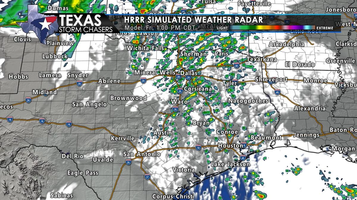
Simulated weather model radar for Friday. Things will probably be somewhat different, so don’t take it as the gospel.
As usual, we may see tomorrow’s ‘kick-off’ shift a bit west in future forecasts or maybe east. The HRRR model (shown above) does depict an initial round of supercell thunderstorms before firing off the squall line early tomorrow evening. Damaging straight-line winds and spin-up tornadoes will be the primary hazards with the strongest storms in the squall line.
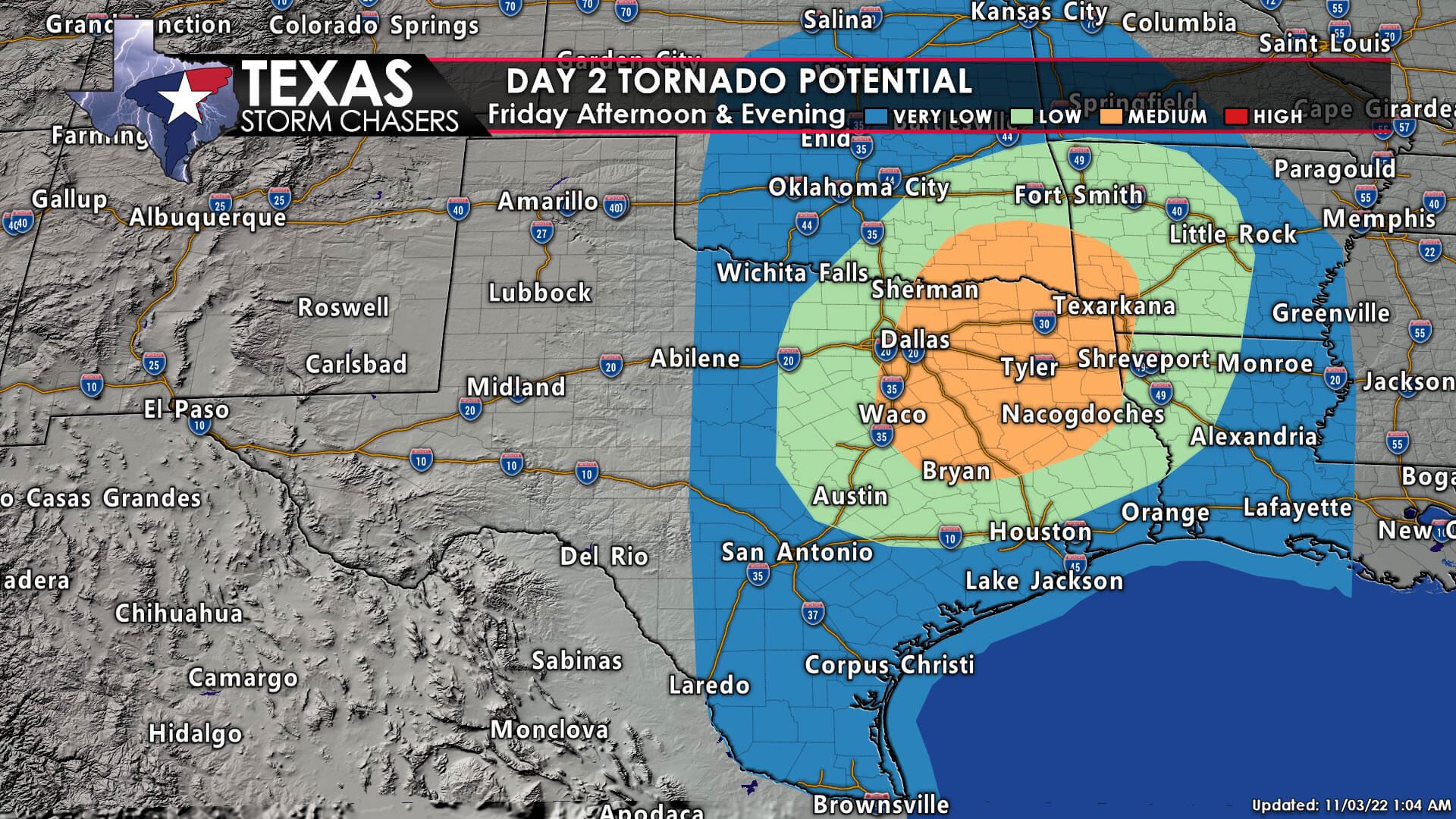
Discrete thunderstorms, ahead of the squall line, will potentially become supercellular and produce significant severe weather. The highest likelihood for discrete storms will be from 1 PM Friday in North/Central Texas and the Brazos Valley to about 7 PM in eastern North Texas, Northeast Texas, and East Texas. If we see breaks in the clouds tomorrow, that’ll add more jet fuel to a volatile severe weather setup and increase the chance for ‘discrete storms’ ahead of (or before) the squall line.
Once the squall line fires up late tomorrow afternoon, it’ll make steady but quick progress to the east/southeast. It should be moving into Arkansas and Louisiana by mid-evening and off the Upper Texas Coast around midnight. Spotty storms, some strong, may continue further southwest in South Texas, but the overall severe weather threat will be lower tomorrow night due to the upper-level storm system moving away.
Notes & Our Plans
Given the potential for stormy mischief on Friday, we encourage folks to have multiple ways to receive weather warnings. I’ll be ‘live’ with severe weather coverage tomorrow, and that live video will be directly embedded on our website and within our free mobile app. We’ll also be streaming live video on most of our social media profiles and will have live streaming storm chase video from crews out in the field.
Meteorologist Trey Greenwood will have a detailed meteorological analysis and look at tonight’s and Friday’s severe weather potential. Those are geared more toward the weather weenies and folks interested in learning about the ingredients and how they could come together. His analysis will be posted, as a video, on our YouTube channel and here on our website/mobile app later today. I suspect I’ll be putting out another detailed update this evening too.
0 Comments