
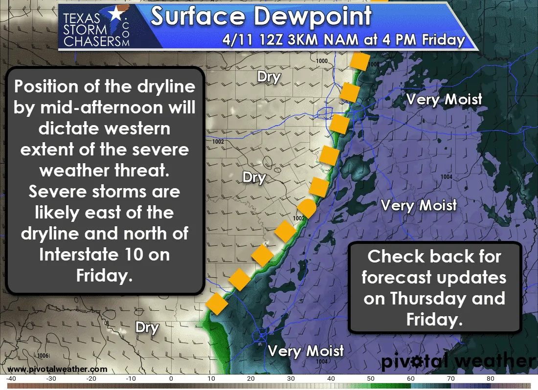
Spring has sprung and April is here. We’re now well into our Spring tornado season. It should be no surprise that a threat of severe weather is expected on Friday. Actually, the threat for severe weather fairly likely east of a surface dryline. Specific hazards and number of storms remain uncertain. What is certain is adjustments in the severe weather outlook can be expected on Thursday and Friday. Remember – storms don’t read maps. If you’re in or close to any risk area, keep an eye out.
Already a Level 3 Severe Weather Risk…
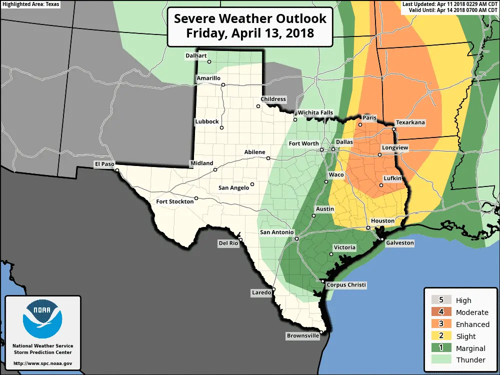
We already have a level 3 (enhanced) risk of severe weather includes most of Northeast Texas and East Texas. This risk runs along and east of Paris to Gun Barrel City to Buffalo. It runs north of a Trinity to the south of Zavalla to Browndell line. Those in this zone have a 30% chance of experiencing severe weather within 25 miles of their location.
The standard level 2 risk of severe weather runs east of a line from Bonham to Rockwall to Ennis to Marlin to Rockdale to La Grange line. It runs north of a line from La Grange to Sealy to Houston to Sabine Pass. This zone has a 15% chance of experiencing severe weather within 25 miles of any given point.
Finally, a level 1 (marginal) risk runs east of a line from Sherman to Grand Prairie to Gatesville to Marble Falls to Boerne to Pearsall to Cotulla. It runs south to Benavides to Ricardo in South Texas. The level 1 risk zone has a 5% chance of experiencing severe weather within 25 miles of any given point.
You can expect refinements to the exact line placements in future outlook updates. Portions of Northeast Texas may be upgraded to a level 4 risk in a future outlook. The Storm Prediction Center will issue their next outlook for Friday around 1 AM tonight.
Threats
All modes of severe weather (very large hail, damaging wind gusts, and a tornado threat) will be possible in the enhanced risk zone. The threat of mainly large hail and localized damaging winds will be possible in the Brazos Valley and Southeast Texas. The threat for tornadoes will depend on small-scale factors we’re unable to accurately forecast at this time range. However – current data does suggest a tornado threat will be possible – especially in Northeast Texas and East Texas.
Timing and Discussion
Isolated to scattered thunderstorms may be ongoing Friday morning in North and Northeast Texas. These storms would likely be sub-severe, but some may be strong with a threat of hail. If these storms were to occur they may set the stage for the second round in the afternoon with outflow boundaries. Low-level wind shear is enhanced near outflow boundaries, so they would play a critical role in any tornado threat with the afternoon storms.
The timing of afternoon storm development is still uncertain. If we don’t see morning storms its possible that we could see development underway by 1-2 PM along the dryline in North Texas. It is also possible storm initiation holds off until 2-4 PM. The earlier the storms fire the farther west the dryline will be. If storms take longer to develop, they would fire up farther east.
Regardless of the western edge of the severe risk – the highest threat of severe storms is expected to be in Northeast Texas and East Texas. This setup favors a discrete to semi-discrete supercelluar storm mode. Very large hail larger than the size of a baseball and localized wind gusts over 70 MPH will be possible with the strongest storms. Tornadoes cannot be ruled out, but we’ll need to get into Thursday before we can start to pin-down any areas of higher tornado risk.
Compared to last Friday’s setup this one does look to have a higher potential for tornadoes. However – it is April in Texas. These setups are bound to happen. There are several factors that could mitigate or enhance any tornado threat. We’ll get a better idea of those factors tomorrow into Friday morning. Severe weather is likely. Make sure you and your family have a way to receive severe weather warnings. Even if you don’t have to deal with storms on Friday, it’s always a good idea to refresh your plan.
Looking for tips on a severe weather safety plan? We’ve got a page full of information compiled here.
Update: The day for potential morning thunderstorms originally said ‘Thursday morning’. This has been corrected to the proper ‘Friday morning’.

0 Comments