
Hurricane and Storm Surge Watches have been issued for the Lower Texas Gulf Coast, the Coastal Bend, and the Middle Texas Gulf Coast. Those regions have an increasing risk of hurricane-force winds and a life-threatening storm surge. The chance of impacts to the Rio Grande Valley may decrease if the track continues shifting east, while those in the Upper Texas Coast and Southeast Texas may have increasing impacts if trends continue.

Beryl has weakened to a tropical storm as it moves over the Yucatan Peninsula this afternoon. However, that weakening will be temporary. After the center of circulation moves into hte Gulf of Mexico tonight, we’ll be closely monitoring to see how long it takes for reorganization to occur. It is plausible that most of Saturday goes by without significant intensification or organization.
However, as the system slowly approaches the Texas Gulf Coast on Sunday, conditions will become more favorable for an accelerated pace of intensification. Truthfully, if Beryl can organize more quickly tomorrow, we will become much more bullish with future intensity forecasts.
Prepare for a Category 2 or 3 Hurricane
Currently, we’re forecasting a high-end category one hurricane at landfall early Monday in the Coastal Bend. We always advise you to prepare for the next higher category to be safe. We’d encourage folks to prepare for a category three hurricane, even though the current forecast is for a high-end one. Keep in mind that strong to damaging winds will continue into inland regions where the inner core of the hurricane moves.

The northern trend in forecast data has continued, and the new forecast from the National Hurricane Center has been moved east. It is worth noting that their forecast remains on the western edge of the weather model envelope, and additional eastward adjustments may be needed for tonight’s forecast. This may result in additional hurricane and storm surge watches issued for portions of the Upper Texas Coast. Data continues to slow the hurricane’s forward motion as it approaches the coast on Sunday and Monday.
Heavy Rain and Flood Threat Increasing
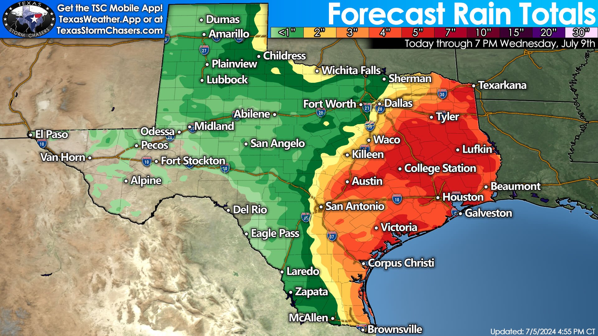
After landfall, the system will slowly begin to turn north and eventually northeast. It may take until Wednesday or Thursday for Beryl’s remnants to exit Texas. A significant rain event is now forecast across the eastern third of Texas. Due to the eastern shift in the track, these totals have been expanded east, while some folks west of I-35 and in Deep South Texas have seen some reductions.
Five to ten inches of rain, with locally higher amounts, are likely near and east of the system’s track beginning Sunday night through Wednesday. We’ve been dry lately, but we’ll likely see a flooding threat materialize early next week. In addition, we’re still going to have scattered showers and storms across most of Texas this weekend and next week thanks to the heat dome shifting into the western United States. We would have had those rain chances even without a hurricane adding to them.
Full 4 PM National Hurricane Center Advisory
Tropical Storm Beryl Advisory Number 29
NWS National Hurricane Center Miami FL AL022024
400 PM CDT Fri Jul 05 2024
…HURRICANE AND STORM SURGE WATCHES ISSUED FOR PORTIONS OF THE
WESTERN GULF COAST…
…CENTER OF BERYL EXPECTED TO EMERGE OVER THE GULF OF MEXICO
DURING THE NEXT FEW HOURS…
SUMMARY OF 400 PM CDT…2100 UTC…INFORMATION
———————————————-
LOCATION…21.2N 89.2W
ABOUT 35 MI…55 KM ESE OF PROGRESO MEXICO
ABOUT 610 MI…985 KM ESE OF BROWNSVILLE TEXAS
MAXIMUM SUSTAINED WINDS…65 MPH…100 KM/H
PRESENT MOVEMENT…WNW OR 295 DEGREES AT 15 MPH…24 KM/H
MINIMUM CENTRAL PRESSURE…989 MB…29.21 INCHES
WATCHES AND WARNINGS
——————–
CHANGES WITH THIS ADVISORY:
A Hurricane Watch is now in effect for the Texas coast from the
mouth of the Rio Grande northward to Sargent.
A Storm Surge Watch is now in effect for the Texas coast from the
mouth of the Rio Grande northward to Sargent.
The Meteorological Service of Mexico has issued a Hurricane Watch
for the northeastern coast of Mexico from Barra el Mezquital to
the mouth of the Rio Grande.
SUMMARY OF WATCHES AND WARNINGS IN EFFECT:
A Hurricane Watch is in effect for…
* The Texas coast from the mouth of the Rio Grande northward
to Sargent
* The northeastern coast from mainland Mexico from Barra el
Mezquital to the mouth of the Rio Grande
A Storm Surge Watch is in effect for…
* The Texas coast from the mouth of the Rio Grande northward
to Sargent
A Tropical Storm Warning is in effect for…
* The coast of the Yucatan Peninsula of Mexico west of Cabo
Catoche to Campeche
A Hurricane Watch means that hurricane conditions are possible
within the watch area. A watch is typically issued 48 hours
before the anticipated first occurrence of tropical-storm-force
winds, conditions that make outside preparations difficult or
dangerous.
A Storm Surge Watch means there is a possibility of life-
threatening inundation, from rising water moving inland from the
coastline, in the indicated locations during the next 48 hours.
For a depiction of areas at risk, please see the National Weather
Service Storm Surge Watch/Warning Graphic, available at
hurricanes.gov.
A Tropical Storm Warning means that tropical storm conditions are
expected somewhere within the warning area.
Interests elsewhere in northeastern Mexico and the Texas coast
should closely monitor the progress of Beryl. Additional watches
and warnings will likely be issued for portions of this area
tonight and Saturday.
For storm information specific to your area in the United States,
including possible inland watches and warnings, please monitor
products issued by your local National Weather Service forecast
office. For storm information specific to your area outside of the
United States, please monitor products issued by your national
meteorological service.
DISCUSSION AND OUTLOOK
———————-
At 400 PM CDT (2100 UTC), the center of Tropical Storm Beryl was
located near latitude 21.2 North, longitude 89.2 West. Beryl is
moving toward the west-northwest near 15 mph (24 km/h). A west-
northwestward motion is expected through tonight, with the center
forecast to emerge over the southwestern Gulf of Mexico during the
next few hours. A turn toward the northwest is expected on
Saturday, with the center of Beryl expected to approach the western
Gulf coast late Sunday and Sunday night.
Maximum sustained winds have decreased to near 65 mph (100 km/h)
with higher gusts. Continued weakening is expected during the
next few hours as Beryl crosses the Yucatan Peninsula.
Re-intensification is expected once the center moves back over the
Gulf of Mexico, and Beryl is forecast to regain hurricane status
on Sunday.
Tropical-storm-force winds extend outward up to 105 miles (165 km)
from the center.
The estimated minimum central pressure is 989 mb (29.21 inches).
HAZARDS AFFECTING LAND
———————-
Key messages for Beryl can be found in the Tropical Cyclone
Discussion under AWIPS header MIATCDAT2, WMO header WTNT42 KNHC,
and on the NHC website at hurricanes.gov/text/MIATCDAT2.shtml.
WIND: Tropical storm conditions are occurring over portions of
the northern Yucatan Peninsula and should spread westward along the
Gulf coast of the peninsula for the next several hours.
Hurricane conditions are possible in the hurricane watch area along
the western Gulf coast by late Sunday, and tropical storm
conditions are possible in the watch area on Sunday.
STORM SURGE: The combination of storm surge and tide
will cause normally dry areas near the coast to be flooded by
rising waters moving inland from the shoreline. The water could
reach the following heights above ground somewhere in the indicated
areas if the peak surge occurs at the time of high tide…
Baffin Bay, TX to Sargent, TX…3-5 ft
Corpus Christi Bay…3-5 ft
Matagorda Bay…3-5 ft
Mouth of the Rio Grande, TX to Baffin Bay, TX…2-4 ft
The deepest water will occur along the immediate coast near and to
the right of the center, where the surge will be accompanied by
large and destructive waves. Surge-related flooding depends on the
relative timing of the surge and the tidal cycle, and can vary
greatly over short distances. For information specific to your
area, please see products issued by your local National Weather
Service forecast office.
For a complete depiction of areas at risk of storm surge inundation,
please see the National Weather Service Peak Storm Surge Graphic,
available at hurricanes.gov/graphics_at2.shtml?peakSurge.
Storm surge could raise water levels by as much as 1 to 3 feet
above ground level in areas of onshore winds along the west and
north coasts of the Yucatan Peninsula in the tropical storm
warning area. Near the coast, the surge will be accompanied by
large and destructive waves.
RAINFALL: Through today Beryl is expected to produce rainfall
totals of 4 to 6 inches, with localized amounts of 10 inches, across
the Yucatan Peninsula, with scattered instances of flash flooding
anticipated.
Heavy rainfall of 5 to 10 inches with localized amounts of 15 inches
is expected across portions of the Texas Gulf Coast and eastern
Texas beginning late Sunday through the middle of next week. This
rainfall is expected to produce areas of flash and urban flooding.
For a complete depiction of forecast rainfall and flash flooding
associated with Tropical Storm Beryl, please see the National
Weather Service Storm Total Rainfall Graphic, available at
hurricanes.gov/graphics_at2.shtml?rainqpf and the Flash Flood Risk
graphic at hurricanes.gov/graphics_at2.shtml?ero
SURF: Large swells generated by Beryl are currently impacting
portions of the coast of Cuba, the Cayman Islands, and the
Yucatan Peninsula. The swells are expected to reach eastern Mexico
and much of the Gulf Coast of the U.S. by late today. These swells
are expected to cause life-threatening surf and rip current
conditions. Please consult products from your local weather office.
NEXT ADVISORY
————-
Next intermediate advisory at 700 PM CDT.
Next complete advisory at 1000 PM CDT.
0 Comments