
Good morning and welcome to February! It certainly will not feel like it today with very warm temperatures. A strong cold front will push through the northern half of Texas by tomorrow morning. That front and a developing surface low will bring significant weather impacts to the western half of Texas today. We’re not expecting severe thunderstorms with this front but the impacts will be more typical of a dry-season event. We’ve got a lot to talk about so stick with me. I’ll get through the temperature forecasts for today and tonight. After that I’ll dive into the specific-hazards we’re expecting late this morning through late this afternoon.
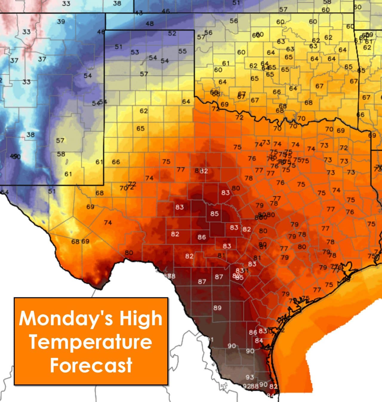
Temperatures this afternoon will have a fifty degree spread across Texas. The northern Texas Panhandle will feel the effects of the cold front first today. High temperatures in the Panhandle will range from the upper 40s near Texline to the upper 50s by the time you get to Interstate 40 and Amarillo. High temperatures will peak in the lower 60s across the South Plains and Rolling Plains early this afternoon before falling. Well-above average temperatures in the 70s are expected by this afternoon across the Permian Basin, Northwest Texas, North Texas, Northeast Texas, and East Texas. Flat out hot temperatures in the mid to upper 80s will occur this afternoon as downslope winds increase ahead of the cold front across the Concho Valley, Hill Country, and South-Central Texas. The Rio Grande Valley will set new record highs today as temperatures soar into the low and mid 90s. Yes – I just said 90s! It is way too early in the year to be talking about that kind of heat. Today will be the last day we’ll be seeing those readings for a while.
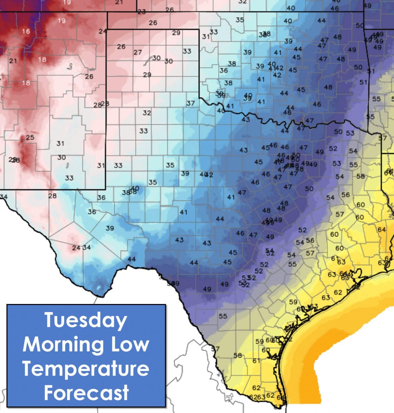
Showers will be possible across North Texas and Northeast Texas this evening through about 5 AM Tuesday. Any rain accumulations will be very light and no severe weather is expected. Another round of fog and warm overnight temperatures will be common across the Rio Grande Valley, Coastal Plains, Southeast Texas, and East Texas tonight. Those locations will be south and east the cold front by sunrise Tuesday. The Hill Country, Central Texas, North Texas, and Texoma will drop off into the mid and upper 40s tonight as a cold front moves through overnight. The Permian Basin, Northwest Texas, South Plains, and Rolling Plains will drop off into the 30s. Finally the Panhandle will drop off into the 20s tonight as cold air advection continues behind the cold front.
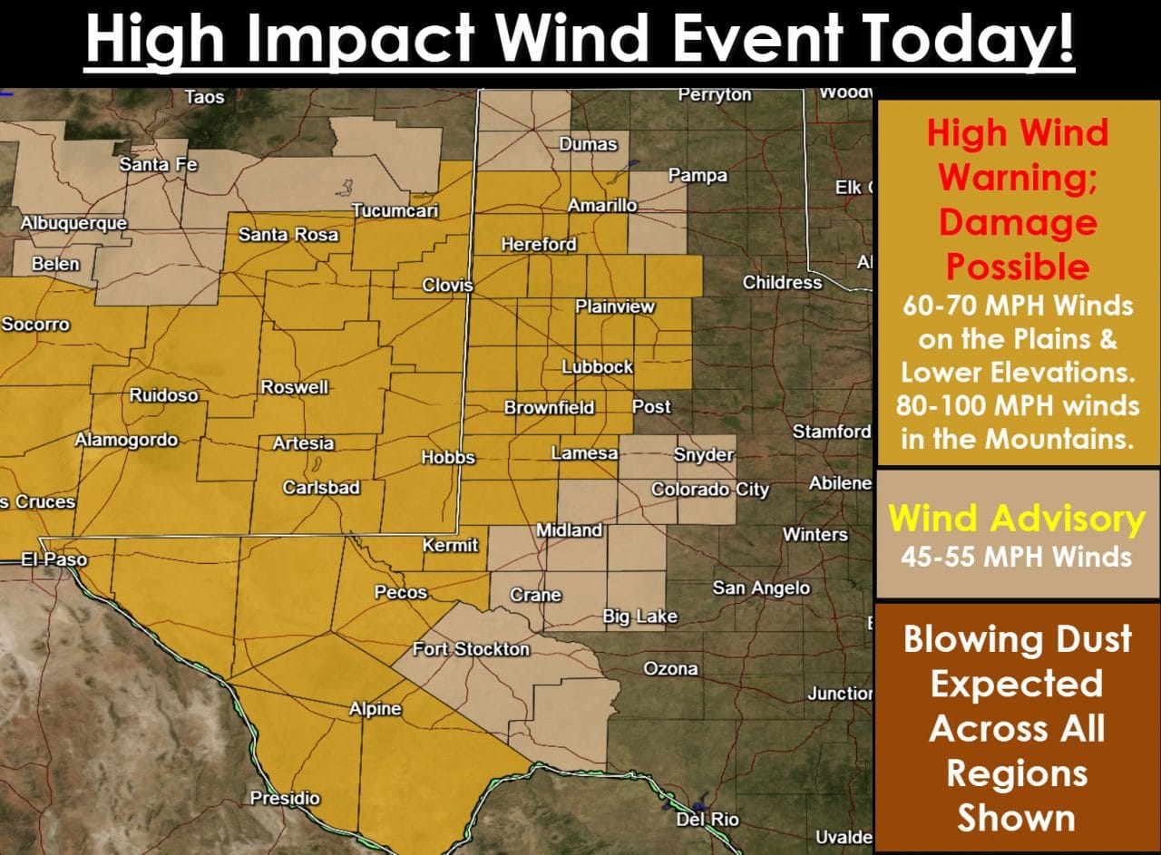
A cold front will push east across the Texas Panhandle, South Plains, Rolling Plains, the Permian Basin, and western sections of the Big Country and Concho Valley by this afternoon. Winds will become southwesterly/westerly after the frontal passage. A pressure gradient will build by late morning as a storm system takes shape. That low will eject northeast out of Texas by this evening helping to lessen the pressure gradient. Winds will become very strong by early afternoon across Far West Texas, the Permian Basin, Rolling Plains, South Plains, and the southern half of the Panhandle. Wind gusts up to 70 MPH are possible across the Plains and lower elevations. There is concern that the Guadalupe Mountains could see wind gusts approach 100 MPH during the peak of the event this afternoon. These high winds will also impact much of Southeastern New Mexico. Widespread blowing dust will move across the western half of Texas this afternoon. Reductions in visibility are possible and some locations could see a full-fledged dust storm. If this was a year ago I would be very concerned about a dust-bowl era event. Fortunately we’ve rid ourselves of the drought and thus while we expect blowing dust today – it shouldn’t be ridiculously dense. We’ll see winds start to diminish by dinner time – but they’ll remain noticeable tonight. South winds will become gusty up to around 30 MPH across the eastern half of Texas today and tonight.
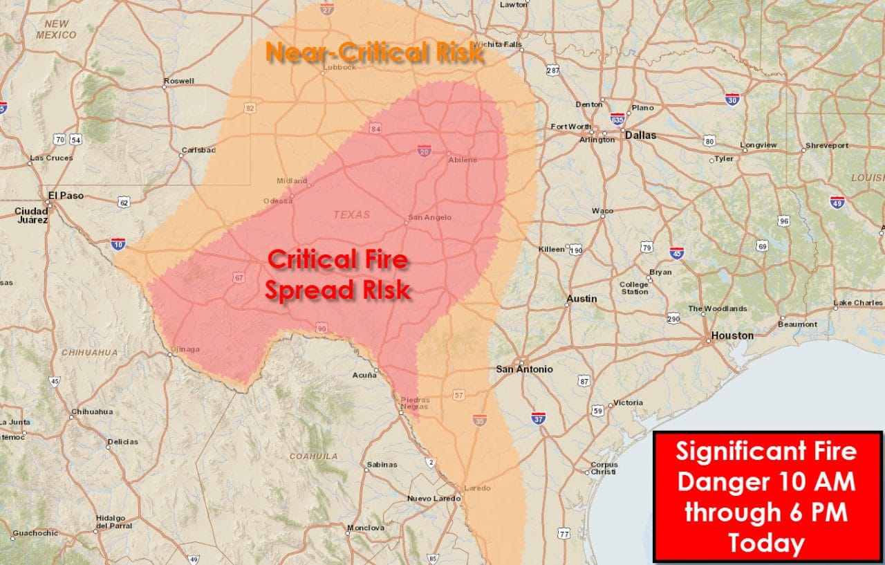
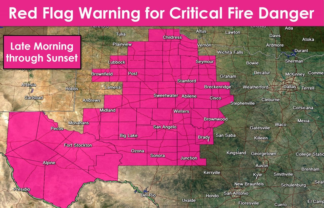
Very warm temperatures, low humidity values, and strong winds will once again result in critical fire weather danger across many areas we’ve already talked about above. In addition the fire danger will be very high to critical across Northwest Texas, the Big Country, the Concho Valley, the Hill Country, and western portions of North Central Texas. Any fires that develop could spread rapidly – perhaps explosively in locations where we have the very high winds. Relative humidity values will drop in the 5-20 percent range by early afternoon. Temperatures will be in the 60s and 70s with southwest winds. Outdoor use of flame – including welding – is strongly discouraged today. It only takes one spark to start a field fire and any of those we get today will likely spread rapidly.

0 Comments