Severe thunderstorms are possible through the evening hours across eastern North Texas, Northeast Texas, and East Texas. We’ll likely be dealing with isolated to scattered superceulluar thunderstorms. Storm motion will be to the northeast quickly at 50 MPH. The most intense storms may produce large hail, damaging wind gusts, and a few tornadoes. As a cool front moves southeast this evening, a line of showers and storms will form along it. Some storms in that squall line may produce pocket-change-size hail and localized damaging wind gusts. A brief tornado can’t be ruled out tonight with the squall line, but the overall tornado threat will be lower than discrete storms earlier in the day. Those storms will move southeast into the Brazos Valley, East Texas, and Southeast Texas tonight. Keep an eye on the sky with our interactive weather radar – available in our mobile app and website. Thank you to those who have helped support our live severe weather coverage and storm-chasing videos. We appreciate you!
FREE Interactive Radar: https://texasstormchasers.com/radar/
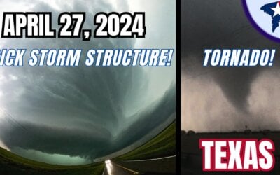
Knox City & Seymour, Texas Beastly Supercell, Tornadoes (4/27/24) {B-AB-T-JB}
Our chasers Brett Wright @WxMstr, Jenny Brown, Trey Greenwood @ConvectiveChronicles and Alex Bartholomew captured a...


0 Comments