
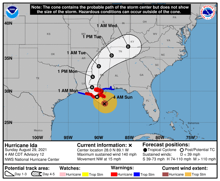
Major Hurricane Ida has continued to intensify quickly this morning. Maximum sustained winds have increased to 145 MPH with wind gusts over 160 MPH. It should be noted those extreme winds are confined to a small portion of the northeastern eyewall. Storm surge is arriving in far Southeastern Louisiana with SW Pass, LA showing a 7-foot surge already.
The hurricane is still a few hours from landfall. After making landfall southwest of New Orleans, the hurricane’s eastern eyewall looks likely to impact the city directly. Destructive winds are likely! We’ve got crews set up west/southwest of New Orleans. They’re planning on going live on our YouTube channel (which will post to our website/app) around 6:30 AM. Please understand that, unlike last year’s hurricane intercepts, we’re in much more rural locations this time. Celluar internet may not stay up for long, so we may not be able to stream live video during the worst of Ida. We’ll do our best!


Hurricane Ida Tropical Cyclone Update
NWS National Hurricane Center Miami FL AL092021
500 AM CDT Sun Aug 29 2021
…NOAA HURRICANE HUNTERS FIND IDA HAS CONTINUED TO STRENGTHEN…
…EXTREMELY DANGEROUS CATEGORY 4 HURRICANE IDA EXPECTED TO MAKE
LANDFALL IN SOUTHEASTERN LOUISIANA LATER TODAY…
Reports from a NOAA Hurricane Hunter aircraft indicate that maximum
sustained winds have increased to 145 mph (230 km/h).
A NOAA C-MAN station at Southwest Pass, Louisiana, recently reported
a sustained wind of 60 mph (96 km/h) and a gust to 74 mph (118
km/h).
SUMMARY OF 500 AM CDT…1000 UTC…INFORMATION
———————————————-
LOCATION…28.2N 89.3W
ABOUT 80 MI…130 KM SSE OF GRAND ISLE LOUISIANA
ABOUT 65 MI…100 KM S OF THE MOUTH OF THE MISSISSIPPI RIVER
MAXIMUM SUSTAINED WINDS…145 MPH…230 KM/H
PRESENT MOVEMENT…NW OR 315 DEGREES AT 15 MPH…24 KM/H
MINIMUM CENTRAL PRESSURE…946 MB…27.93 INCHES
0 Comments