
March 28, 2000, was a typical spring day across North Texas. Temperatures were in the upper 70s, dewpoints had risen into the 60s, and we were still dealing with smoke from agricultural fires in Mexico. I was eight years old and had been entranced by the weather for several years. It also just happened to be my mother’s birthday. Who doesn’t enjoy spending their birthday in a closet under the stairs as a tornado passes a mile away? I watched David Finfrock show a tornado live on a tower cam in downtown Fort Worth, listened to Troy Dungan talk about increasing rotation near Arlington, and saw power flashes (exploding transformers) as a large tornado crossed Interstate 20. Of course, I didn’t know what power-flashes were, but I thought it was cool that there were green flashes. My mom, who just heard about a confirmed tornado just miles away, was not as amused and ushered us into the closet. Oh, I had the flu that entire week too.
The severe weather forecast for Tuesday, March 28, 2000
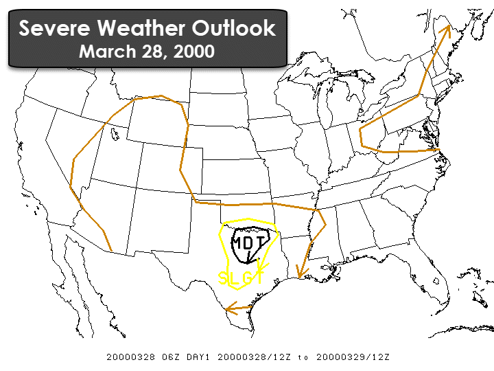
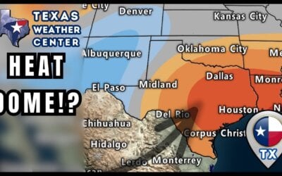
The Storm Prediction Center had issued a moderate risk (level 4 out of 5 on today’s risk scale) of severe weather early that Tuesday morning. Their outlook highlighted the potential for very large hail, destructive wind gusts, and the potential for tornadoes across North Texas. They were expecting a fairly rapid upscale growth into a squall line or cluster of thunderstorms. That would have resulted in a lower risk of tornadoes compared to damaging wind gusts. However, they noted that with enhanced low-level wind shear across North Texas, the threat of tornadoes would exist.
Ingredients come together to support severe weather
A fast-moving upper-level storm system brought strong wind shear across much of Texas that Tuesday. Mid-level winds were out of the west/southwest at about 50 to 70 MPH. Winds in the low-levels of the atmosphere were out of the south/southeast at 20 to 30 MPH. Those low-level winds weren’t extremely strong, but their ‘backing’, or becoming more southeasterly, resulted in enhanced low-level shear. While not shown, instability values were in the strong to the extreme category with CAPE (Convective Available Potential Energy) values over 4,000 joules per kilogram. That’s like throwing gasoline on a fire when a thunderstorm taps into that.
It’s not a surprise that when thunderstorms were exploding by 4:30 PM they began throwing out large hail almost immediately across Texoma and western North Texas. The low-level wind shear may not have explicitly supported a high tornado threat at that hour, but ingredients were in place for big hail – like most ‘dryline’ days in the spring. As thunderstorms evolved over the coming hour they began to ‘split’ with multiple left-moving and right-moving storms. Left-split storms tend to move northeast while right-turning storms move southeast, sometimes even more south than the southeast. It is those right-split supercells that have a higher tendency to become tornadic. The reasoning is that those storms moving more deviant to the flow aloft are able to ‘increase’ the amount of rotation available. Left-split storms rotate anti-cyclonically, which results in a big-time hail threat, but generally a lower threat of producing tornadoes. Storms in the Northern Hemisphere will rotate, or spin, cyclonically in most situations. Why did I go all nerdy there? When you have multiple storms moving in different directions over a small area you tend to get storm collisions or investigations. Those small-scale events can dramatically increase thunderstorm intensity and by effect, the potential for tornadoes.
Storms rapidly develop in western North Texas
The storm that would go on to produce the Fort Worth tornado began at 4:20 PM on March 28, 2000, near Highway 281 and Interstate 20 in southeastern Palo Pinto County. It is not an overstatement when I say the storm’s intensity exploded over the coming 30 minutes. It passed over Weatherford at 5:10 PM with a damaging hail core and with at least 4 separate severe thunderstorms within 25 miles. This storm was the southernmost, or tail-end charlie. It had access to all the unstable air it could ingest. It entered northwest Tarrant county at 5:35 PM with golfball to tennis-ball size hail occurring near Azle. Then the storm did something that we often watch for in the spring-time. It ‘turned right’ or began moving east/southeast versus to the northeast. That ‘turn’ allowed the storm to enhance its environment and increase the amount of ‘spin’ available. The hail core went bonkers and began producing softball size hail on Highway 199 from Lake Worth into Northwest Fort Worth.
The ‘Fort Worth Storm’ takes a turn for the worse
A series of cell mergers occurred between 5:55 PM and 6:10 PM as the storm(s) made their way toward downtown Fort Worth. Up to this point, the main concern had been extremely large hail. However, meteorologists at the National Weather Service in Fort Worth noted a strong mesocyclone developing in the mid-levels of the storm. With each radar scan that strong rotation was lowering in the storm. A tornado warning was issued for Tarrant county at 6:10 PM when spotters reported strong low-level rotation west of Meacham Field. The storm was being impacted by approaching severe storms from Parker County and a severe storm over Crowley and Burleson. Let’s dive into the specifics with the survey report from the NWS Fort Worth.
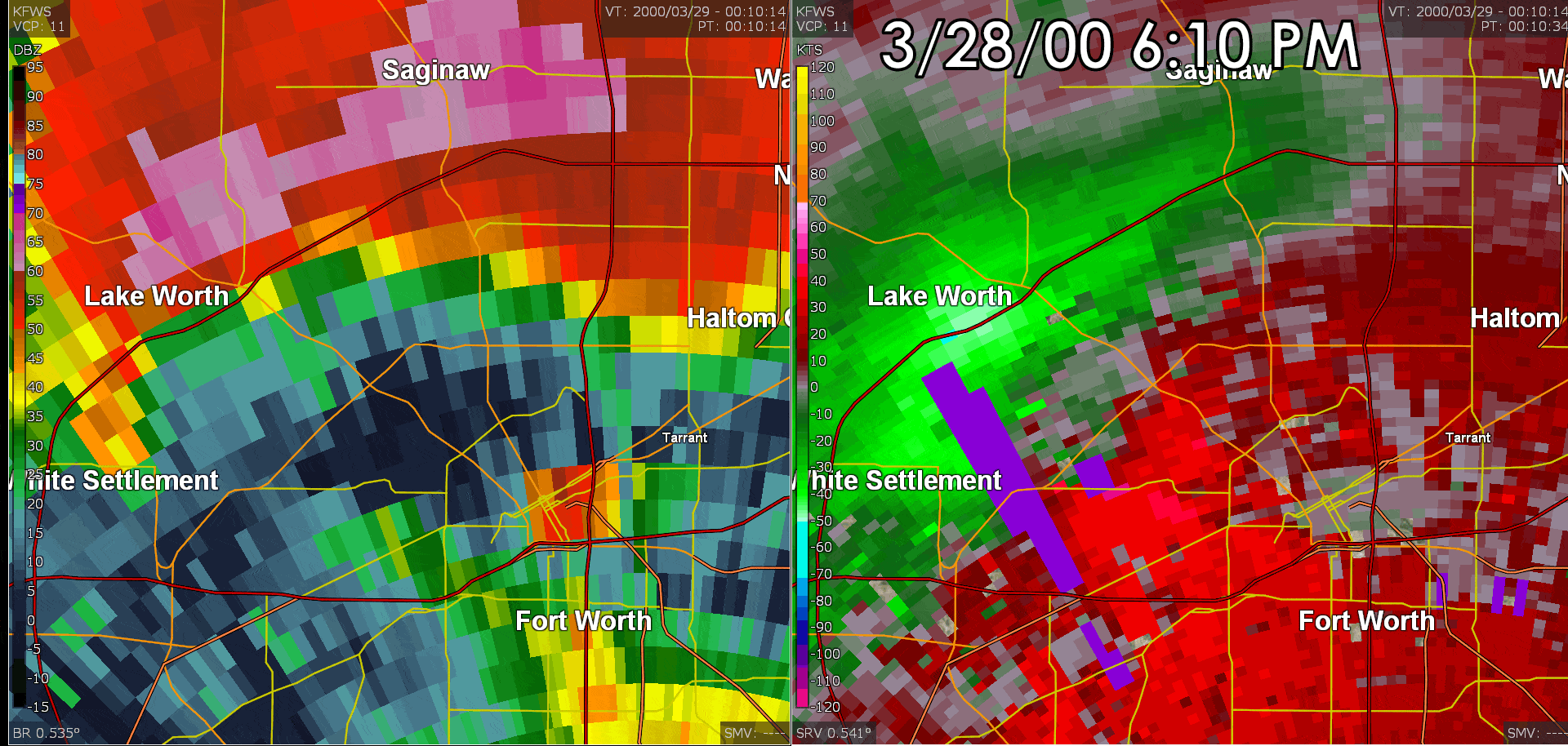
Radar data from the KFWS NEXRAD Radar located in Burleson. The left-pane is reflectivity (how hard its raining) while the right-pane is velocity (which way the wind is blowing). Notice the reflectivity enhancement as the hook-echo approaches downtown Fort Worth. That’s a debris ball – or the radar beam reflecting off pieces of debris that are airborne! Please note that the high-rise buildings in downtown Fort Worth do result in ‘false returns’. This data is before the time of increased resolution or the elimination of ‘bad data’ pixels.
“The first tornado damage was reported near Castleberry High School, about four miles west of downtown Fort Worth (618 PM). Additional roof and tree damage occurred in [the] Monticello neighborhood of River Oaks. A number of businesses were then damaged or destroyed near the intersection of Camp Bowie and West Seventh (620 PM).
[The] tornado moved east along West Seventh Street, striking the Montgomery Ward building and the adjacent Linwood neighborhood, doing extensive damage to older homes (622 PM). The tornado then did extensive damage to the six-story Cash America building, nearly destroying it. Further significant damage was then done to the Mallick Tower building and Calvary Cathedral Building (624 PM). The tornado weakened as it entered downtown, but wind-borne debris broke thousands of windows in buildings and high rises (626 PM). Particularly hard hit was the Bank One Building, which had 80% (3,000) of its windows broken, and the Union Pacific Resources Building (1,300 of 5,000 windows broken).
Numerous other structures were affected to a lesser degree. Automobiles in streets and parking lots were also damaged. The tornado then dissipated as it moved east of downtown, although scattered minor damage occurred to roofs, trees, fences, and billboards about 3 miles east of the city near I-30 and Brentwood Stair. Two people were killed as a direct result of the tornado. A man (age 52) was killed while trying to reach shelter after warning others of the tornado, while a homeless man (age 67) was killed by a wall that collapsed on him. Some 80 other people were injured, but only six required hospitalization. Hail did extensive damage to roofs and autos mainly in Lake Worth and Saginaw.”
From StormData: https://www.ncdc.noaa.gov/stormevents/eventdetails.jsp?id=5137406
The Fort Worth storm weakens, but a new supercell quickly takes shape
Once the tornado dissipated the parent thunderstorm was absorbed by a larger thunderstorm originating from Benbrook and the storm from Burleson. By 6:45 PM most of Tarrant County was experiencing heavy rainfall and hail. Storms had evolved into a mushy mess with multiple updrafts and areas of mid-level rotation. However, one storm quickly took hold and tornado warnings were once again issued for Tarrant County. This new storm quickly spun-up and began producing another significant tornado.
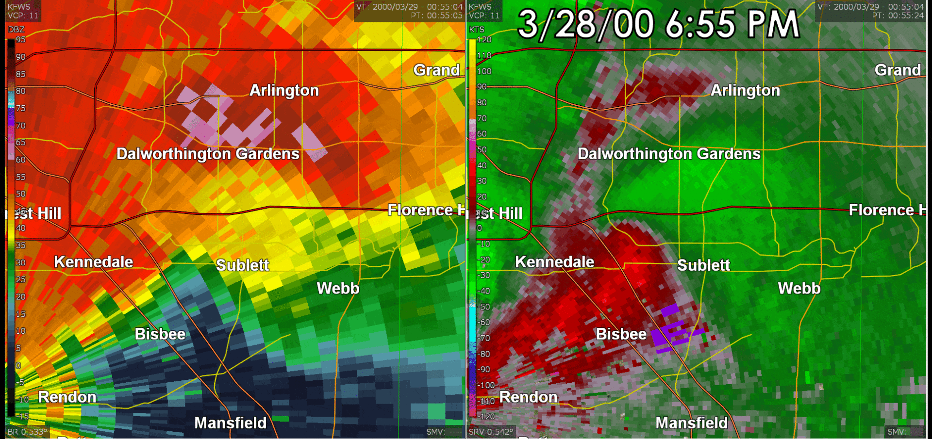
Radar data from the KFWS NEXRAD Radar located in Burleson. The left-pane is reflectivity (how hard its raining) while the right-pane is velocity (which way the wind is blowing). Unlike the Fort Worth tornado, this circulation was much more rain-wrapped. The tornado itself was hidden by a shroud of heavy rain and hail.
“Initial tornado damage in Arlington occurred at a restaurant on South Cooper Street. The tornado moved east and gained strength, doing F3 damage near Bardin and Matlock (707 PM), south of I-20. The tornado then struck the northern part of Arlington Airport (F2). The tornado paralleled I-20, crossing the Interstate about one mile west of Highway 360, overturning at least one 18-wheeler (F1)(712 PM). The tornado then began moving northeast, ending with F2 damage to subdivision just northeast of Grand Prairie airport (near Arkansas and Parkside)(720 PM). In spite of the damage, there were no deaths or serious injuries in Arlington or Grand Prairie.”
From StormData: https://www.ncdc.noaa.gov/stormevents/eventdetails.jsp?id=5137409
Personal Recollections
The Arlington tornado passed about one mile northwest of my home in southern Grand Prairie. As I shared in the introduction I actually saw the tornado illuminated by numerous transformers exploding. Those power flashes were easily discernable from lightning being they originated from the ground and were extremely frequent. After my mother shuffled us into the closet and after the storm passed we found insulation and other small debris in our yard. My grandparents were fortunate as the tornado passed only a quarter mile to their south/southeast. I got to see the damage first-hand later that night we traveled over Interstate 20 at New York Avenue. I remember street lights being bent over to the ground, vehicles rolled over on Interstate 20, and the old Johnson & Johnson plant receiving severe damage. Specifically, a large pedestrian bridge that was mostly glass being destroyed. That facility became a church for several years before the property was demolished for new industrial warehousing.
After the Arlington tornado ended
The Arlington tornado dissipated as it entered Grand Prairie and crossed Great Southwest Parkway south of Spur 303. That was the final tornado of the event in the D/FW Metroplex. Storms went on to produce heavy rainfall and flash flooding resulted – much like previous severe weather events in the metroplex. We note that a separate supercell tracked from Ellis County southeast through Navarro and Henderson counties during the evening hours. It produced at least one brief tornado along with more damaging hail.
Final personal thoughts 19 years later
I wouldn’t say that this was the event that got me into severe weather or even storm chasing. I had already been a ‘weather nerd’, but this event certainly amplified my (perhaps unhealthy) obsession with severe weather and tornadoes. I’d go as far as to say that I developed anxiety of severe weather and in general thunderstorms. We had several additional tornado events in the coming years that passed close enough to my home to cause more anxiety, and it wasn’t until my Junior High years that I began transitioning from anxiety over severe weather into curiosity and eventual exploration. 2019 will mark my 11th year chasing storms and now instead of fearing the weather I like to explain it to others in a way that will help calm them. Knowledge is power
Articles and links related to the March 28, 2000 Severe Weather Outbreak
A Case Study of the Fort Worth and Arlington Tornadic Supercells of 28 March 2000
Damage Survey and Radar Analysis of the Fort Worth and Arlington, TX Tornadoes on 28 March 2000
Video of the Fort Worth Tornado on YouTube
0 Comments