
Christmas is the day after tomorrow, and Santa will probably be visiting Texas in his swimsuit. No rain, sleet, ice, or snow is expected to occur in Texas over the next several days. Regarding travel impacts from precipitation, we’re not going to see any caused by Texas through the weekend. What may impact travel on Friday and Sunday, mainly across the Texas Panhandle and West Texas, will be high wind events – resulting in blowing dust and yet more dangerous wildfire conditions.
Very high to severe wildfire danger is forecast today across West Texas, the Permian Basin, and the Guadalupe and Davis Mountains. Low to moderate fire danger will be present across the eastern two-thirds of Texas thanks to well above average temperatures.
50 to 65 MPH west winds are forecast on Friday across the western and central Texas Panhandle and West Texas, impacting Interstates 27 and 40 – along with Highway 287. Severe to extreme wildfire danger and blowing dust will create locally hazardous travel conditions.
It’ll be rather windy across most of Texas tomorrow into Christmas Eve Night – similar to last week (though without the 90 MPH winds in the Panhandle).
TSC’s 2021 Christmas Snow Outlook for Texas
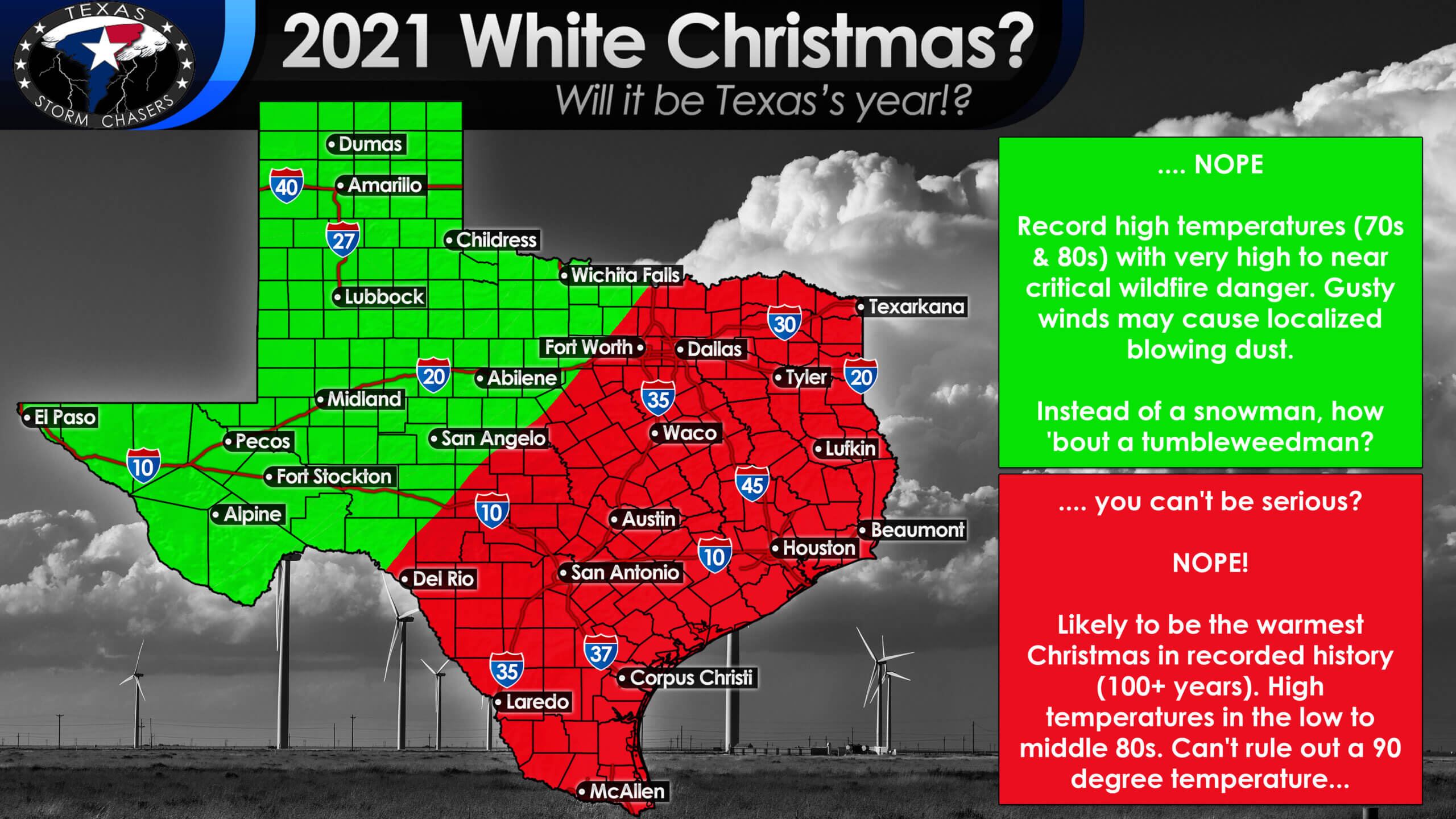
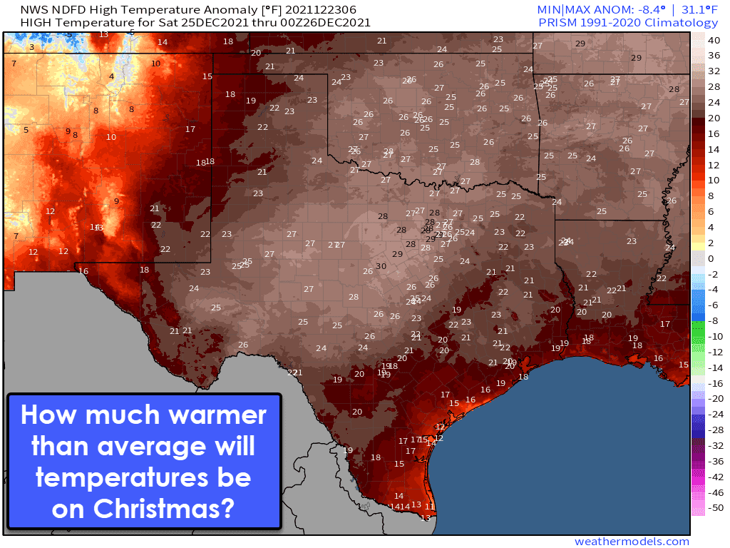
On Christmas Day (Saturday), high temperatures will approach or exceed prior record highs across Texas. Widespread upper 70s to middle 80s are likely, and a town or two in Texas may make a run at 90 degrees. Honestly, it will be a pretty good day to do outdoor activities, including pools, beaches, etc.
Rain chances are non-existent, though we remind folks that starting grass fires won’t be too challenging. Let’s not shoot fireworks or otherwise find some way to set a field on fire. There are already nearly 100 Texas wildland firefighters who will be missing out on Christmas with their loved ones because they’ll be deployed into West Texas & the Texas Panhandle this weekend.
If it makes cool weather fans feel better, extended-range weather models in voodoo land hint at an upper-level pattern change that may bring more seasonable temperatures and a chance for precipitation after January 1.
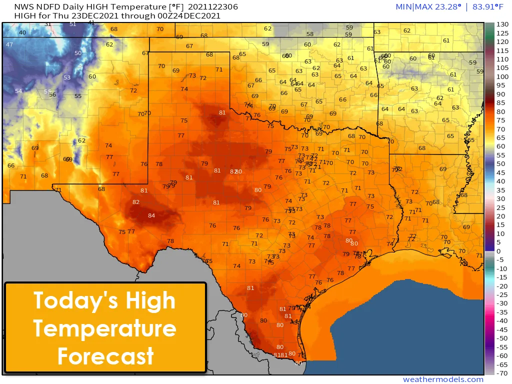
Forecast high temperatures across Texas through Monday will remain well above average or beat prior high-temperature records. Just pretend it is April, and the weather will make sense. Perhaps Mother Nature is giving us a break after this past February’s arctic hellhole or just getting ready to pull the rug out from under us in the coming months. Who knows – we sure don’t, but then, who does? Our advice is to simply smile, wave, and accept that the weather across Texas will emulate April versus the final week of December.
Memories of 2015… but no expectation for a repeat this year.
We are not anticipating any severe storms in Texas over the next five days. I know the warm weather likely brings back memories from 2015 – we are not seeing anything to suggest we will see a repeat this year (December 26, 2015 tornado outbreak). Both Christmas Day and Sunday are expected to be quite warm, but quite dry across Texas. We may be dealing with a high wind/wildfire event across western Texas on Sunday (in addition to Christmas Eve).


0 Comments