
An active two days in the thunderstorm department is expected before an early summer preview arrives this weekend. This weekend’s toasty weather will also bring a break from severe thunderstorms. Let’s dive into the latest on storm chances later today and on Thursday.
Today’s Severe Weather Outlook
Severe weather outlooks issued by the Storm Prediction Center utilize a five-level risk scale. Each risk level is based on the probability of severe storms within twenty-five miles of any given point, such as your location. A level one risk is the lowest and means isolated/short-lived severe storms are possible. A level five risk is the highest, is quite rare, and indicates a significant tornado outbreak or derecho is likely. Being in or near any risk zone means you may have stronger storms in your vicinity. View the latest Texas severe weather outlooks here.
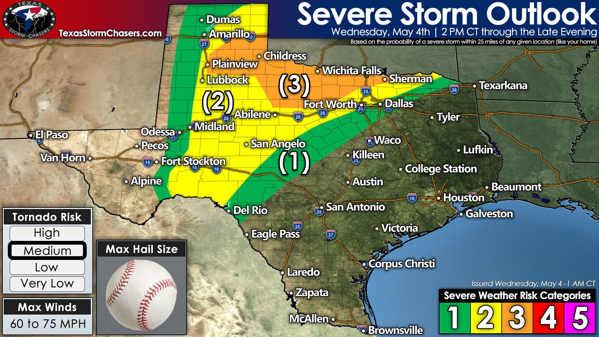
A level 3 (out of 5) risk for severe storms includes the southeastern Texas Panhandle, Northwest Texas, Texoma, and western North Texas. The standard level 2 (out of 5) risk for severe storms consists of the northeastern Texas Panhandle, West Texas, the Big Country, the Concho Valley, the eastern Permian Basin, and down into the western Edwards Plateau, and more of North Texas. Finally, a level 1 (out of 5) risk for severe storms surrounds the higher risk levels. The higher the risk level, the more likely severe storms are within or near that region. Any risk level means a risk for a severe storm.
Threats
Very large hail and damaging straight-line winds are likely with the strongest thunderstorms today and tonight. Intense supercell thunderstorms may produce hail larger than the size of baseballs. Heavy rain may result in localized flooding, especially if multiple storms move oversaturated soils.
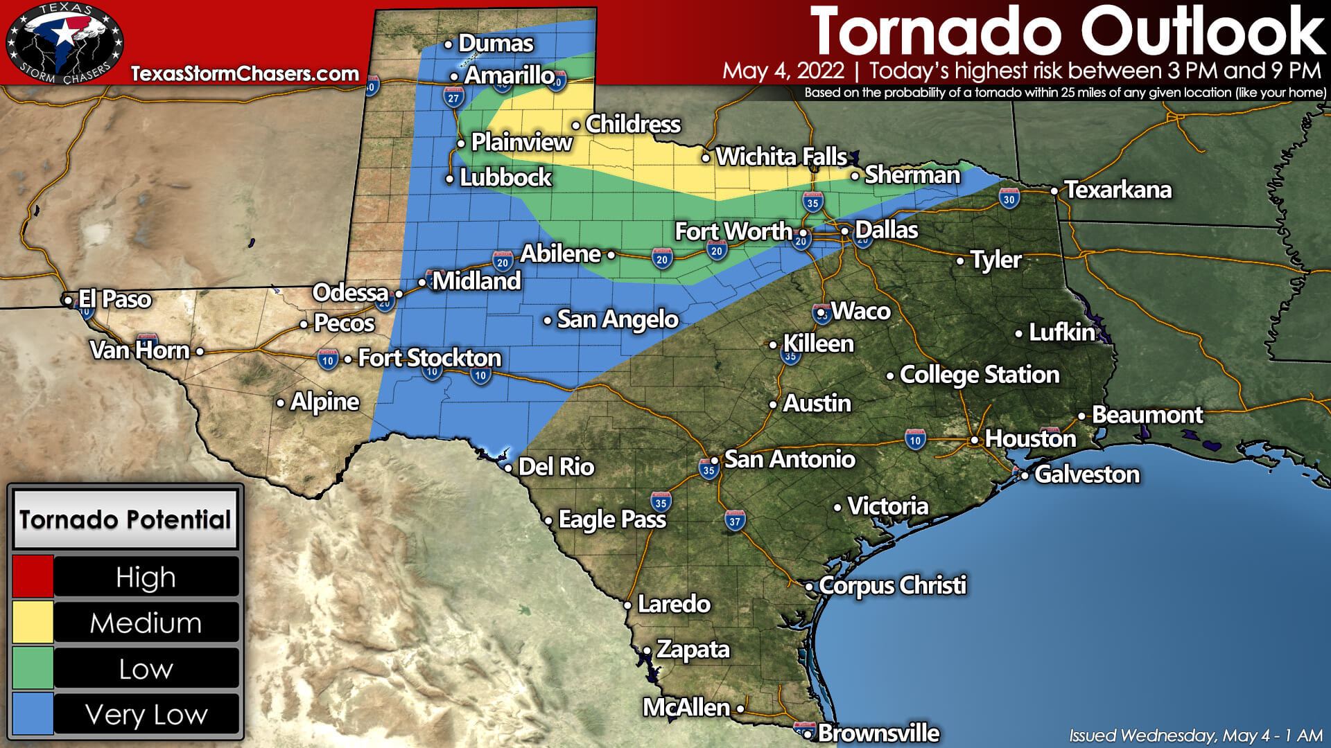
Tornadoes will also be a threat this afternoon and evening. We’re looking at a medium tornado threat across the southeastern Texas Panhandle east into Northwest Texas and Texoma. A low risk for a few tornadoes extends into the Big Country and North Texas. A tornado can’t be ruled out further south along the dryline into the Permian Basin and Concho Valley. We’ll be watching any discrete storms in the low and medium-risk zones for signs of low-level rotation.
There is a concern that we may see a strong tornado occur in the southeastern Texas Panhandle or Northwest Texas this afternoon and early this evening.
Details & Timing
Let’s start with the warm front. There was concern the warm front would set up near or south of the Red River later today in North Texas. The warm front will likely have an enhanced tornado threat near it. This morning’s data indicate that the warm front will set up shop closer to Interstate 40 in Central Oklahoma. With the warm front being so far north, we’ll have to watch Northwest Texas, Texoma, and even parts of North Texas for isolated severe storms this afternoon.
If any isolated storms do form, they would likely be severe – including some tornado risk. Storms would move north/northeast. We’ll also need to watch for any outflow boundaries from this morning’s storms – as those could also enhance the severe weather threat locally and help an isolated supercell develop.
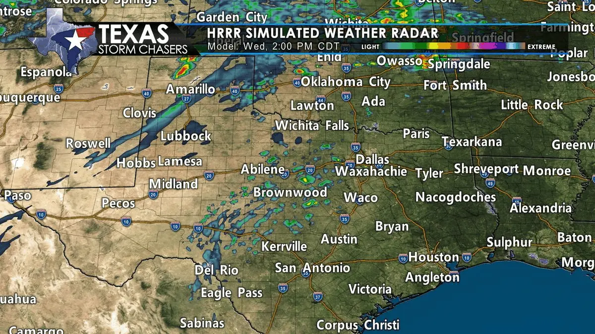
More certain is the significant severe weather threat across the eastern Texas Panhandle this afternoon. A surface low, dryline, and warm front will converge – known as a triple point – near Amarillo. Ingredients will favor significant severe weather, including tornadoes, with supercell thunderstorms that develop to the east and southeast of that triple point. That sets the eastern and southeastern Texas Panhandle under the gun. The first storms may develop in the 2 PM-4 PM timeframe. Once thunderstorms begin developing, they will intensify quickly.
Multiple supercell thunderstorms are likely in the eastern Texas Panhandle after 4 PM. Those intense thunderstorms will move east at around 35 miles per hour. Significant severe weather, including tornadoes, is likely with the most intense storms in the eastern Texas Panhandle between 4 PM and 8 PM. Those individual supercells will eventually grow upscale into a small cluster as they move into western Oklahoma early this evening. A few severe storms, including supercells, may continue in the southeastern Texas Panhandle and Northwest Texas early this evening.
Isolated thunderstorms are possible south along the dryline into West Texas and the Permian Basin this afternoon. Any storms that develop will likely become severe with a threat of very large hail. The threat for tornadoes will be lower compared to further north due to higher cloud bases and weaker low-level wind shear. We may also see a few storms in northern Mexico make a run at the Edwards Plateau this evening.
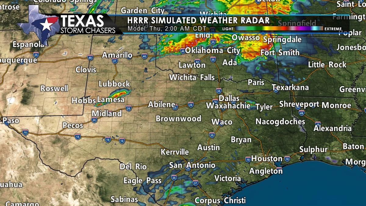
We may see thunderstorm coverage in Texas temporarily diminish after 10 PM this evening. A large cluster of thunderstorms will likely be impacting Oklahoma tonight. At the same time, a few storms may continue south of the Red River. Assuming we have a lull in storms this evening and tonight, we’ll see storm coverage increase Thursday morning as a cold front moves south.
Thursday
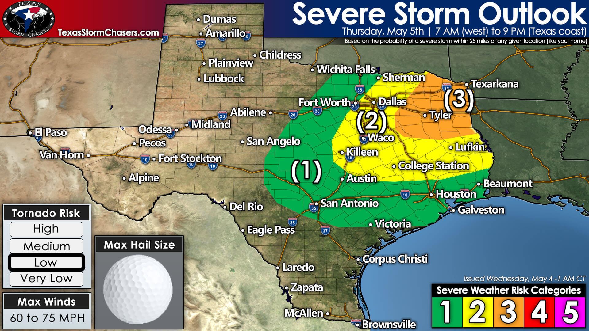
The threat of severe storms will move east on Tuesday as a cold front pushes into Texas. Tomorrow’s severe weather threat will begin during the morning hours. We expect a broken to a nearly solid line of thunderstorms to form along the cold front. That line of storms will move east/southeast through the day Thursday. Not all storms in the squall line will be severe. However, damaging straight-line winds and large hail are likely with more intense storms. Localized flooding may also occur due to heavy rainfall rates.
The threat of a few tornadoes may also exist, but the overall tornado threat will be lower than today. We’ll get more specific on tomorrow’s storm setup once we get past some of today’s activities – since they could play some role tomorrow.


0 Comments