

Today’s weather hazards will include potentially catastrophic wildfire danger, high winds, and the threat of scattered severe thunderstorms. The fire weather risk across the Texas Panhandle, West Texas, and the Permian Basin is about as high as we’ve seen since spring 2019. Ingredients coming into play include relative humidity dropping into the single digits, southwest winds gusting upwards of 50-65 miles per hour, severe to exceptional drought conditions, and burning indices that almost guarantee wildfire ignition if a spark is produced. Today’s expected ingredients are similar to previous major wildfire outbreak events.
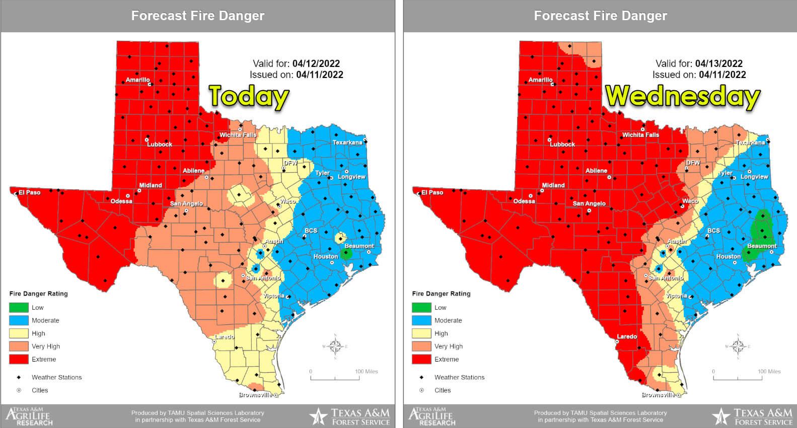
If a wildfire ignites in your area, be ready to evacuate as fires will be nearly impossible to contain today, tonight, and on Wednesday. We’ll see dangerous wildfire conditions continue tonight and on Wednesday – as an exceptionally dry airmass moves into Texas. The threat of destructive wildfires will expand eastward on Wednesday and include the western 75 percent of Texas. Wind speeds on Wednesday will be lower than today, but the airmass will be even drier. The following 48 hours will be dangerous, and I hope we can get through it without any loss of life or significant incidents.
Severe Weather Potential Today
Severe weather outlooks issued by the Storm Prediction Center utilize a five-level risk scale. Each risk level is based on the probability of severe storms within twenty-five miles of any given point, such as your location. A level one risk is the lowest and means isolated/short-lived severe storms are possible. A level five risk is the highest, is quite rare, and indicates a significant tornado outbreak or derecho is likely. Being in or near any risk zone means you may have stronger storms in your vicinity.
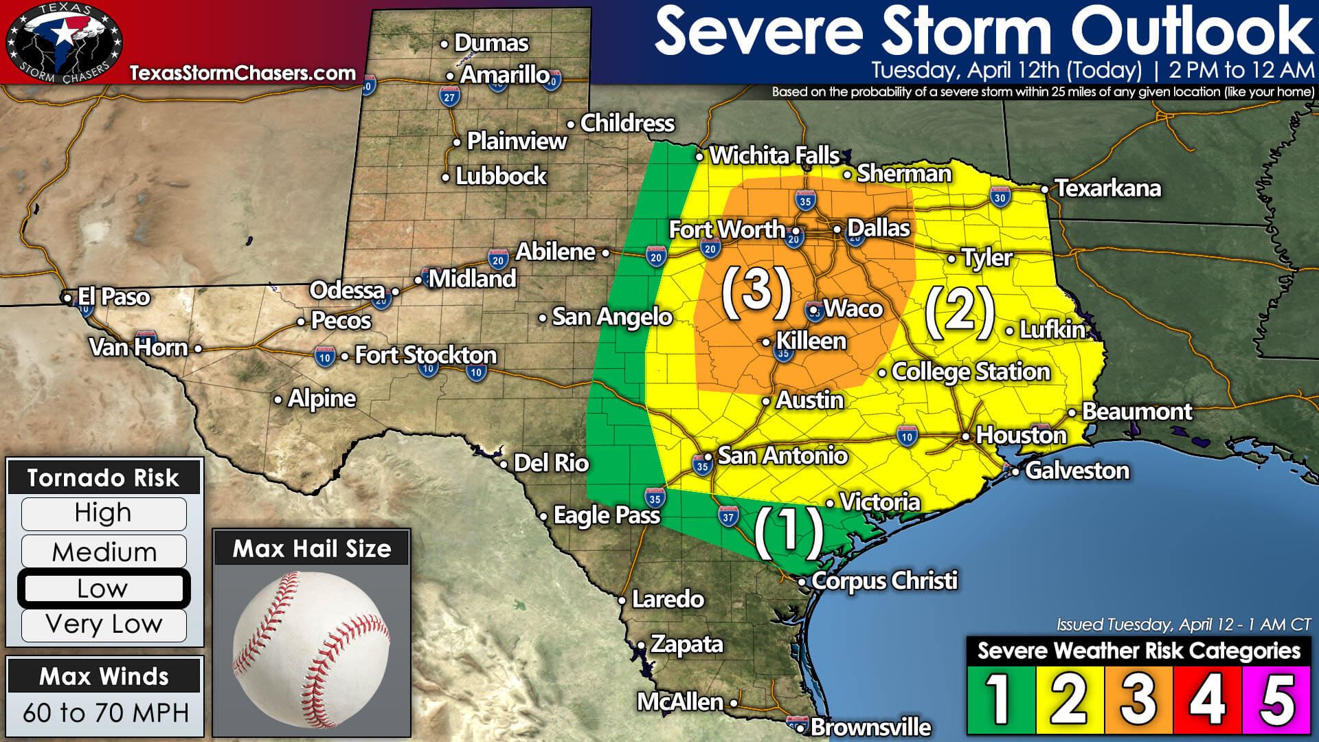
The Storm Prediction Center has maintained a level 3 out of 5 risk for severe storms across North and Central Texas. This ‘enhanced’ risk includes the D/FW Metroplex south through Waco into the Georgetown area. A level 2 out of 5 risk for severe storms runs east of a line from Wichita Falls to Uvalde to San Antonio to Victoria – east to Arkansas and Louisiana. Please don’t get hung up on the exact line or risk placements since they’re liable to change as the severe weather outlook is updated multiple times today. Any risk means a chance for a severe storm in your neck of the woods this afternoon or this evening.
Today is one of the more complex forecasts we’ve dealt with in a while. Again, we’ll be dealing with the cap or a lid on the atmosphere. Unlike yesterday, we will have a source of ‘lift’ in the regions mentioned above to work on lifting the cap. However, some timing differences could either result in numerous severe storms later today – or we may struggle to get more than a few storms. What is reasonably sure is that any storms that fire off the dryline this afternoon and this evening will become severe.
Scattered showers and even some non-severe storms are expected this morning into the early afternoon hours across parts of the Coastal Plains, South-Central Texas, and Southeast Texas. This activity should behave itself and be associated with a piece of upper-level lift.
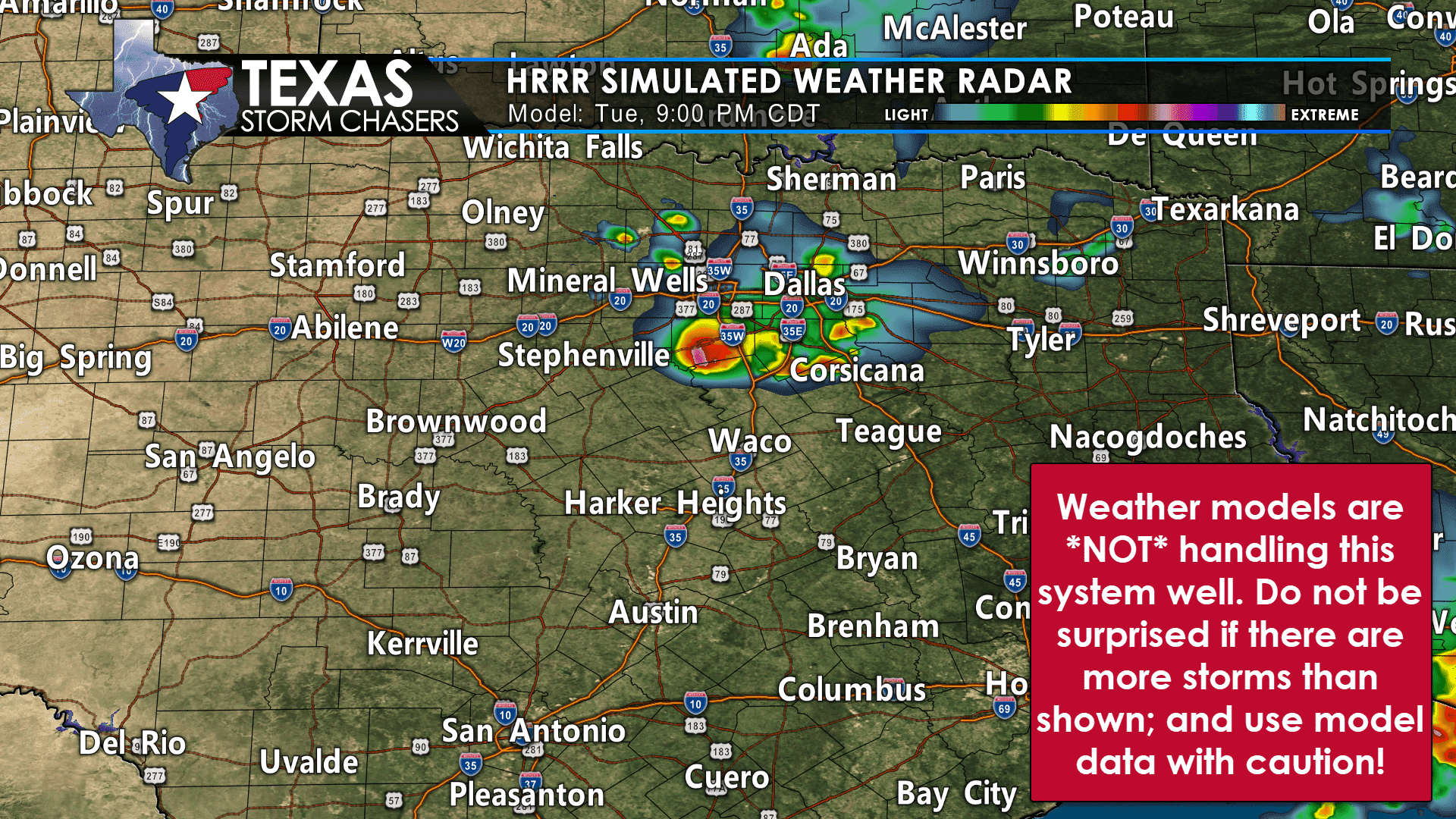
We’ll be watching for isolated to scattered thunderstorm development after 3 PM along the dryline. Short-term weather models are struggling – hard – on the exact details of where/when storms may develop. However, the atmosphere will be highly supportive of supercelluar storms.
Once a storm develops, we anticipate it will go severe quickly with the potential of producing large to very large hail. With the most intense storms, giant hail, baseball to softball size, cannot be ruled out. Localized damaging wind gusts and a few tornadoes are also threats. Low-level wind shear and somewhat high cloud bases should keep the tornado threat on the low side through 6 PM.
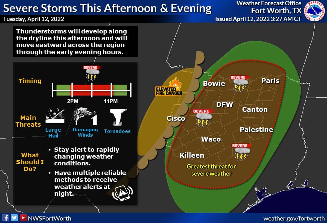
From 6-7 PM onward, we may see an uptick in tornado potential if we have discrete supercells underway. Storms will generally move northeast but will turn ‘right’ and move more easterly as they become more intense. If more numerous thunderstorms develop this afternoon, we could see storms grow upscale into a cluster or line by early evening. Those storms would have a higher chance of producing damaging straight-line winds as they move toward East/Northeast Texas.
Overnight, a cool front will move southeast and could spark off a line of storms from Southern Oklahoma to North Texas. Those storms, and the cool front, would move east/southeast Wednesday morning into East Texas, Central Texas, and eventually Southeast Texas. Some threat of damaging straight-line winds, brief tornadoes, and pocket-change size hail would exist.
I want to emphasize we’re dealing with a conditional but highly volatile severe weather threat today. High-resolution weather models are not much help. We’re going back ‘to the old days’ (which was not more than 10-15 years ago), where we have to ‘look out the window’ and observe trends. That doesn’t allow too much lead time (compared to what we may be used to these days), but that can happen on ‘dryline days.’ Pay attention and keep an eye on the sky.
You’ll know if the cap has broken because any storms that fire up will probably be visible over 100 miles away and look like a bomb exploding. There is the risk of a ‘bust factor’ here – and that would be storms not able to develop at all. If that bust factor does materialize, we’ll enjoy a primarily quiet afternoon and evening – with the chance for a line of storms overnight into Wednesday morning. That would be the best-case scenario – since the flip side would involve intense supercells dropping giant hail and perhaps even a tornado risk. The threat of storms will conclude in East Texas late Wednesday morning as activity exits Texas to the east. A much drier and cooler air mass will arrive after that.
We will have multiple folks chasing today and, if necessary, live severe weather coverage available.


0 Comments