
The stage is set for an active afternoon, evening, and night of severe weather across the eastern half of Texas. I won’t rehash what we’ve been forecasting for a few days. I’ll keep this early-afternoon update short and sweet.

The late-morning severe weather outlook from the Storm Prediction Center introduced a level 4 out of 5 risk of severe weather for portions of Central Texas, the Brazos Valley, and East Texas. A level 3 out of 5 risk continues across North Texas, the Hill Country, the northern Coastal Plains, Southeast Texas. and all of East Texas. Level 1 & Level 2 risks continue from the Texas Panhandle and West Texas down into South Texas.
I don’t want folks to get nitpicky on which risk level is where or the exact placement of the risk lines. These risks are based on the probability of severe storms within your area. The higher the risk level, the higher likelihood you have of severe storms in your area. If you’re in or near any risk level, you have a chance for a severe thunderstorm in your area. Large hail, damaging winds, and a tornado are possible in the Texas Panhandle, Northwest Texas, and Texoma this afternoon.
All modes of severe weather, including the threat for significant severe weather, are likely across the Level 3 and Level 4 risk zones. Any sustained, discrete supercells have the potential to produce strong, long-lived tornadoes. Destructive hail up to the size of softballs and hurricane-force straight-line winds over 80 miles per hour are also threats. Line segments will have a higher chance of producing hurricane-force straight-line winds and tornadoes versus big-time hail.
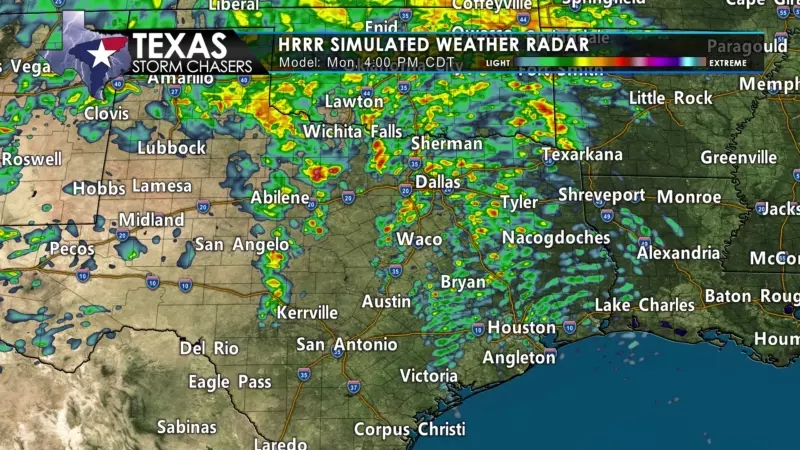
The High-Resolution Rapid Refresh (HRRR) model shows thunderstorm development occurring between 3:30 PM and 5 PM in North Texas, Central Texas, and South-Central Texas. Storms will be racing to the northeast at 45 to 55 miles per hour. We may also see storms develop well east of the dryline this afternoon.
The consistency of the model showing discrete storm modes in Central Texas, the Brazos Valley, into East Texas is concerning. Multiple long-lived supercells are likely to move northeast across portions of North Texas (especially from D/FW south), Central Texas, the Brazos Valley, and East Texas this evening. All modes of severe weather are expected, including a significant tornado threat.
Thunderstorms may take on a more linear mode across North Texas this evening, but severe weather would still be likely. By midnight and through sunrise Tuesday, our focus for severe storms will be in Northeast Texas, East Texas, Southeast Texas, and the Coastal Plains. Large hail, damaging wind gusts, and the threat of tornadoes will continue most of the night.
We’ll have live streaming severe weather coverage later this afternoon and throughout the night. Our live coverage will be embedded within our website, mobile app, and on most of our social media platforms. We also have chasers out and about, and you’ll be able to watch their video on our YouTube channel.


0 Comments