
After an eventful Sunday night, the weather across Texas has been quite a bit calmer today. We’ll remain quiet tonight before heading into an active weather pattern beginning Tuesday and continuing through Friday morning. Severe thunderstorms are possible tomorrow and tomorrow night. A decaying Pacific hurricane will significantly influence our weather on Wednesday and Thursday. Our focus will shift to heavy rain and localized flooding versus a severe thunderstorm threat.
Severe Weather Chances Tuesday & Tuesday Night
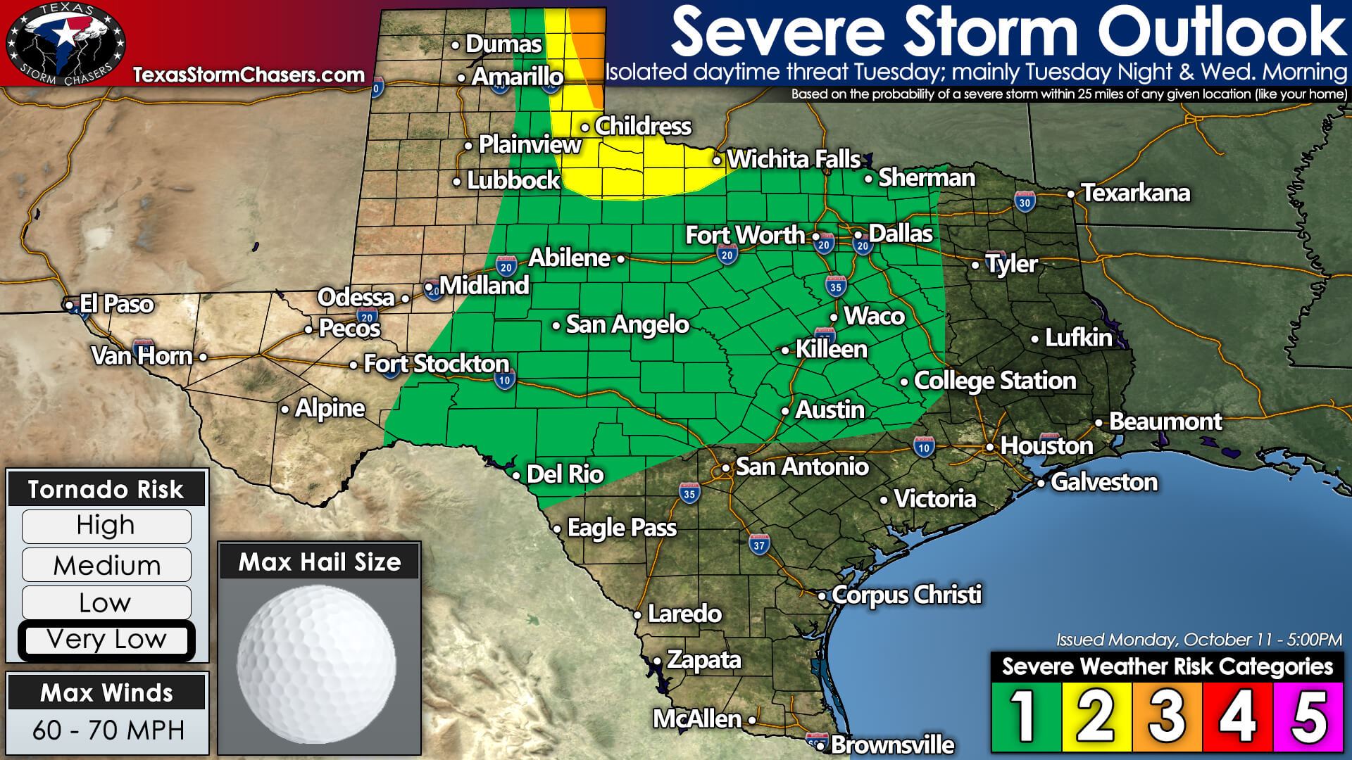
A marginal risk for isolated severe storms will exist Tuesday afternoon across the Hill Country, Central Texas, and North Texas. Pocket-change size hail and gusty winds would be possible with stronger storms as they move northeast.
Severe thunderstorms become far more likely after sunset Tuesday in the eastern Texas Panhandle and Northwest Texas. Just like yesterday, we’re expecting a line of thunderstorms to develop as strong upper-level lift arrives. We’ll have to wait until 7-10 PM for that lift to arrive. Storm development may occur relatively quickly, and storms will move northeast into western Oklahoma.
Initial storm development may be supercelluar with a threat of large hail, damaging winds, and perhaps a couple of tornadoes. Relatively rapid growth into a squall line is expected, enhancing the damaging straight-line wind threat and maybe a few brief tornadoes. We’ll fine-tune our expectations tomorrow.
Scattered thunderstorms are expected to develop further south into the western Big Country and the western Concho Valley late Tuesday night into the early morning hours on Wednesday. The strongest storms may produce hail and strong winds.
Those storms will also likely grow upscale into a squall line that moves east into North Texas in the pre-dawn hours Wednesday. Some storms may still produce strong winds, but the risk of severe weather will decrease a few hours before sunrise.’
Pacific Hurricane to bring heavy rain to Texas on Wednesday & Thursday
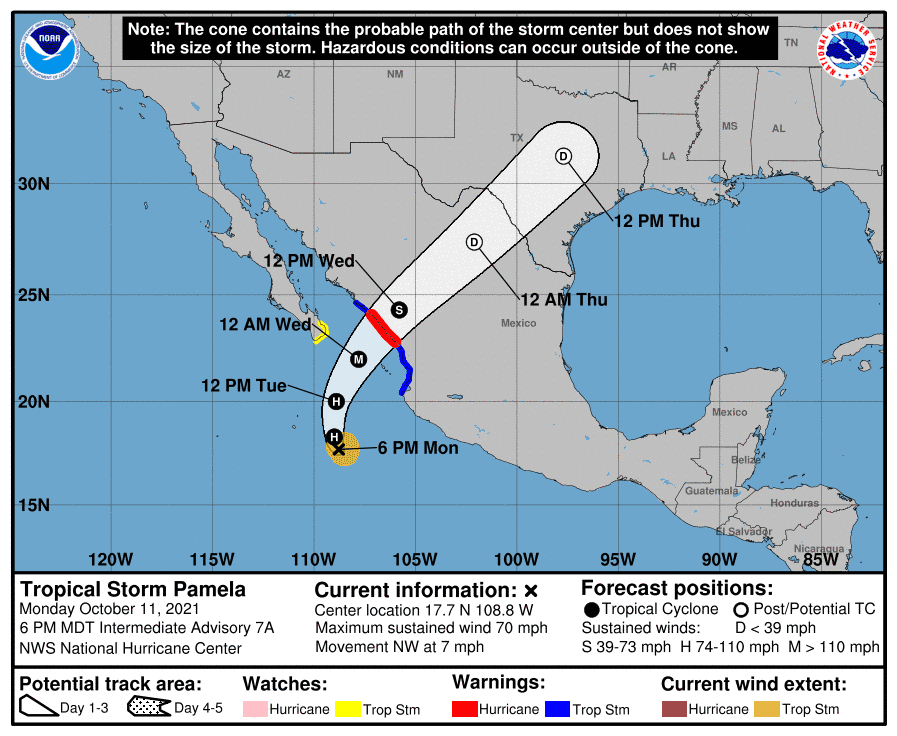
Pamela is a rapidly intensifying tropical cyclone off the coast of Southwest Mexico. It is likely to become a hurricane tonight and a major hurricane before making landfall Wednesday Morning. After that, it’ll rapidly weaken over inland Mexico as it moves northeast. Why are we talking about Pamela? Well, the moisture from Pamela is coming straight to Texas on Wednesday and Thursday. We will not experience any hurricane-related impacts such as strong winds or storm surge. Heavy rain and localized flooding, however, is going to be a hazard.
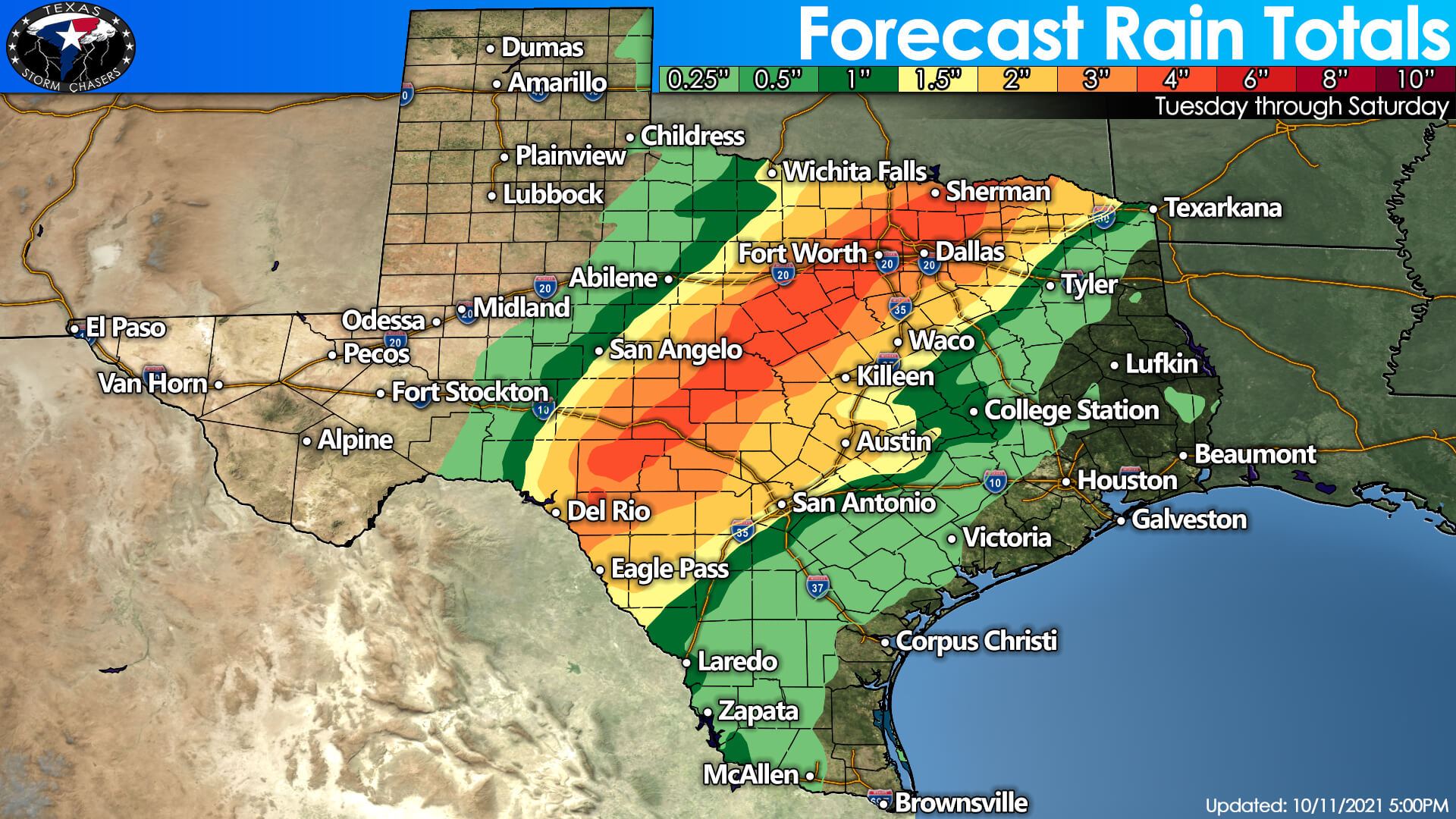
Pamela’s ‘moisture train’ will result in heavy rain chances in a corridor from the Edwards Plateau northeastward into the Hill Country, North Texas, and Texoma. We note that the axis of heavy rain may not necessarily be that wide, so a sharp gradient in rain totals can be expected. Don’t fixate on the exact location of heavier rains – as that will probably shift a bit over the next two days.
I’ll leave you with the forecast rain chances from Tuesday through Friday morning. The western third of Texas will remain dry. It looks like Deep South Texas, the Rio Grande Valley, and most of Southeast Texas will remain predominantly dry. Rain chances over the coming three days (not constant rain, but chances) will be in the regions *not* mentioned as dry. Southeast Texas may see some rain Friday morning.


0 Comments