
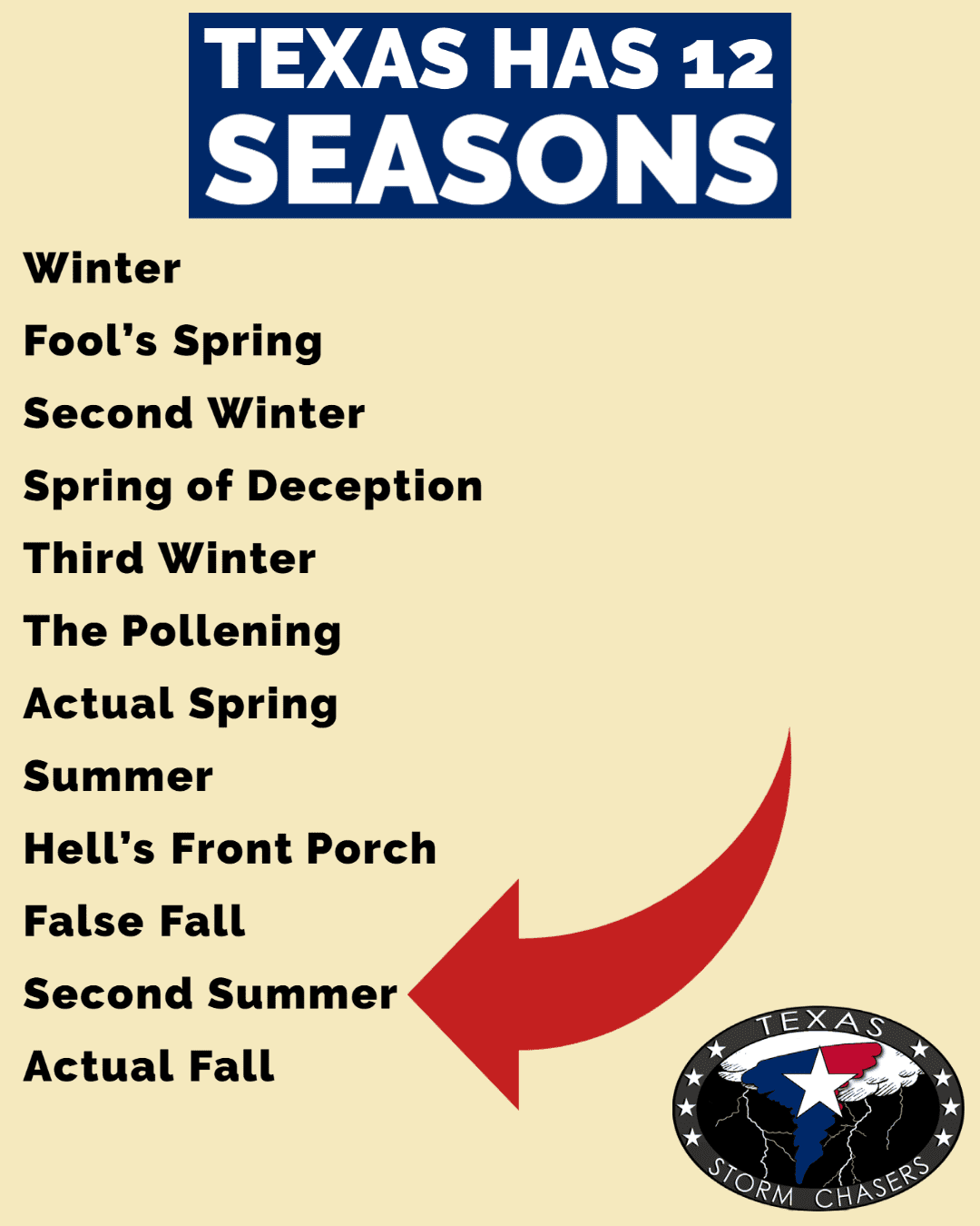
Welcome to another Friday and a special Friday at that. We’ve got a big weekend ahead in the Sports department, we’ve got outdoor events galore, and we’ve got record heat. Yeah, I’m sorry about the heat. It may be October, but the next two days will feel like mid-August across Texas. Forget fall weather, we’re in the second summer, and it will be hotter than a deep-fried gumbo ball at the State Fair. I’m not sure if the fried gumbo balls are spicy, but they sure are popular this year.
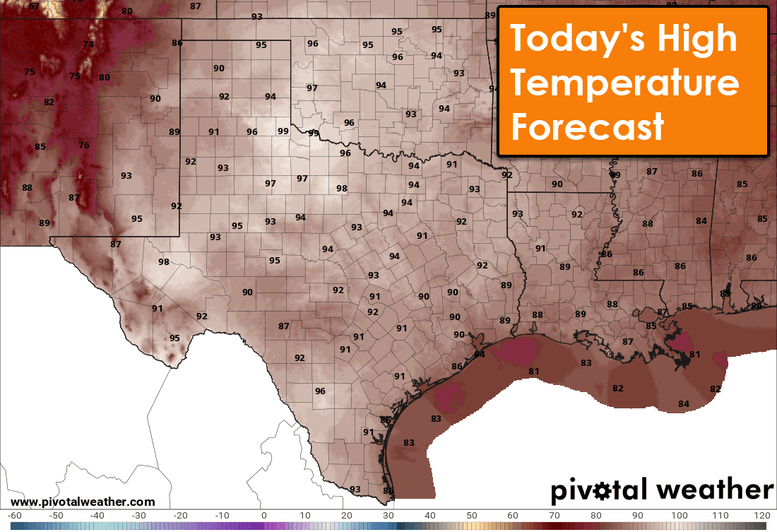
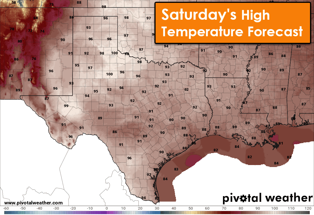
High temperatures across Texas this afternoon will be well above average for October. We’ll see peak temperatures well up into the 90s, with triple-digit temperatures possible in the Permian Basin and Northwest Texas. Saturday will be even hotter across much of Texas. High temperatures are expected to peak in the middle and upper 90s – with more triple digits across the Permian Basin, Northwest Texas, into the eastern Texas Panhandle.
While it will be toasty, we’re still enjoying a dry airmass with low dewpoint and humidity values. That’ll change quickly by Saturday Night and on Sunday as strong moisture return occurs ahead of an arriving upper-level storm system.
Sunday
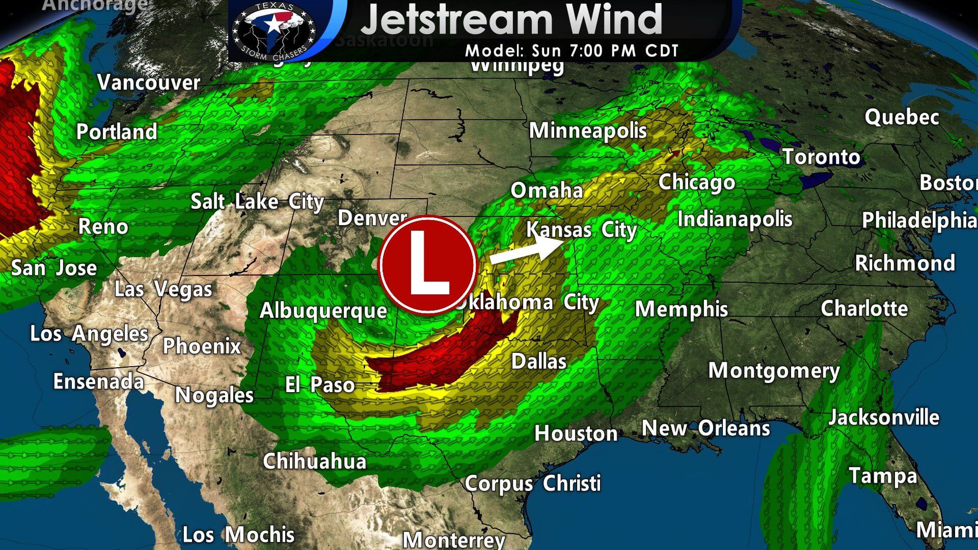
A deep upper-level trough will move out of the Southwestern United States and into our neck of the woods on Sunday. Jetstream-level winds around 18,000 feet above sea level will approach 100 miles per hour out of the southwest. Closer down to the surface, a dryline will take shape and move east. By late Sunday afternoon, the dryline should be near or a bit east of Highway 281. Hot and windy conditions are expected west of the dryline on Sunday – with critical fire danger. Strong southerly/southeasterly winds and increased humidity will be present east of the dryline.
A strong capping inversion will keep a lid on the atmosphere for much of the afternoon on Sunday. As the upper-level storm system arrives along with the surface dryline and cool front, we’ll likely see the capping inversion break late Sunday afternoon. Timing on initial thunderstorm development is still up in the air, but we’re going with around 5 to 6 PM (especially north of the Red River in Oklahoma). South of the Red River, we may have to wait a bit longer – and its possible storms may not fire until around sunset.
By late Sunday evening, strong ascent (lift) should cause the initial discrete thunderstorms to grow upscale into a squall line. Storms may ‘unzip’ further south along the dryline Sunday night. The southward extent of thunderstorm development will have to be refined in upcoming forecast updates. In the form of a broken squall line, scattered thunderstorms may move east across North Texas, Central Texas, the Hill Country, and Northeast Texas late Sunday and early Monday.
Sunday’s Severe Weather Setup
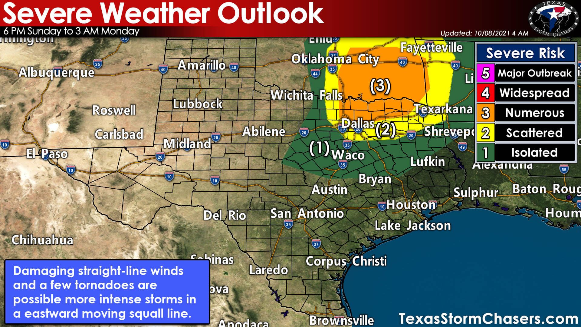
Severe thunderstorms are likely Sunday evening in Eastern Oklahoma, Texoma, and Northeast Texas. The risk for severe storms does include North Texas, with the highest potential east of Interstate 35W and north of Interstate 20. A more isolated severe weather threat may extend south into Central Texas and the Brazos Valley Sunday Night. The Storm Prediction Center has highlighted a level three out of five risk for severe storms from the northern D/FW suburbs north into eastern Oklahoma.
The enhanced severe weather risk includes portions of Texoma and Northeast Texas. The potential for severe storms decreases south of Interstate 20 but can’t be ruled out. Any severe weather risk level means there is a chance for strong to severe thunderstorms. Don’t get hung up on the exact line placement or the risk names. The risk levels are based on the probability of a severe storm occurring within 25 miles of any given point (like your home). We’ll likely see the risks adjusted as we get closer to the event.
Threats
The most intense thunderstorms may produce damaging straight-line winds over 60 miles per hour. Strong low-level wind shear will be present, so there will be a risk for a few tornadoes. We’ll also have to watch the squall line late Sunday night for brief spin-up tornadoes embedded within areas of damaging straight-line winds.
Sunday’s severe weather setup is a ‘high shear-low instability type of event. We don’t typically have to deal with destructive hail, but we’ll probably still have some storms that produce hail up the size of quarters or even golf balls. The hail threat will be highest in the initial discrete thunderstorm development – before storms grow ‘upscale’ into a squall line.
Consider this a heads up and reminder that we do have a fall severe weather season in Texas. Take the time over the next couple of days to review your severe weather safety plans while the weather is beautiful. It is always better to plan while the weather is nice versus when the sirens are blaring, and I’m barking out your town in our digital tornado coverage.
Monday
We are going to be in-between storm systems on Monday. Our first upper-level storm system will be moving toward the Great Lakes. Meanwhile, a more impressive upper-level storm system will be taking shape on the West Coast. While a few showers may stick around during the afternoon, I’m expecting the second half of Monday to be quiet in the weather department.
Tuesday and Wednesday
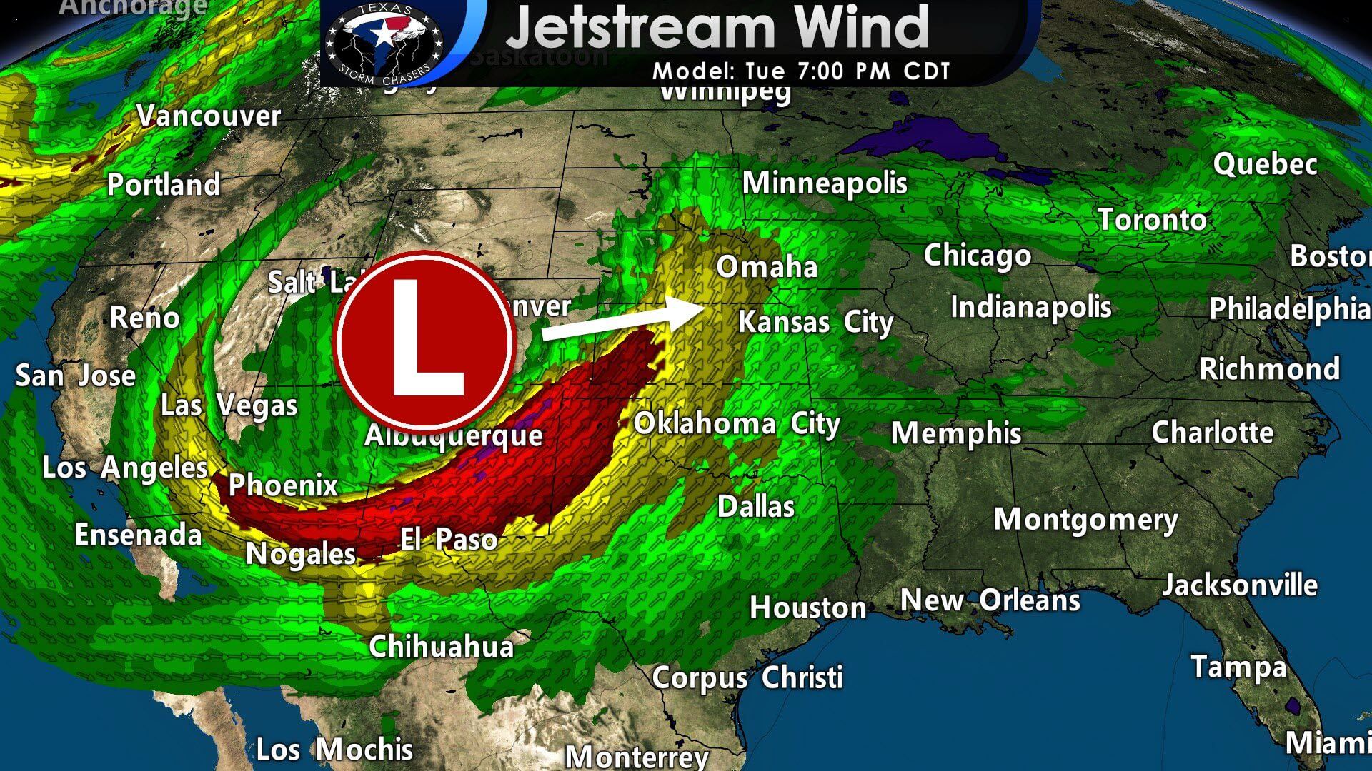
A powerful upper-level storm system will bring another chance for severe thunderstorms to Texas on Tuesday and perhaps Wednesday. We’ll deal with this second storm system once we get past Sunday. I do anticipate we’ll be rather busy at times on Tuesday and Wednesday. Synoptically speaking (large-scale weather and recognition of past weather events), the Tuesday/Wednesday upper-level storm system has severe weather potential written all over it. Luckily, we’re five days away, and we’re simply playing with weather model data. That data will change, so there’s no point in becoming specific on threats/timing/risk zones just yet.
Our Storm Chasing & Coverage Plans
We’ll likely have storm chasers out in the field on Sunday. Live storm chasing video is also a decent possibility, though we’ll have to see if it ends up being an ‘after dark’ event. I’ll be in the office to provide digital severe weather coverage. As usual, if we have a tornado warning in Texas, I’ll do my best to provide continuous live video coverage. All of the above goes again for Tuesday and Wednesday. Be sure you’ve downloaded our free mobile app so you can stay in the know!


0 Comments