
A tropical wave continues to produce a large area of disorganized showers and thunderstorms in the southwest Gulf of Mexico. Upper-level winds are not conducive to development today. However, that will change on Sunday and Monday as the system moves to the north/northwest. A tropical depression and eventually a tropical storm is likely to form over the next few days. If the system does indeed become a tropical storm, it will likely be named Nicholas.
I want to be clear that regardless of the system’s eventual tropical fate, the most widespread weather hazard will be in the form of heavy rain. We’ll go over the rain possibilities below.
Storm Surge, Wind, and Tornado Threats
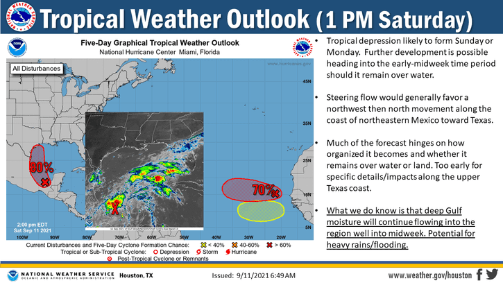
Limited impacts from strong winds, storm surge, and tornadoes may occur on the Middle and Upper Texas Coast on Monday and Tuesday. The specific location of any tropical-cyclone impacts will depend on the track of ‘Nicholas’ along with the intensity. Some weather models do try and bring Nicholas up to 50-60 MPH winds before landfall. Still, hurricane intensity is not expected as of now. Nevertheless, we’ll keep an eye on the data since we’ve seen our fair share of rapid organization from the tropical spinnies lately.
Our current expectations are for minor coastal flooding along the Texas Coast as the system moves northwest before turning north and eventually northeast next week. The specific track and intensity will dictate the more localized threat for tropical-storm-force winds. If the system tracks further east, the threat for tropical-storm-force winds may be confined to the Upper Texas Coast and Southeast Texas.
Before turning north/northeast, a track farther west would extend the threat for stronger winds further southwest along the Middle Texas and South Texas coast. Again, we’re not expecting a hurricane at this time. The strongest winds from the system would be confined to stronger squalls in the northeastern quadrant. A few tornadoes would also be possible in the northeastern quadrant of the system.
Heavy Rain and Flooding Threat
Unlike the spatially limited hazards discussed above, the chance of rain will not depend as much on the system’s track. We’re expecting several days of wet weather along the Texas Coast and in adjacent inland regions. Very high amounts of moisture will move inland ahead of the upcoming storm system. All that moisture means where it rains – it will be on the heavy side.
As usual, the closer to the coast one is located – the more rain is forecast. If future data suggests a further south/east path with the system, the heavier rains may shift to Louisiana. A west/north shift would bring heavier rains further inland. The current weather model data shows 15 to 25 inches of rain falling just off the Southeast Texas coast out in the Gulf of Mexico. Fourtinietly, there is a sharp decrease in rain totals to the west/northwest of the system’s projected track.
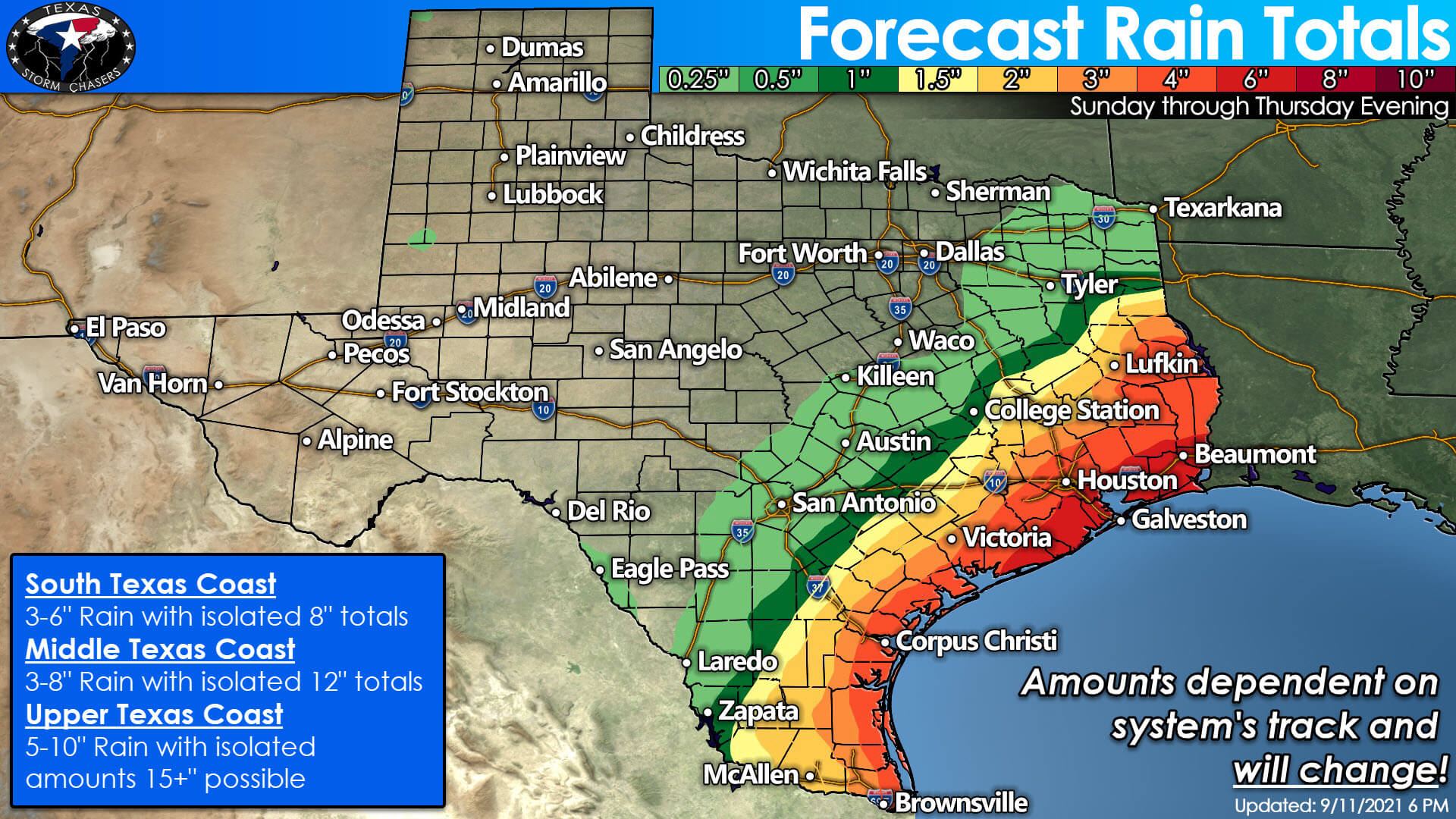
Rainfall amounts will trend downward the further northwest one gets from the system – with the highest rain totals to the northeast and east of the system. If the system trends more to the west, the higher rain amounts will shift into Southeast Texas and the Golden Triangle. A shift to the east would reduce projected rain totals inland from the coast and help keep the 10+ inch rain totals right on the Upper Texas Coast or just offshore. We’ll have to wait until the system actually ‘forms,’ and we can gain confidence on the track of the system. Localized significant rainfall amounts will be possible, potentially resulting in areas of flash and urban flooding.
Keep an eye on the system with our Tropical Weather Dashboard by clicking here. We’ll keep tuned into the trends and likewise keep y’all updated too.


0 Comments