
Congratulations on making it to the end of another work week! We are starting the morning with a relatively widespread band of rain across West-Central Texas. More isolated showers and thunderstorms are moving east across Texoma in association with an outflow boundary. The summer of rather unusual weather continues – since I am not typically discussing widespread rain in West Texas in mid-July. We will take it, in any case!
Today
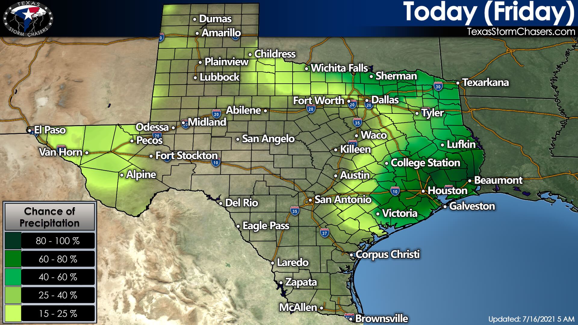
Like yesterday, scattered tropical downpours are expected across Southeast Texas, the Brazos Valley, and East Texas today. The highest chance for a downpour will be from mid-morning through dinner-time. Not everyone will get rained on, and it certainly will not last all day. As usual, stronger popup storms may produce frequent cloud-to-ground lightning, localized gusty winds, and a quick two to three inches of rain. Storms will start dying off as we get toward dinner-time and into the evening hours.
A storm or two is also possible this afternoon in the Borderland and Far West Texas (West of a Pecos to Alpine line). Any storm out there could result in gusty winds and blowing dust. Finally, as if that was not enough for mid-July, we also have to take a look at Texoma and North Texas. An outflow boundary produced by storms last night in West Texas has moved east into Texoma this morning. New thunderstorms may develop this afternoon and early this evening near that boundary – which should be located in Texoma and North Texas.
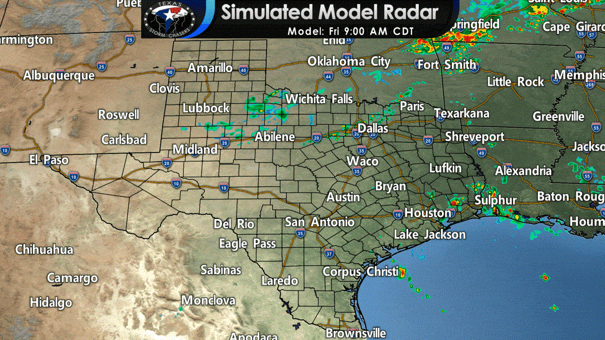
The simulated weather model radar shown above is on the aggressive side of popping up those storms today. We will see if the HRRR model is correct or if it is overzealous. It is July, so any summer storms that get going could be on the rowdy side with gusty winds, small hail, a quick round of heavy rain, along with more than enough lightning to get the pets skedaddling under the bed.
Tonight
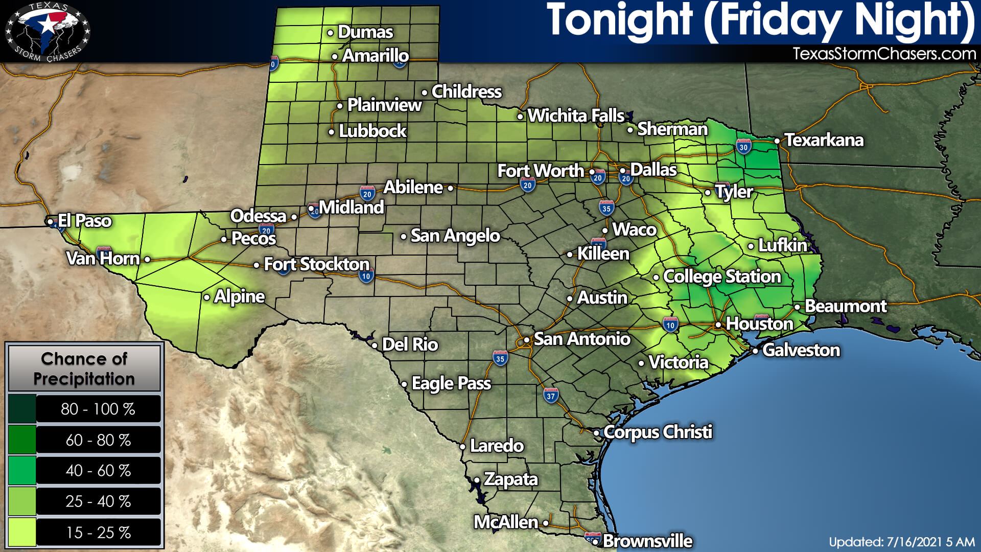
Our daily ‘popcorn’ storms in Southeast Texas should be primarily out of the picture by 9 PM. We may hold on to isolated storms in North Texas and Texoma through midnight. A cluster of thunderstorms may fire up in Oklahoma this afternoon. Should an organized thunderstorm cluster materialize, those storms may move southeast toward the ArkLaTex and Northeast Texas tonight. We will have to keep an eye on the trajectory of those storms to see if they head into Arkansas or pay a visit to Northeast Texas late this evening.
Saturday into Saturday Night
Saturday will feature a few chances for thunderstorms during the day, just like most days this week. The highest chance for a tropical downpour will be in Southeast Texas and the Golden Triangle (Beaumont area). Some weather model guidance suggests a drier airmass may arrive tomorrow afternoon, lowering rain chances for those two regions. We will keep an eye on it. Otherwise, slightly higher rain chances than today are expected in the Borderland (El Paso) east into the Trans-Pecos and higher elevations to the southwest (Pecos, Alpine, and Van Horn). Isolated storms are possible late tomorrow afternoon in the Texas Panhandle and West Texas. However, they are more likely tomorrow evening as activity moves southeast from Colorado and New Mexico. Organized severe weather is not forecast at this time.
Sunday into Next Week
Sunday’s rain chances will be primarily confined to Southeast Texas, East Texas, and the ArkLaTex with tropical downpours possible. Increased monsoonal flow across New Mexico may allow isolated storms to visit the Panhandle and Far West Texas. We will take a closer look once we get into tomorrow, but widespread severe weather is not expected. As we head into next week, our weather across Texas will become more active (not that typical for mid-July, but hey, what is ‘normal’ these days?).
A cool front will mosey on south into Texas on Monday, Tuesday, and Wednesday. Scattered to numerous showers and storms are likely each day – progressing further south as we head into mid-week. A few strong storms with hail and gusty winds may occur, but widespread severe weather does not look likely due to weak upper-level winds. Locally heavy rain may become an issue, especially since we are still dealing with saturated soils. Anyway, all that rain and increased cloud cover will result in cooler daytime high temperatures.
On the bright side? All this weather is keeping the tropics behaved, at least in our little stretch of the world.
Little note from Baldy-In-Chief
You might notice we are not discussing the heat or temperatures very much. I figure we all know it is toasty during the summer in Texas. We may not be dealing with record heat, but it is still toasty and humid. Frankly – it gets boring talking about that day after day after day. Once I finish putting together our standard temperature map templates, I will try to get back into sharing forecast high and low temperatures.
You can keep an eye on the sky with our free interactive weather radar here on our website. Better yet? Check out that same radar but within our free mobile app. Do not rely on social media to find out when we post new weather forecasts – get that information sent straight to your phone! I believe our forecast articles reach about a fifteenth of one percent of our total Facebook following on average. That is why we do not rely on a single social media platform versus posting content directly to our website.


0 Comments