
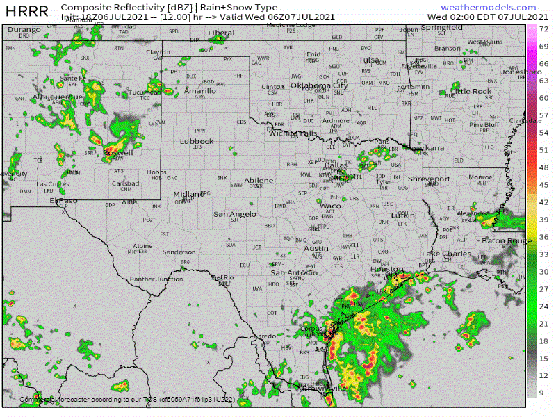
Simulated weather model radar from the early afternoon run of the High-Resolution Rapid Refresh (HRRR). This simulated radar shows what the radar may look like at times on Wednesday through Thursday morning.
Active weather continues to bring rain chances and below-average temperatures (for July) to parts of Texas this week. Our focus for the next two to three days will be in the Rio Grande Valley, South Texas, Middle Texas Coast, and the Coastal Plains. An upper-level low centered over South Texas will bring enhanced lift and an on-shore flow. Those on-shore winds will pump tropical moisture into multiple rounds of heavy storms near the coast beginning tonight and continuing through at least Thursday.
Big rains over northwest San Antonio this morning
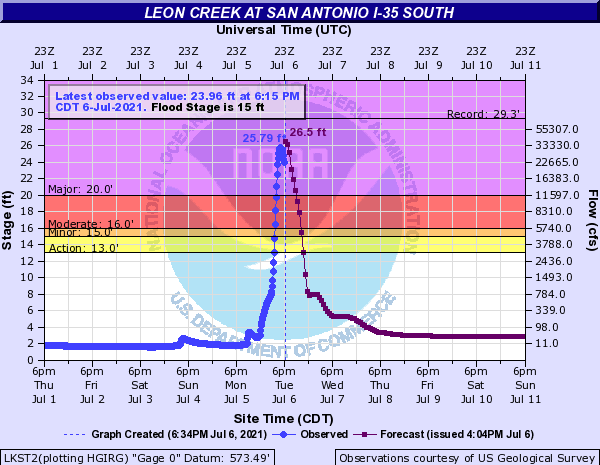
One round of heavy thunderstorms dropped over seven inches of rain in a few hours this morning in northwest San Antonio. That heavy rain over an urban area resulted in the Leon Creek in south San Antonio rising from two feet up to nearly twenty-six feet this afternoon.
The gauge at Interstate 35 and Leon Creek recorded its fourth-highest water level on record (dating back several decades). Major flooding resulted in Interstate 35 briefly being closed and numerous structures being flooded across the surrounding area. Those kinds of issues are expected in other portions of the Middle Texas Coast and Deep South Texas at times over the coming days as additional heavy storms drop torrential rainfall.
Forecast Rain Totals through Friday
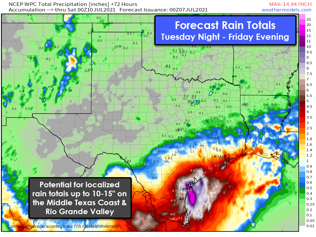
We’re anticipating widespread rainfall totals across South Texas and the Rio Grande Valley through Friday evening between two and four inches. Isolated higher rain totals exceeding six inches will be possible. More substantial rain totals are expected from Port O’Connor through Corpus Christi to Port Mansfield and into the Rio Grande Valley.
Widespread rain accumulations could range between five inches all the way up to fifteen inches. There will be sharp gradients between ‘just five inches of rain’ and the ten to fifteen-inch totals like today in north San Antonio. Regardless, where we have heavy rain bands set up over the coming days, we could see more than three inches of rain per hour.
If those heaviest rain bands set up over an urban area (McAllen-Brownsville and Corpus Christi, for example), we would see significant flash flooding develop rapidly. If those heaviest rain bands set up just off-shore, well – it’ll be quite a light show. It will not constantly rain over the next three days. We’ll see breaks in-between waves of heavy rainfall.
Flash Flood Outlook for Wednesday & Thursday

There is a moderate risk of flash flooding on Wednesday across the Middle Texas Coast, South Texas, and the Rio Grande Valley – including Corpus Christi, Brownsville, and McAllen. Comparatively lower flooding risks exist north to Interstate 10 in Southeast Texas (Houston) to South-Central Texas (San Antonio) west to Eagle Pass. I anticipate the Moderate Risk for flash flooding will continue into Thursday across the same regions, perhaps extending further northeast along the Upper Texas Coast.
The highest risk for considerable, locally life-threatening flash flooding will be near the immediate coastline. Flash flooding could consist of street flooding and rapid rises on creeks/streams. Longer-term flooding (in the days afterward) could consist of flood waves moving down rivers. We’ll also need to watch for coastal flooding due to on-shore winds on Wednesday and Thursday, especially along the Middle Texas Coast.


0 Comments