
Yesterday’s severe weather outbreak brought numerous reports of large hail, damaging wind gusts, and a few tornadoes to the Texas Panhandle, West Texas, the Permian Basin, and Concho Valley. Overnight, we had a bow echo move across South Texas, resulting in wind damage and a few tornado warnings around Alice and Orange Grove, east to Robstown and Kingsville. At the time of this writing, we were monitoring a small line of storms approaching San Angelo. Those storms in the Concho Valley should weaken by the time this post is published.
Meteorologist Jason Cooley, Alex Bartholomew, and Stephen Jones documented a large tornado north of Sterling City last evening. Sterling City is located southeast of Big Spring and northwest of San Angelo. The tornado did impact a manufacturing facility on Highway 163 north of Sterling City. We’ve got their video embedded above. We were able to stream it live on our YouTube channel and in my own severe weather coverage on our digital platforms.
Anyhoo, let’s get on with the upcoming weather forecast. Several days of unsettled weather remain in the forecast for much of Texas. Some severe weather chances are evident, but the more widespread weather hazard will be heavy rain and flooding. Weather models, including the typically reliable high-resolution ones, are struggling big-time with the current weather pattern. The issue is we have a tropical air mass along with a nearly stationary upper-level storm system.
Surface boundaries, leftover from prior storms, can muddle up the surface weather pattern. Those boundaries are also sources of lift and can help new storms fire. Most weather models are not going to pick up on all those features. All of that is to say our confidence in a specific forecast solution is low. We’re confident it will rain and that there will be multiple rounds of rain over the next several days. Trying to pinpoint specific corridors of enhanced heavy rain, flooding, and severe weather potential is more difficult.
With my whining complete, let’s see if Mother Nature will be kind enough to let me not make a fool of myself (not likely). Thunderstorms underway this morning in the Concho Valley should weaken severe limits by 6-7 AM. Activity may not dissipate, however. Scattered showers and storms could continue through the mid-morning hours in the Big Country, Concho Valley, and western North Texas. Some of those storms may briefly pulse up and produce gusty winds.
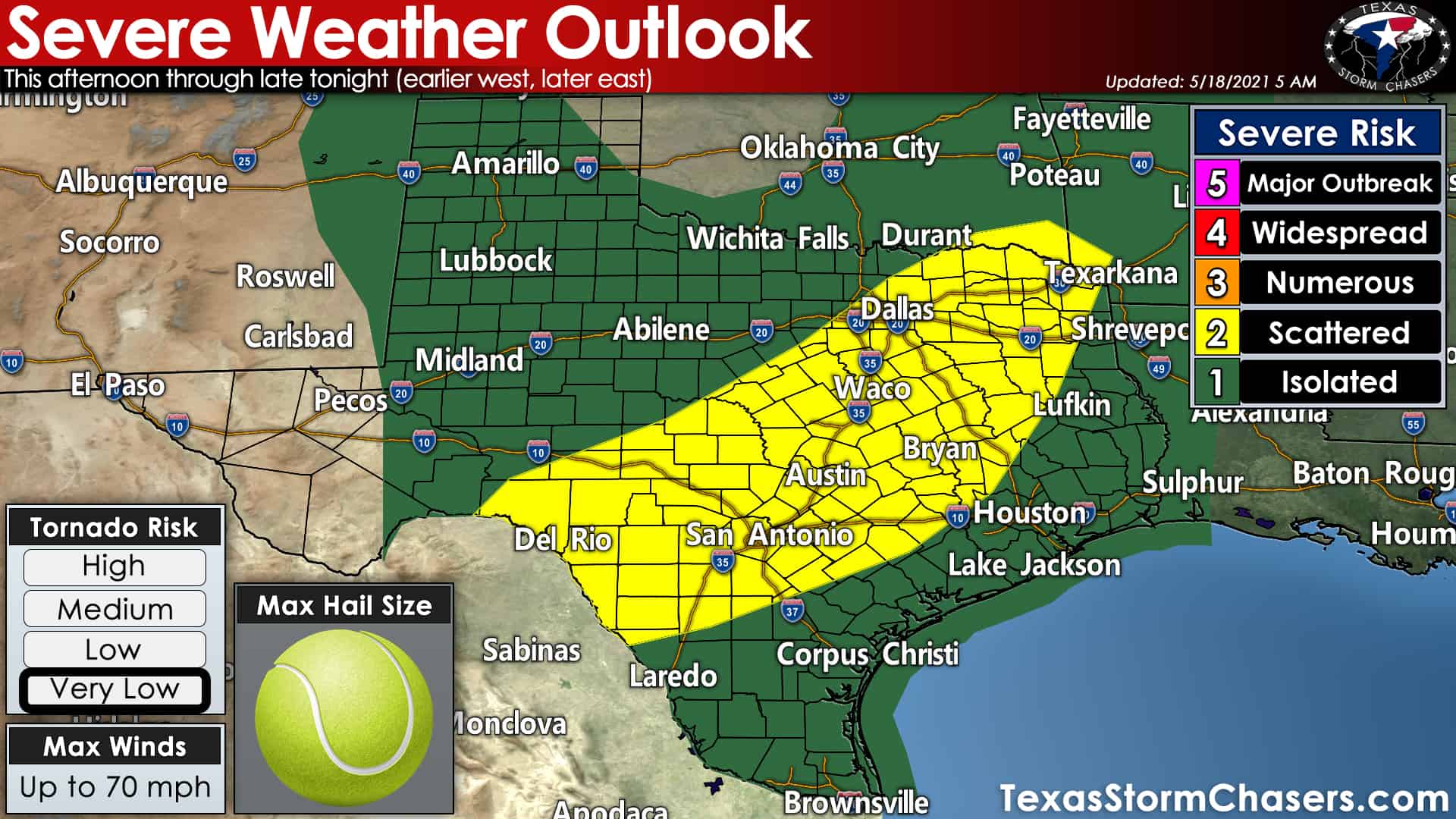
Today’s severe weather outlook from the Storm Prediction Center
As we get into the afternoon hours and the atmosphere across Texas destabilize, we should start to see new activity develop in several regions. Scattered storms across East Texas and Southeast Texas will produce heavy rainfall, lightning, small hail, and gusty winds. Further west into the Hill Country and eastern Concho Valley, thunderstorms will start intensifying again. Some storms may become severe with large hail and damaging straight-line winds.
We may see storms grow upscale into a cluster or line. Assuming a thunderstorm cluster develops, those storms would start moving east, moving east toward Central Texas. They may not move all that quickly and will be dumping buckets of rain. Flooding could become a problem under any slow-moving storm today. Today isn’t a classic spring severe weather setup. Yet, tropical moisture and a little bit of heat will allow the atmosphere to destabilize. Our stationary upper-level storm system will provide wind shear aloft.
Moisture, instability, and wind shear aloft will favor more organized storm modes at times. Low-level wind shear is weak today, but like yesterday, any supercelluar storms that start interacting with outflow boundaries could produce a tornado. Today’s tornado threat is lower than yesterday but is not zero across the eastern half of Texas. It is a wait-and-see sort of day, just like tomorrow will be. Most folks won’t be dealing with severe storms today.
One or more clusters of slow-moving storms could be in North Texas, Central Texas, the Brazos Valley, Northeast Texas, and East Texas this evening. Stronger storms may produce some hail and gusty winds. All storms will produce heavy rainfall – some producing two to four inches of rain per hour. We’ll need to watch for slow-moving storms ‘training’ or moving over the same areas. That scenario would result in some locations receiving 2-4 inches of rain per hour for several hours. Flooding would likely result, so we’ll keep a close eye on trends for clues on where that may happen tonight.
Overnight, thunderstorms are likely across the Concho Valley, Hill Country, North Texas, Central Texas, the Brazos Valley, East Texas, and Northeast Texas. Heavy rain is expected, with some locations receiving over six inches of rain tonight. The worst-case scenario would involve small zones of 8-10 inch rain totals in six hours tonight. Exactly where the corridors of very heavy rain set up will depend on where outflow boundaries set up tonight – and where we have storms set up shop.
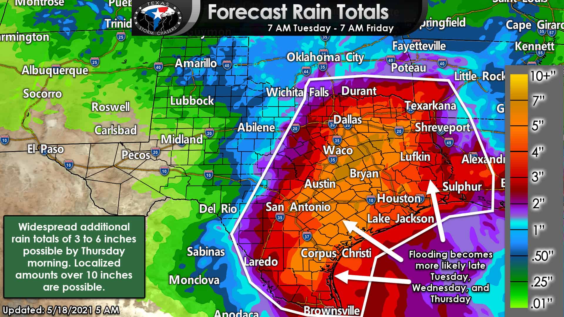
Forecast additional rain totals through Friday morning from the Weather Prediction Center. Isolated rain totals over 10 inches are possible.
Everything I just described for tonight will continue tomorrow but slowly shift south with time. That is how we expect widespread multi-inch rain totals extending all the way to the coast in South Texas and Southeast Texas by Wednesday night. Keep in mind; some folks have already seen over 10 inches of rain over the last few days. We’re talking about adding another 4-12 inches on top of that. Not everyone will have to deal with super heavy rain or flooding. Yet, I believe we will have to deal with some serious flooding problems over the next 36-48 hours. Moderate to major flooding will also be an issue well into next week (more like into June) across several river basins across the eastern half to the eastern two-thirds of Texas.
Notes and useful links
That’s about it, folks. I’ve done my best to convey our latest thoughts. I realize I spent more time explaining why the forecast is so difficult this week. We’ll have folks out chasing again today and should be live streaming their video. Once their live video is available, it’ll show up on our homepage and our YouTube channel. Assuming I’m not driving to Abilene to rescue a few storm chasers who blew their rear differential yesterday, I’ll be providing digital weather coverage this afternoon and tonight. The best way to get real-time updates is via our Twitter account (which you can also find here without leaving our website). Our Texas Interactive Weather Radar will be useful for tracking the storms.


0 Comments