
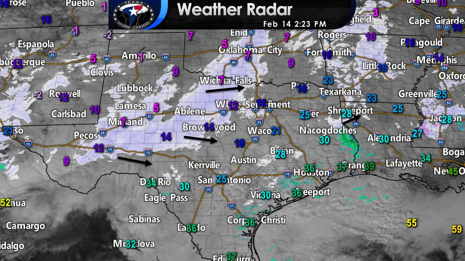
A relatively large snow area is falling across Northwest Texas, the Big Country, the Concho Valley, and in the Permian Basin. We have light freezing drizzle or light snow across Central Texas, the Brazos Valley, the D/FW Metroplex, and Northeast Texas. For now, we’ve got light rain showers across the Coastal Plains and north of Beaumont. Several inches of snow have accumulated across the Texas Panhandle, West Texas, and in the Borderland (Far West Texas out around El Paso). The large area of snow will continue moving east and also expand southward tonight.
You can keep up with the winter weather with our free interactive weather radar here on our website. Those using our free mobile app can click the ‘radar’ button on the bottom menu. Want our free mobile app? Download it here.

Simulated weather model radar from 3 PM this afternoon hourly through 9 AM Monday.
The High-Resolution Rapid Refresh model has been doing a decent job today. If anything, we’ve noted the eastward progression of the snow band slowing. However, a heavy snow band will move east into the D/FW Metroplex soon with near blizzard conditions. Precipitation will expand east and south tonight as the upper-level lift increases. The southeastern half of Texas has remained relatively quiet so far today.
There has been a freezing drizzle, but we’re going to see moderate to heavy sleet and snow. Freezing rain with ice accumulations is forecast across South Texas and the Rio Grande Valley. Freezing rain and sleet will start the show in the Brazos Valley, Central Texas, South-Central Texas, and Southeast Texas later today. That mixed bag of winter mischief should switch over fairly rapidly to snow. Several inches of accumulating snow, on top of a thin layer of ice, is forecast. Precipitation will slowly end from west to east tonight. We should be precipitation-free by 9 AM Monday. However, accumulations will likely not melt quickly as surface temperatures remain well below freezing for the northern seventy-five percent of Texas through Tuesday.
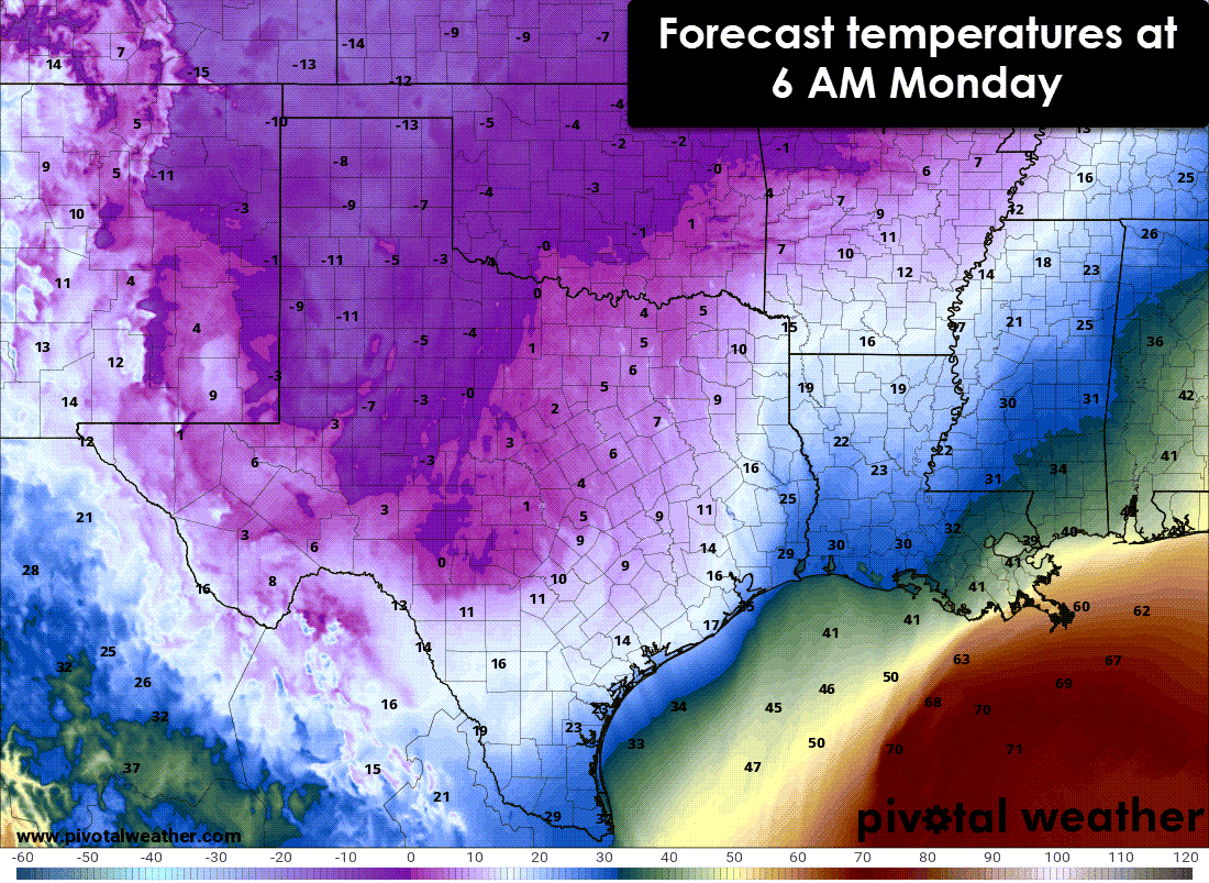
Forecast temperatures at 6 AM Monday
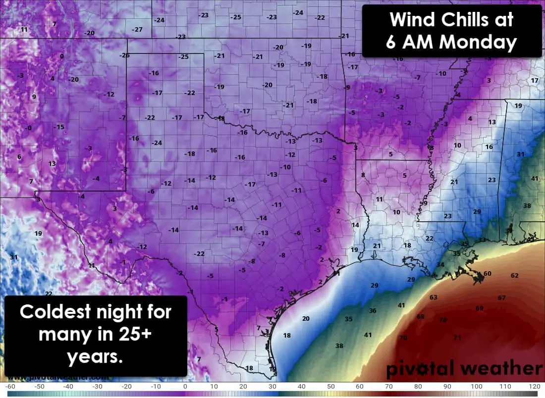
Forecast wind chill temperatures at 6 AM Monday
We’ve trended a bit quicker with the snow transition, so that raises snowfall amounts tonight in southern North Texas, the Brazos Valley, and parts of Southeast Texas. Some folks could see over six inches of snow tonight in the aforementioned regions. I apologize for the lack of new forecast accumulation maps; this is such a dynamic and large-scale event that we can’t keep up. This will be a historic winter storm. Regardless of specific accumulations for specific locations, the entire state will have received accumulating snow, sleet, and/or ice by sunrise tomorrow. Travel will be hazardous, and brutally cold air will be in place. For many locations, tonight will be the coldest night since 1989-1996.


0 Comments