
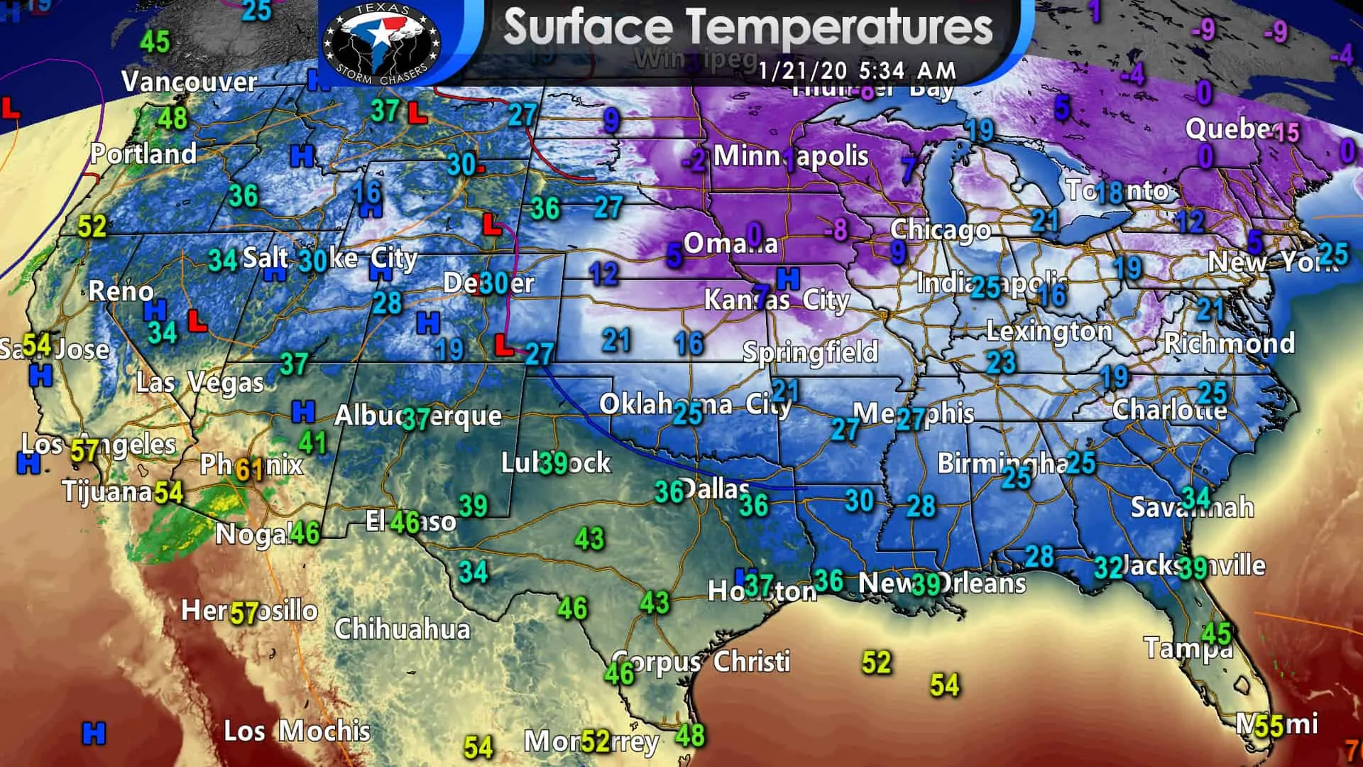
Surface temperatures around 5 AM this morning across the United States. All images in this post may be clicked on for a larger version.
We’re starting off on the cool side this morning, but temperatures are much colder just to our north and east. Rain is falling this morning over southern Arizona. That precipitation mass will expand as it moves eastward into New Mexico later this morning.
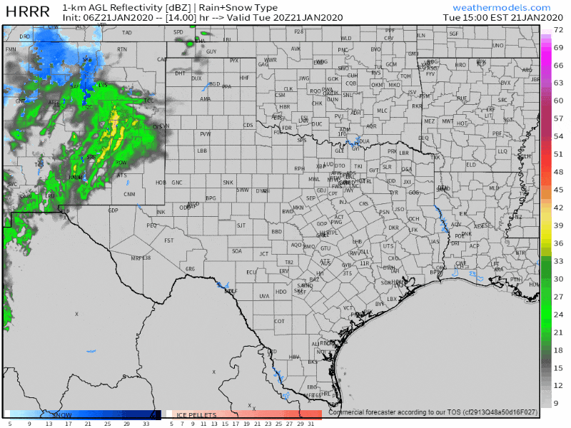
1/21/2020 06Z HRRR | Simulated weather model radar beginning at 2 PM CT today and continuing until 12 PM CT Wednesday. The animation progresses forward two hours per frame. Times can be located on the top-right part of the graphic. All images within this post may be clicked on for a larger version.
Rain will begin moving into the Borderland (El Paso area) around 1 PM mountain time this afternoon. Farther north, we anticipate rain will arrive in the western fringes of the Texas Panhandle and West Texas around 3 PM CT. A broad band of light to moderate rain will then move from west to east across nearly all 254 counties in Texas by Wednesday afternoon. Some locally heavy rain is possible, but this isn’t a flooding setup nor one that will produce severe thunderstorms. Getting caught out in the cold rain or finding a flooded bar ditch is about the worst we expect from this round of precipitation.
Rain will move east into the I-35 corridor from the Red River to San Antonio around midnight to 2 AM tonight. Winter weather and severe weather are not expected, but it’s going to be chilly and wet. Traffic should be about as pleasant as going to the doctor for blood work. (Hint: I don’t like needles, so that should give you a hint on how I expect tomorrow morning’s traffic to unfold).
We’ll see rains move into Tyler south to Houston between 5 AM and 7 AM Wednesday. Showers look to move in from the west/northwest into Corpus Christi around 7 AM to 9 AM. Those south in the Rio Grande Valley will probably have to wait until the early afternoon before scattered showers move in from the north.
Snow in Northeast Texas tomorrow morning
Wait, there’s more! A brief rain/snow mix may occur in the Texas Panhandle this afternoon. However, we are comparatively more confident in a short period of wet snow occurring in Northeast Texas Wednesday morning. The process of getting wet snow before changing over to rain was explained in detail yesterday morning. I’ll go ahead and include that snippet in today’s blog for those who missed out. If temperatures are even a bit warmer, we’re going to see only rain.
As precipitation begins to fall in a dry airmass, it evaporates – and that process acts to decrease temperatures and increase moisture. When surface temperatures are in 35-38 degree range, and evaporative cooling takes place, we can sometimes see temperatures drop to 32-34 degrees. Evaporative cooling can result in precipitation falling as snow instead of rain, at least initially.
Even if evaporative-cooling potential Wednesday morning in Northeast Texas, we’ll still see any snow change back over to rain after one or two hours. Minor accumulations of wet snow cannot be ruled out on grassy surfaces *if* the scenario, as mentioned above, plays out. However, the changeover to rain would quickly melt any snow accumulations.
Minor accumulations of slushy snow seem plausible in far Northeast Texas tomorrow morning from 5 AM through 9 AM. Surface temperatures should remain right at or just above freezing. Travel impacts, outside of those we typically see in wet weather, are unlikely with warm road surfaces. Any snow accumulation on grassy and elevated surfaces should melt quickly after the snow switches over to rain. Enjoy any snow while you can because it won’t last long! The lucky folks could see between a dusting to one-half inch of slushy snow briefly accumulate. We should be back in an all-rain precipitation type by 10 AM.
Scattered showers and perhaps an isolated thunderstorm will continue Wednesday afternoon through Wednesday night near and east of Interstate 35 from the D/FW Metroplex south to San Antonio – east to the state line. Rain intensity could increase Wednesday night as a second quick-hitting upper-level storm system skirts by. Isolated flooding could occur in Southeast Texas tomorrow afternoon through Thursday morning.
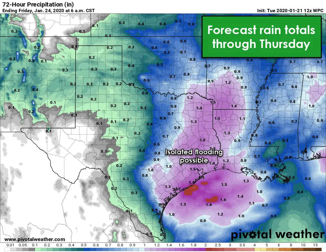
Forecast rain totals through Thursday from the Weather Prediction Center.
Rain chances will end by early Thursday afternoon in Texas. We don’t have any arctic airmass arriving behind Thursday’s system, so temperatures will remain near January averages with clearing skies Thursday from west to east. Pleasant weather and near average temperatures, perhaps a bit above, are expected through the weekend. No nasty weather for the weekend in Texas! Active weather may return to Texas around Tuesday or Wednesday of next week.


0 Comments