
I’m going to crank this morning’s discussion out a bit early so I can get a few hours of shuteye before gearing up later today. There have not been any significant timing changes with the severe weather threat today. If you read my discussion last evening, you’ll find this one should be somewhat similar in regards to the timing. This morning will remain quiet in the severe weather department. Spotty showers and perhaps an isolated thunderstorm are possible. However, a capping inversion will keep a lid on things through lunch-time.
Click on the image for a larger version.
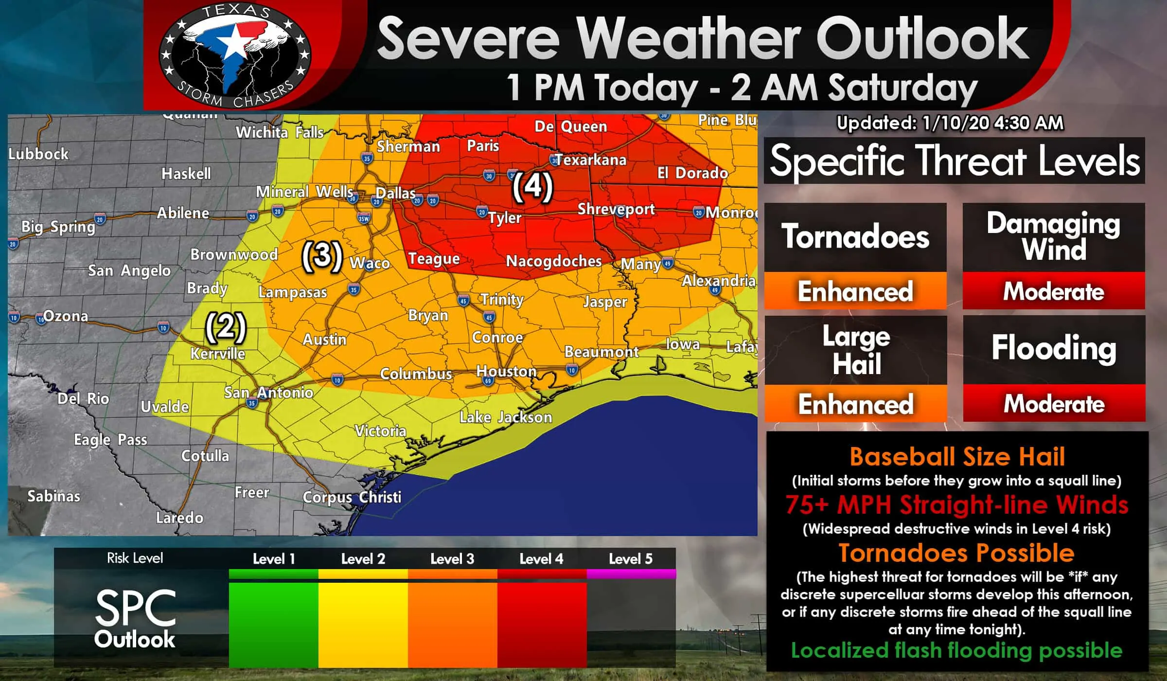
A significant severe weather episode is expected to unfold across portions of Texas later this afternoon and into tonight. A level four out of five risk of severe weather encompasses all of Northeast Texas, parts of East Texas, and eastern North Texas. An enhanced level three risk of severe weather includes much of Texoma, North Texas, Central Texas, all of the Brazos Valley, Southeast Texas, and the Upper Texas Coast.
Please don’t get hung up on the risk terms or line placements. The severe weather threat from the strongest storms will be the same regardless of the risk zone. Folks in the level 4 risk have a higher chance of experiencing widespread damaging straight-line winds, some of which may be hurricane-force. A level two risk of severe weather does include South-Central Texas and the Coastal Plains. A few severe storms are possible in those regions. Still, the number of severe thunderstorms should be lower in comparison to farther north and northeast.

Click here to download the free TSC mobile app
Exact line placements could shift some through the day, but by early afternoon we’ll be at the point where we change from ‘forecasting’ to the ‘watch’ phase. That’ll also mean we’ll start shifting into more of a ‘rapid-fire’ update phase where we utilize our Twitter account @TxStormChasers. Those without a Twitter account can still monitor our updates here on our website and in our free mobile app. Our app also has free HD interactive weather radar and will include our live video coverage later today. You can also access our free HD interactive weather radar here on our website.
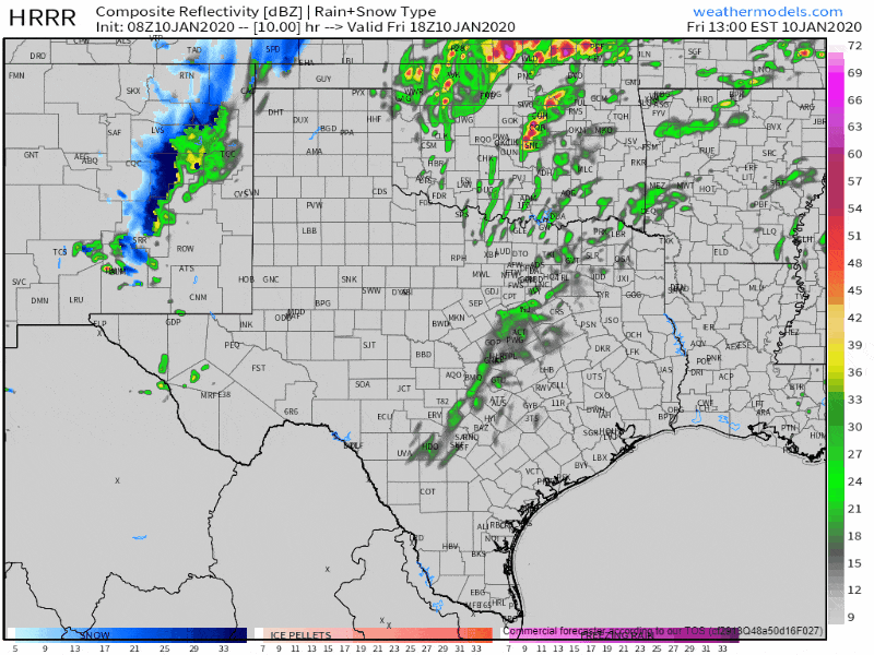
A simulated weather model radar from the HRRR beginning at noon today through 5 PM. Click on the image for a larger version.
The first thunderstorms of the afternoon could be developing by 2 PM in North Texas – generally from near Sherman to the D/FW Metroplex, southwest into the Hill Country. It appears probable we’ll see thunderstorm coverage quickly increase by 4 PM in Texoma southward into North Texas – including within the D/FW Metroplex. The strongest storms could be capable of producing localized damaging wind gusts over 60 MPH, heavy rainfall, and perhaps a tornado threat.
Very large hail could also occur with initial storms. Individual storms will move northeast at nearly 50 MPH. If you’re able to leave work early to avoid the typical afternoon rush hour in D/FW, today would be a good day to do so. I believe dangerous thunderstorms will significantly impact this evening’s rush hour in the D/FW Metroplex.
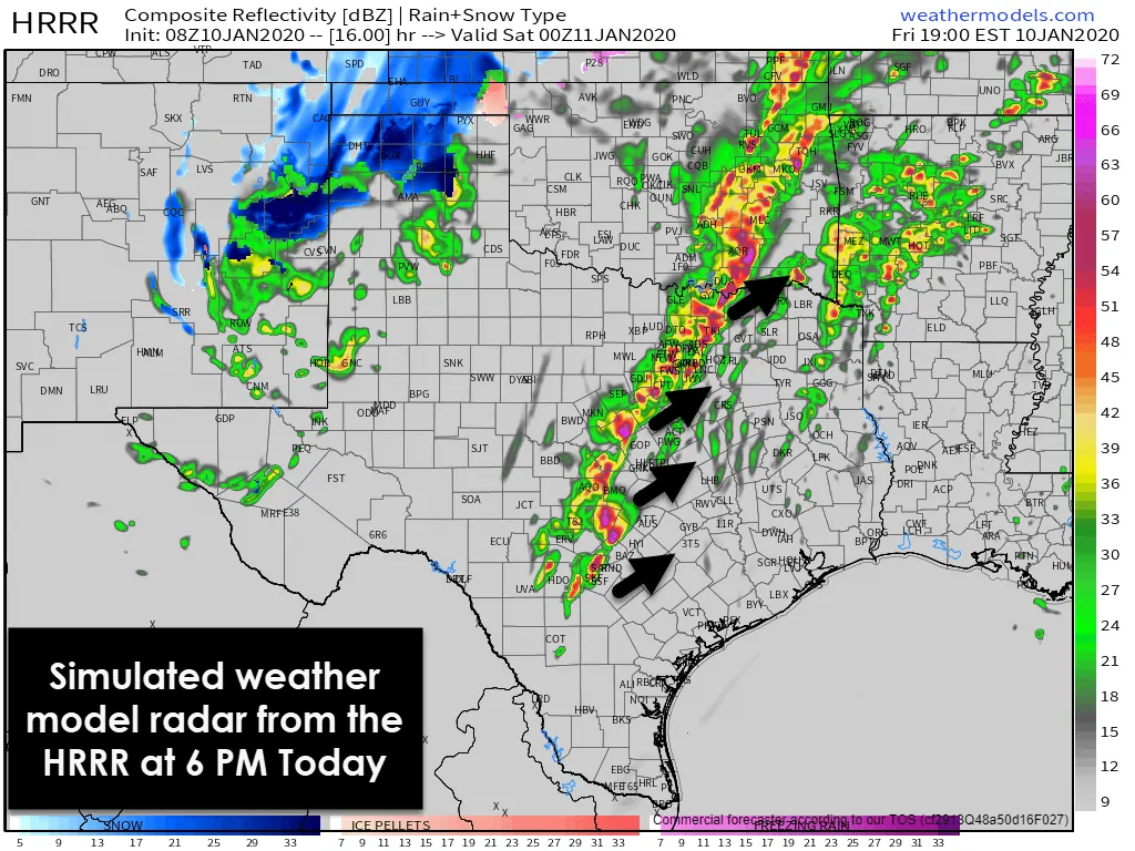
Simulated weather model radar from the HRRR at 6 PM today. Click the image for a larger version.
By 6 PM, we anticipate numerous thunderstorms underway near a cold front from Bonham to Dallas to Gatesville to Dripping Springs to San Antonio. The strongest of these storms will be severe, with damaging straight-line winds over 70 MPH and perhaps tornadic. If we have a linear storm mode by this point, the threat for a few tornadoes, while existant, will be secondary to damaging straight-line winds. Large hail will remain a possibility, and any storm that fires could produce very large hail for the first hour or two of its lifecycle. The squall line will be moving east while individual storms move northeast.
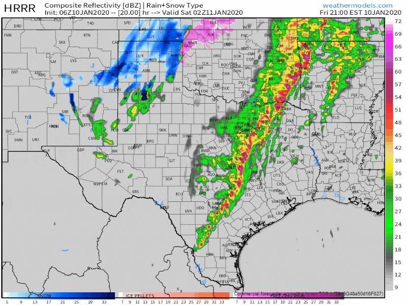
A simulated weather model radar from the HRRR beginning at 8 PM today through 8 AM Saturday. Click on the image for a larger version.
As we continue into the evening, a line of strong to severe thunderstorms will move eastward across Northeast Texas, East Texas, the Brazos Valley, and into Southeast Texas. Timing may shift an hour or two in either direction. Still, it looks like storms will be moving into Tyler and College Station around 9 PM, Houston and Lufkin around 11 PM, and Beaumont around 1 AM. The most intense portions of the squall line, which will likely exhibit ‘bowing’ structures, could produce hurricane-force winds over 75 MPH.
That damaging wind threat is expected to be highest in East Texas, where I have serious concerns about downed trees. We’ll also have to watch Southeast Texas for a severe weather risk tonight. Still, the higher coverage/intensity storms may remain just north of the Houston metro. We’ll yet have to watch for spin-up tornadoes within those stronger sections of the squall line. A quick one to two inches of rain will fall with the squall line’s passage.
Snow chances tonight through Saturday morning
Thunderstorms and the threat for severe weather will move east out of Texas by 2 AM. That’s when our focus will shift back west to snow. We may see some parts of the Texas Panhandle get a quick one to two inches of snow this evening, although it’ll be hit and miss. A thin snow band may move eastward across parts of the Big Country and Northwest Texas during the pre-dawn hours Saturday.
Warm soil temperatures will work against accumulations, but we may see some folks get a dusting to one-half inch of snow. Snow prospects will significantly depend on the track of a surface low pressure, and just like thunderstorms today, small scale features (mesoscale) can make or break a forecast.
Outside of the aforementioned light snow chances, much of Saturday should feature falling temperatures and drying conditions across Texas. A significant severe weather episode will continue to move east into the Southeastern United States. At the same time, a significant winter storm unfolds from Central Oklahoma northeast up to Chicago.


0 Comments