
We’re now within the three-day mark for the well-discussed severe weather potential on Friday. Weather model data has continued to indicate a relatively impressive severe weather set up across the eastern third of Texas. There continue to be several uncertainties, and we’re not locked in for a big-time outbreak by any stretch of the imagination. Three days out means we can still have changes that knock ingredients out of alignment.
A severe weather threat may begin late Friday afternoon near Interstate 35 in North Texas. Severe storms would then expand south and move east into the Coastal Plains, Southeast Texas, the Brazos Valley, East Texas, and Northeast Texas Friday evening and Friday night. Severe storms will not impact everyone. I do think the chance of you getting some rain is high, but that doesn’t mean everyone is going to be getting wind damage, hail, or a tornado on their street. I’m just a bald guy in my late twenties trying to provide a weather forecast while taking into account Mother Nature’s tendency to try and make me look more foolish than I already do regularly.
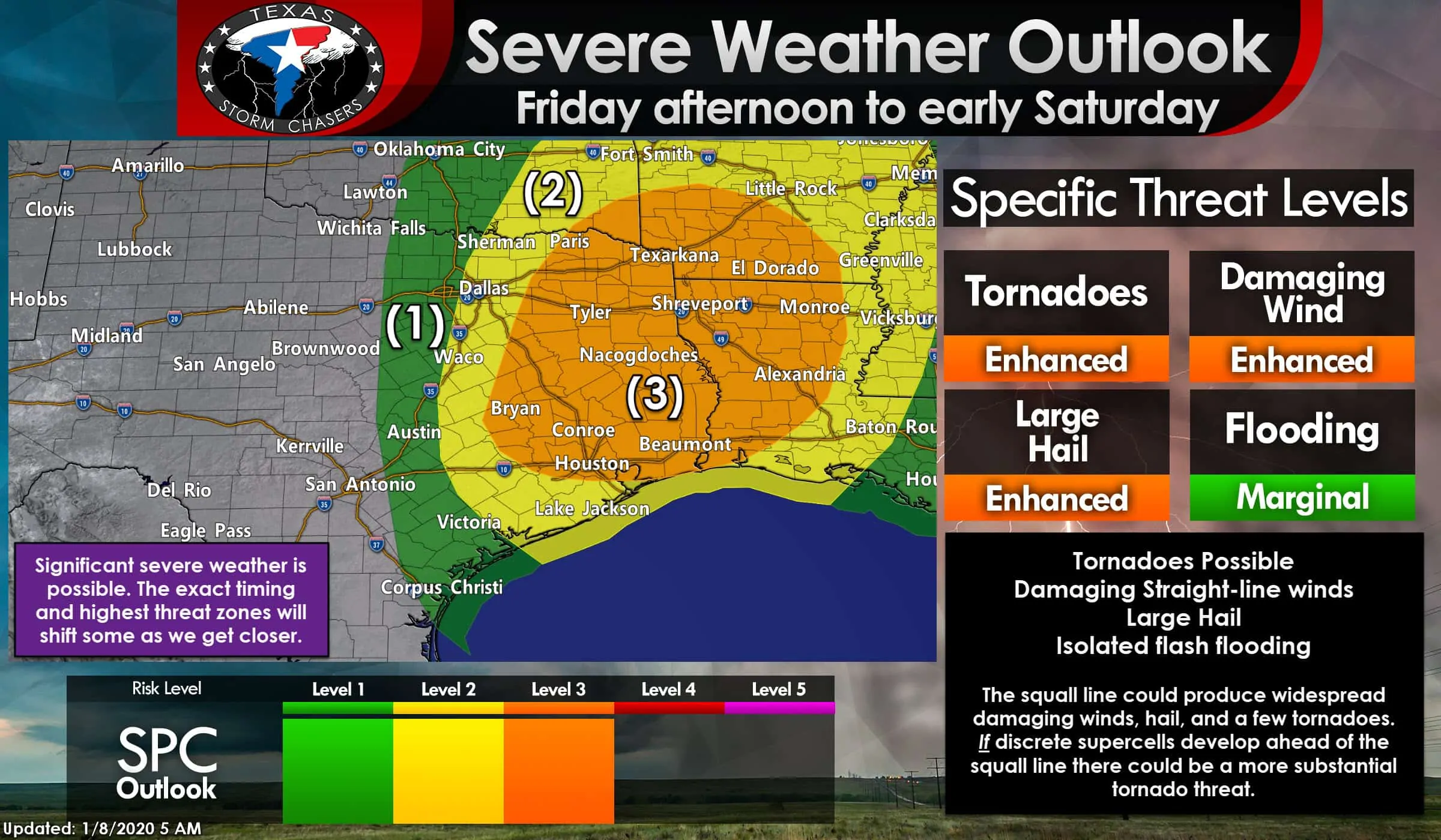
We’re now within the range where the Storm Prediction Center starts to get a little more detailed with their severe weather outlooks. One change is the expansion of level three (enhanced) risk probabilities into Southeast Texas. A second alteration includes a minor extension westward with the severe weather probabilities. Truthfully, the western edge of the risks is going to be where storms first fire up Friday afternoon. They’ll get loud in a hurry once a squall line fires up just ahead of a cold front/dry line. Of-course, that ‘zone’ happens to be right on several large population centers. Anyway, the western risk lines will probably be shuffled around a bit over the coming days. Pay attention if you’re in or near any risk zone.
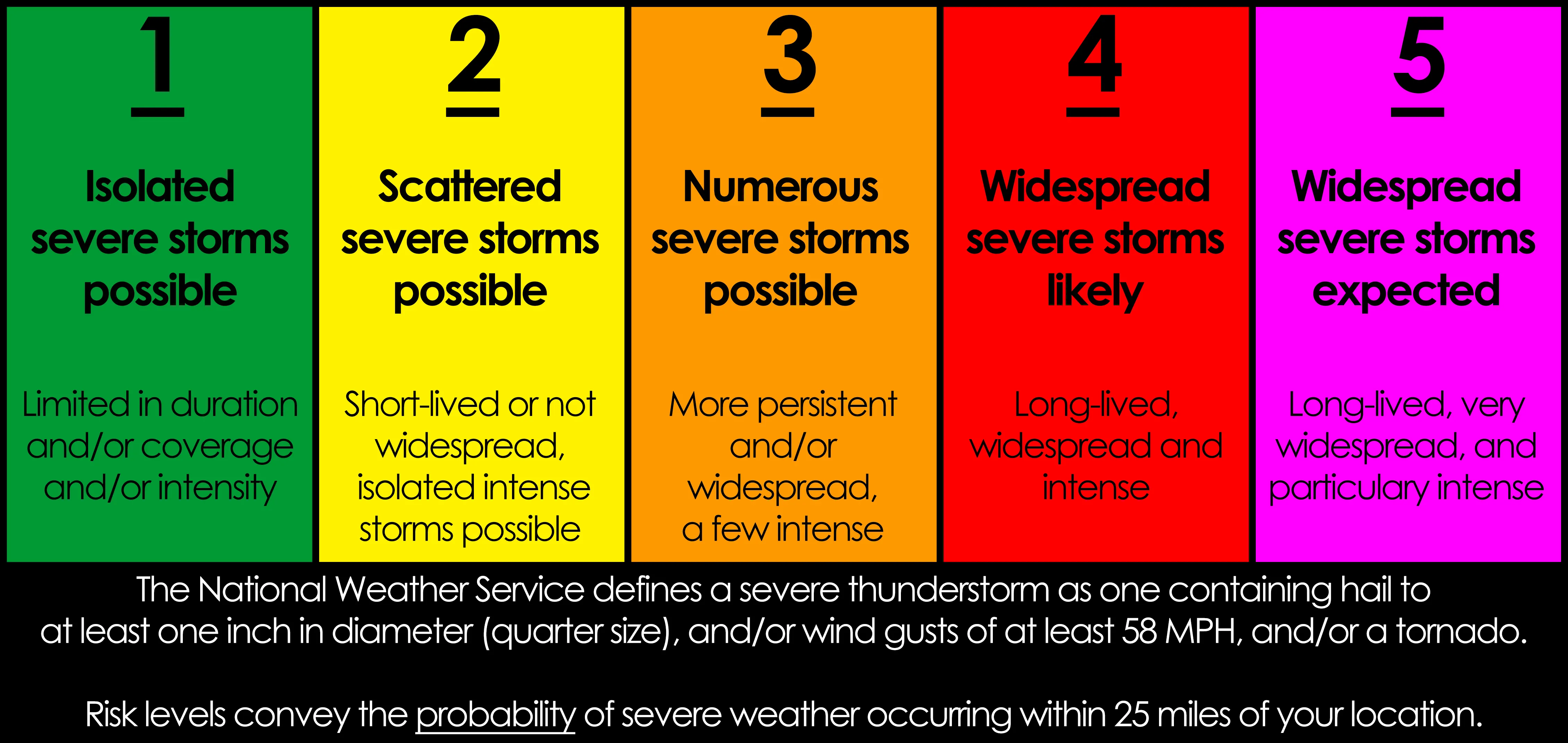
A level three out of five risk of severe weather includes all of Northeast Texas, East Texas, the Golden Triangle, Southeast Texas, and eastern sections of the Brazos Valley. Paris, Fairfield, Bryan/College Station, Houston, Conroe, Beaumont, Nacogdoches, Tyler, Texarkana, and Lufkin are a few cities included in the enhanced severe weather threat. Those within the level 3 risk have a 30% chance of severe weather within 25 miles of their location (a roughly 1 in 3 chance)
A standard level two out of five risk runs west to Interstate 35 from just east of Gainesville to D/FW Airport to Temple south to Bastrop to Yoakum to just east of Port Lavaca. Those within the level 2 risk have a 15% chance of severe weather within 25 miles of their location.
The level one out of five risk runs from just west of Oklahoma City south to Bellevue to Mineral Wells to Stephenville to Lampasas to New Braunfels down to Mathis to Robstown. Those within the level 1 risk have a 5% chance of severe weather within 25 miles of their location.
I’m going to show two images from the European weather model. These images depict that model’s solution for what the radar might look like Friday evening. Please keep in mind that the European model is not one of our typical high-resolution weather models. Data is more coarse and is three days out means it will likely change somewhat. I’m merely showing the images to help provide a rough timeline for folks. Most of our readers will know that stuff will change over the next 72 hours, but that was my lengthy warning otherwise.
Timing and threat details on Friday
The European weather model is on the slower side compared to its American counterpart. The American weather model is about three to six hours faster with the squall line’s eastward progression. This model also fires storms up a bit farther west, which would have implications for D/FW, Waco, Austin, and the San Antonio metros. I’m not convinced we’ll have to deal with severe storms as far west as this model solution indicates, but that’s something we’ll get a better handle on over the next 36 to 48 hours. Regardless, once the squall line fires up, it’ll feature strong to severe thunderstorms that’ll progress to Alabama on Saturday. The severe weather threat will end in Texas a few hours after midnight Saturday as the squall line moves east.
Low-level wind shear is expected to increase substantially east of Interstate 45 in North Texas and east of Highway 77 in the Brazos Valley and Southeast Texas. Tornadoes embedded within more substantial areas of significant straight-line winds are possible, if not likely. While not shown on the coarse model images, there may be some embedded supercelluar storm structures or attempts at discrete supercell development ahead of the squall line. Any supercelluar storms could pose a substantial tornado risk, given the forecast instability and kinematics (wind shear). Instability values, especially across the southern half of the risk zone, will be pretty impressive for January. Those higher instability values mean we may even have to deal with a large hail threat, something not as common during the ‘cool season.’
Tornado potential
In terms of tornado potential, we are concerned that we could have some spinups within the squall line, as previously discussed. There are also some model hints that a few discrete thunderstorms may develop ahead of the squall line Friday evening in the Arklatex, East Texas and Southeast Texas. Just like October 20th, if we have discrete supercells develop ahead of the squall line – those storms would have a much higher tornado risk. That higher tornado risk is conditional on discrete storms firing ahead of the squall line and maintaining themselves. It’s far from a guarantee and something we’ll be able to get a better grasp on as we get closer to Friday and into the range of convective-allowing high-resolution weather models. Small-scale factors (known as mesoscale) will also play a critical role in determining the specific severe weather threats. It takes many ingredients coming together just right to support a tornado threat or even a significant severe weather event. Just like a cake, you mess one little thing up, and it just doesn’t happen right.
Remain Weather Aware Friday!
Our clear message continues to be folks in the eastern third of Texas need to be weather aware Friday afternoon and Friday night. Being weather aware means checking back for forecast updates tomorrow and Friday morning. Have several ways to receive weather warnings come Friday afternoon into Friday night. That can include having wireless emergency alerts (WEA) enabled on your cell phone, so you get those tornado warning notifications. Local television stations and even your community’s emergency management probably have free weather warning apps too. Know what you’ll do and where you’ll go if a tornado warning is issued for your location. Those living in manufactured housing or mobile homes need to pay extra attention since you’ll have to move to a safer spot. Considering we may be dealing with widespread damaging straight-line winds, I also want to emphasis my worry of falling trees on structures. Pay attention to those severe thunderstorm warnings too! We’ve got a page full of safety information for different types of structures here.
Isolated flash flooding possible
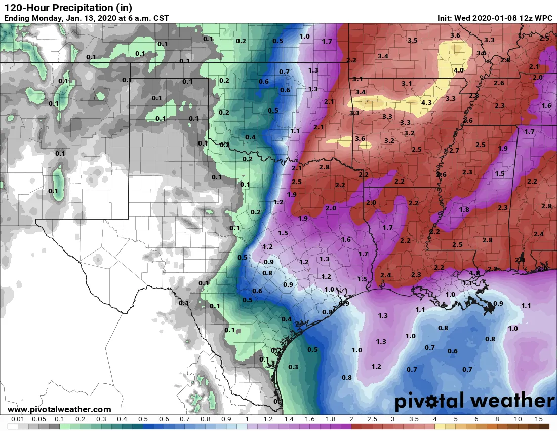
Potential rain totals with the Friday event
Recent dry weather and the relatively progressive nature of Friday’s storms should keep the threat for flash flooding isolated. However, some spots may deal with street flooding and minor flooding. Overall, we do not anticipate widespread flooding with Friday’s system.
A little snow as the system departs Saturday?
I’m not going to talk about it much since it doesn’t look like a story maker. We can’t rule out a few snow flurries Saturday morning in Northwest Texas and Texoma. As of now, it doesn’t look like anything worth writing home about.


0 Comments