
Hi there! We have a large number of regular readers who have joined us previously in the days leading up to a potential severe weather event. Others may be new and have just found us off social media or from a friend. Regardless, welcome to our humble abode. Let me begin by saying that I’m not here to try and scare you or to make a weather forecast four days out sound doomsday like. I’m merely going to tell you what is currently in the forecast. I’ll also explain what parts of the forecast remain more questionable and what all of that means. Thank you for taking the time out of your day to check us out.
Let’s start off by checking the latest severe weather outlook for Friday. These are probability-based outlooks issued by veteran forecasters at the Storm Prediction Center. The outlook will have two primary shaded regions. Do not get tied up on exactly where those lines are drawn. At four days out, these are an extended range ‘heads up’ that severe weather is possible. If you’re in the yellow or orange zone, simply know you are in a severe weather risk beginning Friday afternoon lasting into Friday night.
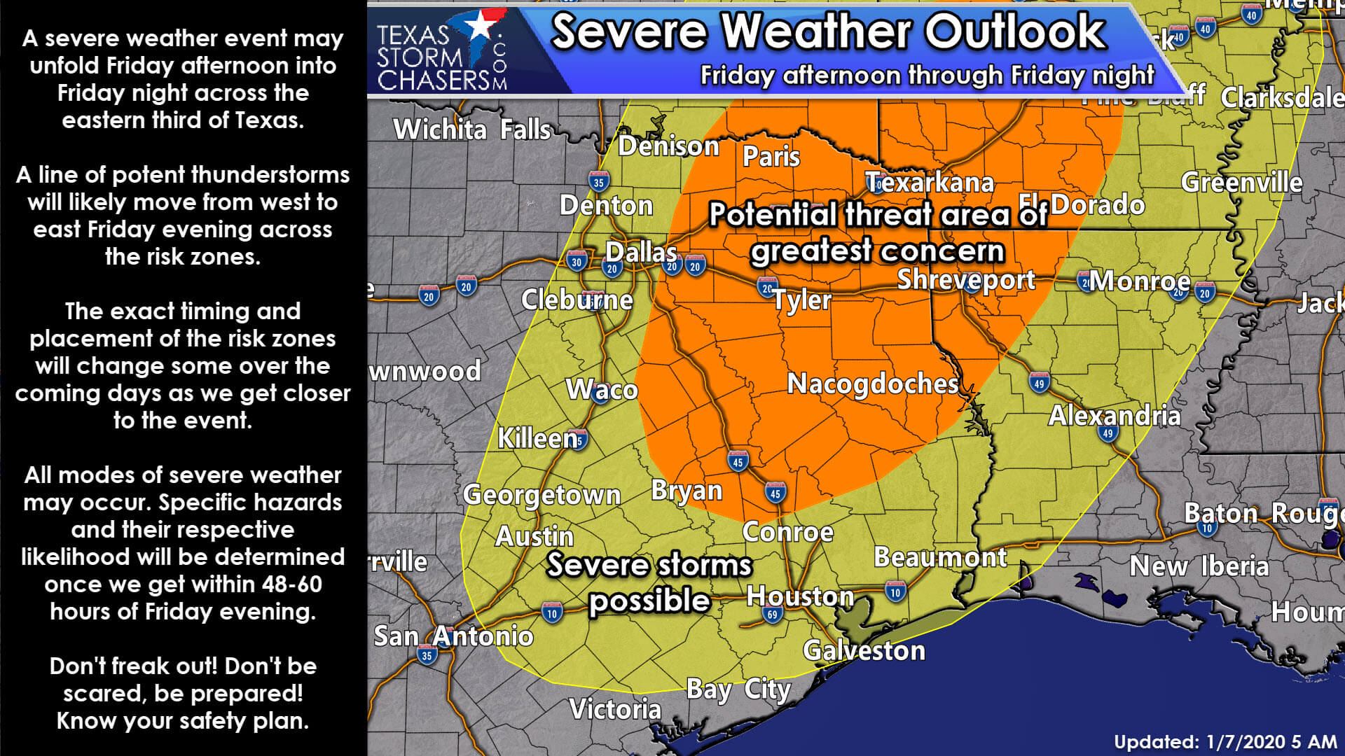
Remember when I mentioned these outlooks are based on probabilities? Those in or near the orange-shaded zone have a 30% chance of severe weather occurring within 25 miles of their location Friday/Friday Night. That’s a pretty significant designation being four days away. Surrounding that orange zone is a yellow-shaded zone. Those in that yellow-shaded zone have a 15% chance of severe weather occurring within 25 miles of their location at some point on Friday or Friday Night. Severe weather is defined as quarter size hail or larger, winds at or exceeding 58 MPH, or a tornado.
Please note that we’re not diving into specific threat levels at this time. We’ll be able to better grasp the particular threats (tornadoes, damaging winds, hail) once we get within 48 to 60 hours of Friday afternoon. I am comfortable saying that all modes of severe weather do appear possible. That’s not to say we’re going to have a tornado outbreak. Still, there does seem to be some ingredients that *may* come together to support a tornado threat. We simply are not in the range where we can pin down the specifics yet.
A robust upper-level storm system is going to move across Texas on Friday and Friday night. There remains a six to nine-hour time difference amongst various weather model data. A slower trend would result in the severe weather risk beginning a bit farther west (which the above outlook trends towards) in the late-afternoon hours Friday before moving east across the eastern third of Texas into Friday night. A faster pattern would have stronger thunderstorms try and get going by the mid-afternoon hours on Friday east of Interstate 35 in North Texas. Those storms would be impacting the Arklatex during dinner-time and moving east of Texas not long after midnight Saturday. Regardless, I am not comfortable narrowing down a time window at this range.
I am a bit more confident in my expectation of a line of severe storms moving across at least parts of the risk zones Friday evening into Friday night. I do think we’ll have a gnarly line of storms impacting Northeast Texas, the Arklatex, and East Texas at some point Friday evening or Friday night. Powerful winds in the low-levels and in the jetstream above won’t make it difficult to mix (or drag down) some of those stronger winds to the surface in thunderstorms.
Damaging straight-line winds are a fairly significant concern at this point. A tornado threat may also exist given projected strong low-level wind shear values. Tornadoes embedded within squall lines tend to be shorter-lived than in discrete storms but can still do quite a bit of damage in association with more significant swathes of damaging straight-line winds. I’ll be able to define a time-frame and specific threats better once we get closer to Friday.
As usual, we’ll have to watch for any discrete thunderstorms that try and form near or ahead of the squall line on Friday. We’re too far out to get a good grasp on the chance for discrete storms. The squall line itself is looking likely at this point, and we’ll just have to wait and see what high-resolution weather model data suggests when we get into that range.
Thunderstorms on Friday will also produce locally heavy rainfall. Recent dry weather will help mitigate some of the flooding risks. Localized flash flooding could still occur, especially in Northeast Texas and in the Arklatex Friday night into Saturday morning.
The threat for severe thunderstorms will end by Saturday morning (at the latest) here in Texas. Much colder weather will filter in on the back-side of the departing storm system. In fact, we may even see a few snow flurries in Texoma on Saturday.
You can get your local weather forecast directly from the National Weather Service. Likewise, we’ve also got a free interactive weather radar right here on our website or in our mobile app that will come in handy come Friday.

Build your tornado safety plan! Click on the image to learn more.
I do encourage those everywhere across Texas, regardless of if they’re in a severe weather risk on Friday or not, to make sure they have a severe weather safety plan. Making that safety plan during a tornado warning isn’t a good idea. Taking the time now while the weather is beautiful to pick out your safe spot, organize supplies, and practice it with your family is the way to go. California gets earthquakes – we get severe weather. It’s a part of living in this part of the country. Your safety plan will depend significantly on the type of structure you live in – and will impact just how ‘weather aware’ you need to be during severe weather. Visit our severe weather safety center to build your plan!


0 Comments