
Dense fog this morning across the eastern half of Texas should gradually lift by the late morning hours. Don’t expect too much sunshine today with mostly cloudy skies forecast for all of Texas. Spotty showers and isolated thunderstorms could occur this afternoon in North Texas and East Texas. I can’t rule out small hail with any isolated stronger storm, but severe weather is not expected at this time.
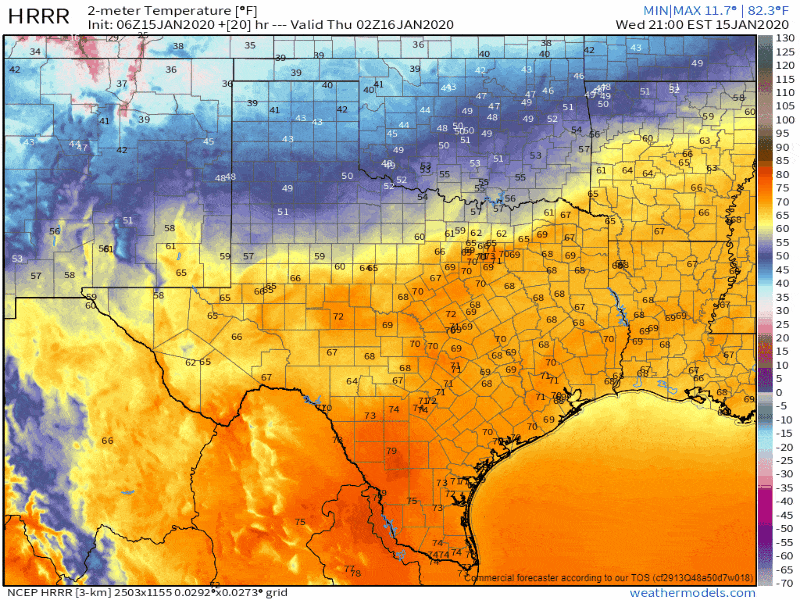
Surface temperatures tonight through 11 AM CT from the HRRR model. Times are on the top-right part of the graphic but are in ET. Click on the image for a larger version.
A cold front will push south late this afternoon into tonight. By midnight the cold front will likely be just south of Odessa to Brownwood to knocking on Tyler’s doorstep. Temperatures north of the front will gradually drop from the upper 60s down into the 50s, 40s, and 30s. The cold air accompanying the front is shallow and confined to within a few thousand feet of the surface. Warm-air advection, helping to moisten up the atmosphere, will continue above the shallow, colder airmass.
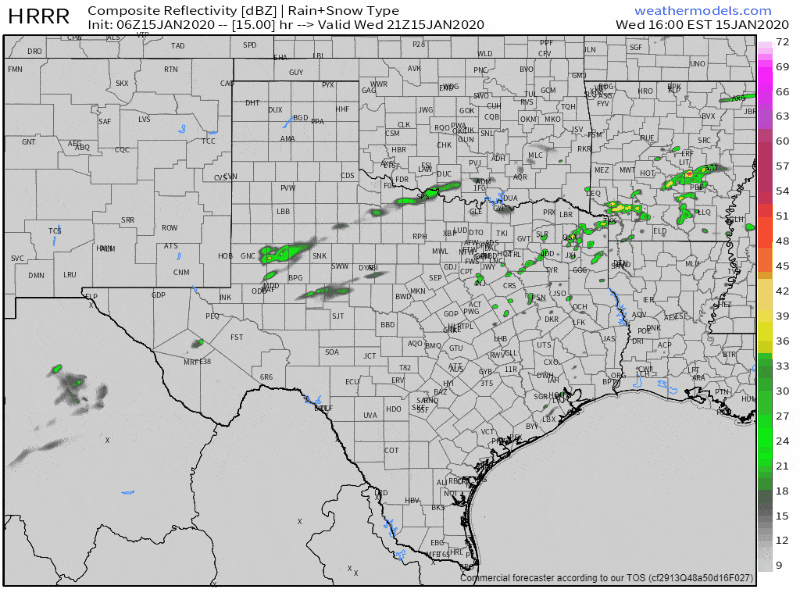
Simulated weather model radar from the 06Z HRRR for tonight into Thursday. Times are on the top-right part of the graphic, but are in EST. Click on the image for a larger version.
An increasing amount ascent in combination with the warm-air advection will result in increased potential for precipitation after midnight across the Big Country and North Texas. While temperatures at the surface will be cold, we’ll have a modestly unstable airmass in the mid-levels of the atmosphere. While not conducive for widespread severe weather, that modest instability may allow for some lounder thunderstorms capable of producing small hail. Individual storms will move to the northeast.
Scattered to numerous showers and thunderstorms are expected on Thursday north of the now-stationary front. The highest rain chances will be across the northwestern two-thirds of Texas, excluding the Borderland. Spotty showers are also possible in the warm-sector south of the cold front, but severe thunderstorms are not expected tomorrow. Small hail and obnoxious cloud to ground lightning are expected with stronger storms.
Widespread light to locally moderate rainfall will continue Thursday night into Friday morning near and west of Interstate 35. Yes, you read that right. I did say west of Interstate 35 for the highest rain chances Thursday night. Those rain chances, including the potential for a few thunderstorms, will progress eastward across the state on Friday.
Freezing rain and slick roads potential
Surface temperatures will be slowly warming all of Thursday, Thursday Night, and into Friday morning. How quickly surface temperatures warm above freezing on Thursday/Thursday Night will have significant implications on precipitation type and potential winter weather impacts in the Texas Panhandle and West Texas. These ‘slow warming’ scenarios are tricky because shallow cold air masses do not like to erode as quickly as weather models indicate. There is a big difference between sitting at 31 degrees with freezing rain versus 33 degrees and cold rain.
Freezing rain and travel impacts are possible Thursday evening into Friday morning across the Texas Panhandle southward into portions of West Texas. Surface temperatures will slowly warm through the event, so the rain/freezing rain (ice) line will gradually move north Thursday night and into Friday morning.
As said above, the timing on the northward progression of the freezing line is highly contingent on how the shallow cold airmass behaves. If temperatures warm more quickly, than we’ll see a shorter duration of freezing rain; if temperatures at the surface are slower to warm, we could see more significant impacts from freezing rain and ice tomorrow night in the eastern half of the Texas Panhandle.
Regardless, it only takes a trace of freezing rain to turn bridges, overpasses, and even roads into skating rinks. Two public servants in Lubbock were killed just last week while working a motor vehicle collision on an icy Interstate 27. Light freezing rain may not sound as sexy as light snow, but the impacts to roads are typically much more significant.
Precipitation will end from west to east Friday morning in the Texas Panhandle and West Texas. Temperatures should be mostly above freezing across both regions by 10 AM Friday, resulting in any rain still falling being ‘just rain.’
Friday onward into the weekend
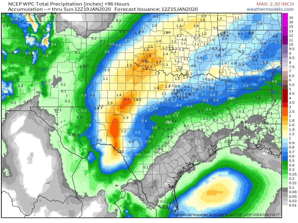
Forecast rain totals from the Weather Prediction Center (WPC) tonight through Saturday. Click the image for a larger version.
While Friday will bring warmer temperatures to Texas, that ‘warm-up’ will be brief. Another cold front will push south behind the departing late-week storm system. As the cold front moves south on Saturday, we’ll see temperatures get knocked back down to January averages across all of Texas. Average to slightly below-average temperatures will continue into next week as an active upper-level weather pattern continues. We’ll have to wait and see if we can squeeze out some winter weather, but considering our luck the last four winters, I wouldn’t hold my breath… but one can wish!


0 Comments