
Welcome to the third to last weekend of 2019. If that doesn’t make you wonder where the time has gone, I’ll say that Christmas is in eleven days. Don’t hate the messenger, but that also means that the spring storm chase season is only a few months out. We won’t be doing any storm chasing over the next couple of days, but we will have to watch for a few stronger thunderstorm chances — more on that below.
Fog is a problem again this morning across eastern portions of Texas. Dense fog will likely be an issue still tonight across the same areas. At least it’s not freezing fog, right? Those who experience fog are well above freezing and will likewise have a couple of warm days before our next strong cold front brings a return to December-like temperatures. Very warm to record high temperatures for December are expected on Sunday south of that cold front – at least until it arrives at your given location.
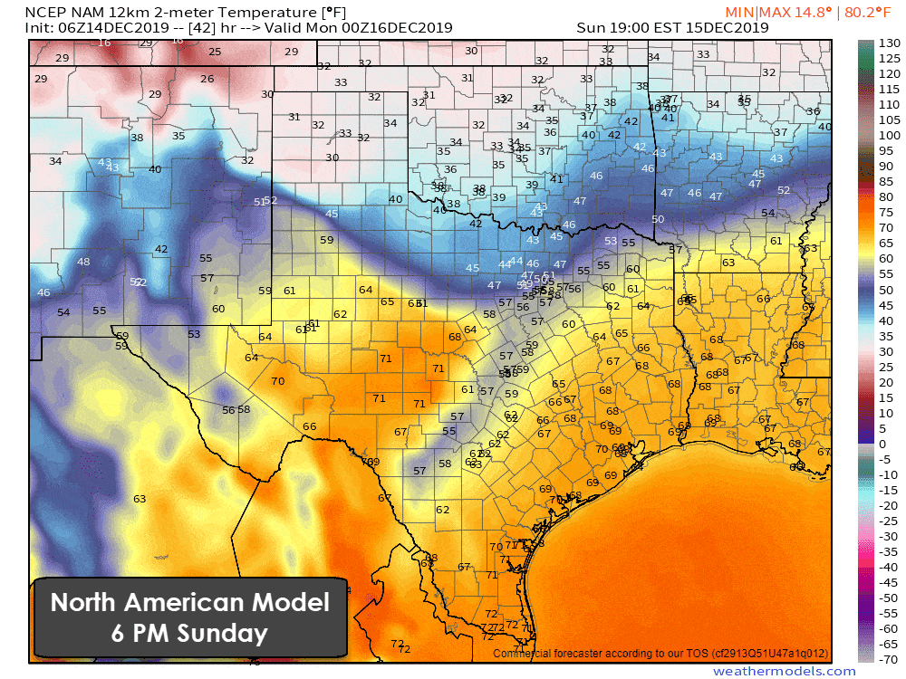
A strong cold front will progress south through Texas beginning Sunday in the north and late Monday in the far south. There will be a substantial temperature gradient as the front moves south. Temperatures south of the front will generally be in the 60s and 70s. Those north of the front will quickly fall into the 30s and 40s. Even colder temperatures are expected in the Texas Panhandle.
Light snow may result in a dusting to perhaps a one-half inch of snow accumulation north of Interstate 40 in the Panhandle tomorrow. More significant snow accumulations are expected just north of the Oklahoma and Texas Panhandles up in Kansas. As a snow-weenie myself, I am rather sad that we won’t be getting all that fun here in Texas. Oh well, there’s still a lot of winter to go.
Sunday and Monday’s cold front isn’t going to be a big rainmaker. Scattered showers are expected Sunday night and Monday morning across Eastern Texas and Southeastern Texas. I can’t rule out an isolated strong storm in Northeast Texas Monday morning, but I’m not overly impressed with those chances right now.
There is a level two risk of severe weather Monday morning into early Monday afternoon for far Southeast Texas, the Upper Texas Coast, into the Golden Triangle. Those areas could see a few severe storms as the cold front moves south.
Localized damaging wind gusts look to be possible with the stronger storms. A brief tornado and quarter size hail could also occur. Let’s get into Sunday and in range of the higher-resolution weather models to see exactly how this scenario may set up. It doesn’t look like a widespread or particularly significant threat as of now, but it only takes one mean storm coming down your street to make it a nasty storm.
Like the last few upper-level storm systems, this could end up being an event where far East Texas fires up the storms, but they don’t get overly rowdy until they’re in Lousiana and Mississippi. Quite typical for the winter severe weather season in the Deep South.
Rain chances will conclude
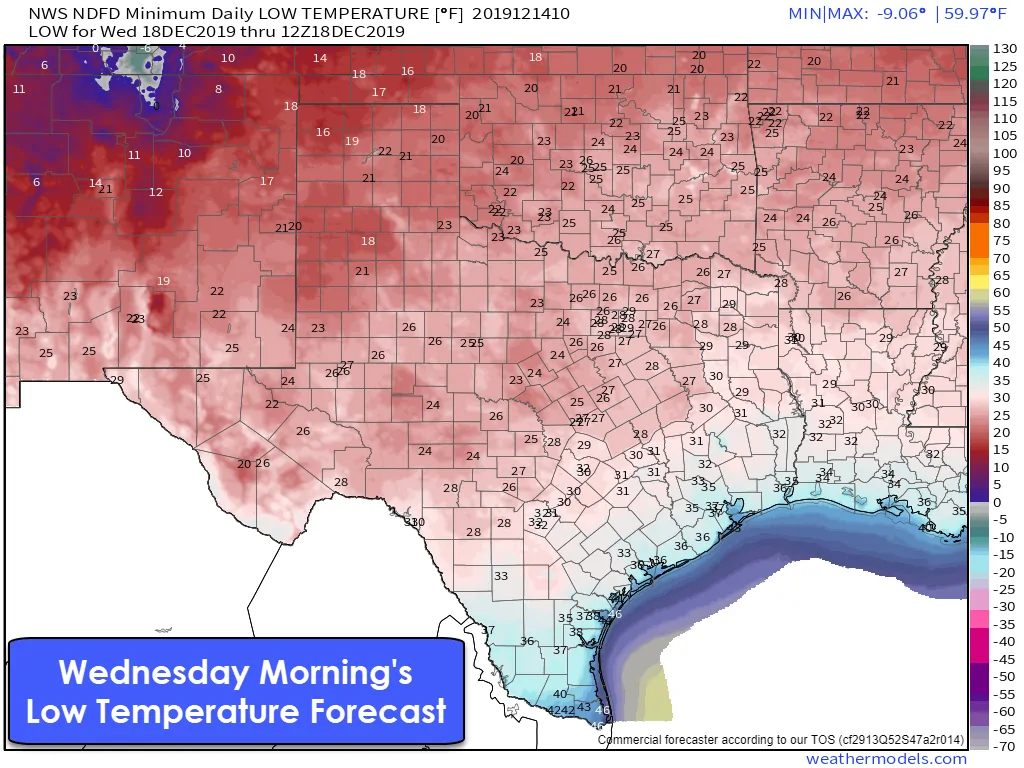
A colder and dry air mass will filter in behind our upcoming cold front. Clear skies and light winds should make Wednesday morning the coldest in the seven-day forecast. Freezing temperatures will probably make it into the San Antonio and northern Houston metros. The north three-quarters of Texas should expect sub-freezing temperatures by Wednesday morning. We’re not talking record cold with sub-zero wind chills, but it’ll still be chilly.
A brief warmup will occur during the day Wednesday before a reinforcing cold front arrives for Thursday and Friday. Warm weather fans shouldn’t be too sad, though. Next weekend leading into early Christmas week is looking warm.


0 Comments