
Good morning and welcome to a short work week as we approach Thanksgiving! Some of you may already be beginning your holiday vacation, and some will likely start their traveling on Wednesday. Regardless of your schedule this week, I hope it is a joyful and pleasant one. There are a few weather factors we’ll be watching for this week, but I’ll begin by saying no hazardous weather is anticipated on Thanksgiving Day. Yes, there will be rain and maybe a thunderstorm, but no severe weather is currently expected on Thursday. That may not be the case for Friday, however.
Tomorrow
A high wind event continues to look likely for much of the Texas Panhandle and West Texas on Tuesday. Wind gusts may exceed 60 MPH out of the west/southwest. That certainly isn’t comparable to the 75-80+ MPH wind event experienced this past spring, but it will be windy enough to cause issues. Blowing dust is expected – both locally and perhaps blowing in from eastern New Mexico. Lighter high profile vehicles will have difficulty with the higher winds.
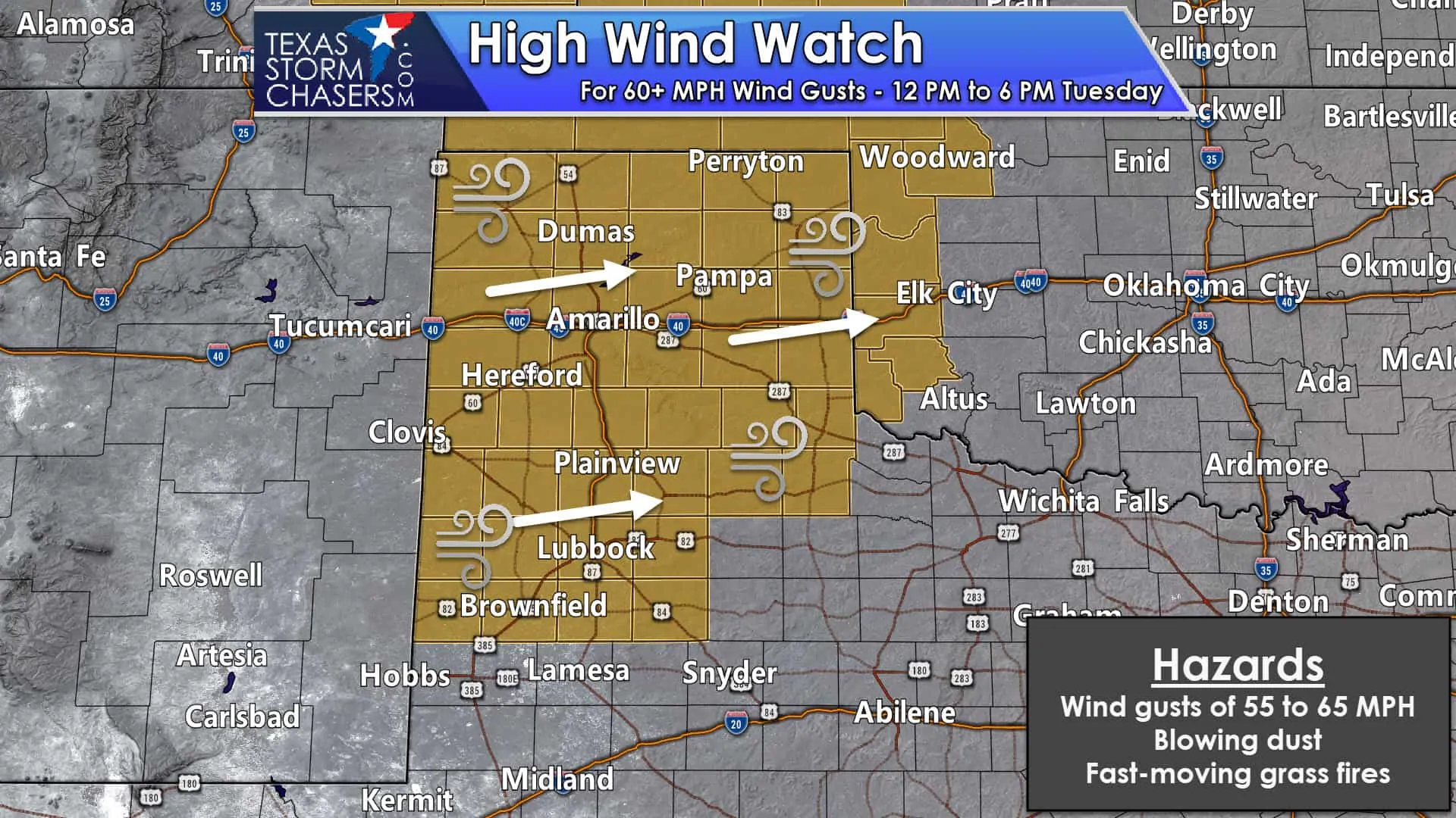
Humidity values will plummet into the teens, even though temperatures will remain relatively cool. Dormant grasses for the winter plus the ingredients mentioned above will support fast-moving grass fires. Recent wet weather will make wildland firefighting more difficult as soils will be soft, resulting in fire apparatus sinking and becoming stuck. Please be mindful of the higher wildfire danger tomorrow and know your evacuation plan should a wildfire develop to your west or southwest.
It’ll be windy outside of the high wind watch area tomorrow too. Winds across the western half of Texas and to the west of the dryline will gust up to 40-55 MPH. The threat of fast-moving grass fires will be very high on Tuesday across the western half of Texas.
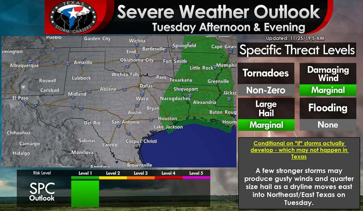
We also now have a level one risk of severe weather for portions of East Texas. Tomorrow’s marginal severe weather threat is highly conditional on there being thunderstorms in East Texas tomorrow. I’m not sold on thunderstorms, developing along an eastward-moving dryline before the dryline moves out of Texas. However, if storms to manage to fire up, they could be strong with some gusty winds and perhaps hail. I’ll have an update in this evening’s blog post regarding tomorrow’s storm chances (hopefully they’ll be gone!)
Winter weather potential Wednesday Night into Thursday morning
Overnight weather model data has trended warmer for Wednesday Night in the Texas Panhandle and West Texas. The warmer trend would reduce the probability of a significant winter storm. However, some winter precipitation potential remains evident, although it may end up being a freezing rain/rain mess versus a rain/snow event. Some slick roadways remain possible, especially across the northern Texas Panhandle. Those with travel plans Wednesday night and on Thursday in the Texas Panhandle and West Texas should stay in touch with the latest weather forecast. You can get a hyperlocal weather forecast on the National Weather Service’s website here.
Thursday
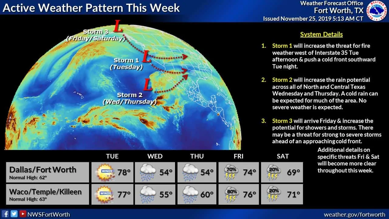
Not much has changed for Thanksgiving Day compared to my post last night. While rain is in the forecast for several regions of Texas at some point on Thursday or Thursday Night, no severe weather is expected. Your weather app or the National Weather Service’s link above will provide more detailed forecast information for your specific area of interest for Thursday. I’ll round back to the Thanksgiving forecast in my blog post tonight.
Friday
Weather model data has become somewhat agreeable regarding the overall weather pattern evolution for our late week system. Being five days out means the forecast specifics will change between now and Friday, but at least we can start to put together a more detailed forecast slowly. It may not be one you want, but alas I don’t control the weather, I talk about it and occasionally chase it while making obnoxious goat noises.
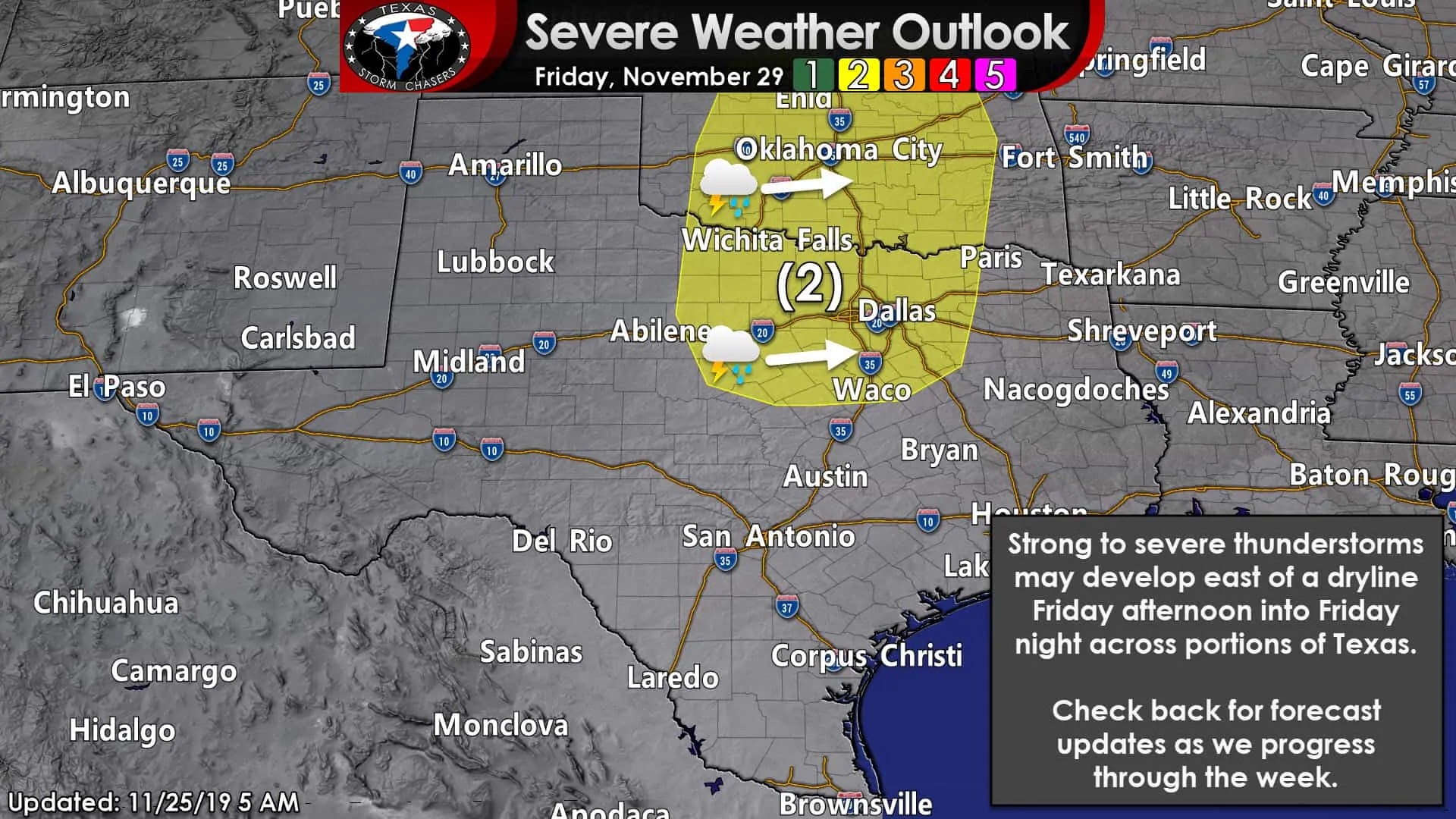
The Storm Prediction Center has introduced a risk of severe thunderstorms on Friday and Friday Night. That is noteworthy since we are still five days away, but it is not an indicator of a higher-end severe weather threat – at least, not at this particular stage. A risk being issued five days out is a good indicator that one should check back for the latest forecast later this week. Again, this will be the day after Thanksgiving. A level two risk of severe weather includes much of North Texas, Texoma, northward into a good chunk of Oklahoma right up Interstate 35. Don’t pay attention to exactly where the lines are drawn. They’ll change over the next five days – both in location and in the various risk levels.
Remember, we’re talking about a timeframe still well outside of higher resolution weather models. I cannot tell you if we’ll be dealing with a squall line, discrete storms, or a mix of both. I also cannot tell you just how all the ingredients mentioned above will come together – if they even come together in the first place.
There’s a rather precise recipe for various severities of severe thunderstorms. It only takes one ingredient out of place to reduce the potential event’s threshold significantly. Yes, severe thunderstorms are possible Friday afternoon into Friday night. Are severe storms guaranteed? No, but we’ll be keeping an eye out. Go about your week and enjoy it, but remember to check back for the latest forecast Thanksgiving evening. Fall is the secondary severe weather season for North Texas and East Texas.


0 Comments