
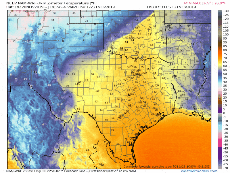
Good Wednesday evening, and congratulations on making it half-way through the work week! Even if you work a ‘gig’ job or have an a-typical ‘9-5’ job, one can appreciate the lack of a rush hour on the weekends. The weather across Texas this evening is gloomy with that strong southerly wind continuing overnight and into the day Thursday. The gloom is thanks to moisture flowing in from the Gulf of Mexico. Tonight will be pretty warm across Texas for November standards, too, thanks to those higher moisture values. Worry not though fall fans, our next cold front will make its way south through all of Texas by Friday night.
As expected, the widespread cloud cover kept instability values limited today across western portions of Texas. While we did have one stronger storm in Northwest Texas this afternoon, that activity has moved northeast into Oklahoma. I do not anticipate any severe thunderstorm threat for the remainder of this evening or during the overnight hours. Showers and an isolated thunderstorm may continue across the western half of Texas into Thursday morning.
Outside of any measurable precipitation, we anticipate overcast skies and some fog tonight across Texas. It’ll be one of those nights where we have some ‘spit’ coming out of the low-level overcast. Nothing hazardous, but not exactly a picture-perfect night either.
Crashy the cold front!
Model-projected timing on the cold front on Thursday and Friday.
We’ll have a cold front sitting near the Red River for much of Thursday. It will not move much during the daylight hours. It will be a focal point for new showers and isolated thunderstorms throughout the day. The front will start moving south late Thursday Night and on Friday as our next upper-level storm system arrives. Temperatures south of the front will be warm and humid for November standards. Once the front passes, your location temperatures will fall into the 50s and 40s. It isn’t an arctic cold front, but still, one that’ll knock us back down into the ‘cool’ territory. All locations in Texas should be behind the cold front by late Thursday night.
Accumulating snow tomorrow night in the Texas Panhandle
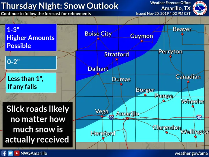
Accumulating snow is anticipated Thursday evening in the Texas Panhandle. We haven’t made any significant adjustments to the forecast since our update yesterday. The most substantial accumulations continue to be projected across the northwestern Texas Panhandle and in the Oklahoma Panhandle.
Folks like Dalhart, Stratford, Boise City, and Guymon could receive one to three inches of snow. Higher amounts cannot be ruled out. A dusting to two inches of snow accumulation is currently forecast north of a Vega to Borger(ish) to Canadian line.
Rain may mix with or briefly change over to snow north of a Muleshoe to Wellington line. Little accumulation is expected that far south at this time.
Roads may become slick wherever we see snow – even if accumulations are minor. Check back on Thursday for the latest accumulation forecast since Mother Nature always throws us a surprise or two with winter forecasting in the southern United States.
Isolated stronger storms possible on Thursday… maybe
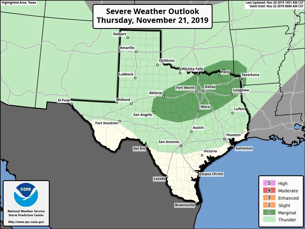
A level one risk of severe weather is in place Thursday afternoon across the Big Country, North Texas, a sliver of Central Texas, and Northeast Texas. San Angelo, Abilene, Fort Worth, Dallas, Paris, Waco, Texarkana, and Longview are a few of the larger cities in the risk. I’m not sold on the prospect of stronger thunderstorms tomorrow. Sure, there will be plenty of wind shear and a bit of instability, but the cold front’s faster southward movement may prevent more organized storms from firing up. High-resolution weather models aren’t enthused either. We’ll see if we can get stronger storms tomorrow, but it isn’t something I’m going to guarantee. If any stronger storms do develop, they could produce gusty winds and quarter size hail.
Expected rain totals through Friday night
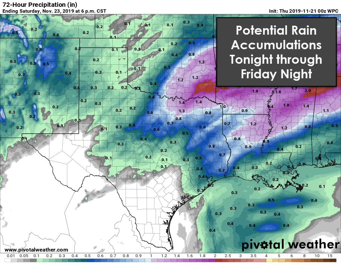
Regardless of stronger thunderstorm development, we do anticipate a line of showers and a few thunderstorms to fire up near and to the north of the cold front tomorrow night and on Friday. That activity may give some folks a quick half-inch of rain as the front moves south. Projected rain totals are not high enough to cause much of a flooding threat. Typical trouble spots like construction zones or low-lying areas may briefly have to deal with some street flooding under any more substantial activity. Cumulative rain totals, when including possible rains tonight and on Thursday, look to be highest in Texoma and Northeast Texas, where we may see some very minor flooding develop. Rain coverage will decrease as the front moves across the southern half of Texas and farther away from the stronger upper-level lift. Isolated to scattered showers are probable on Thursday and Friday south of the cold front where plenty of moisture has bottled up.
Weekend Weather in Texas
Are you looking for beautiful weather this weekend to start putting up Christmas decorations or spend time outdoors? You’re going to have it if you’re in Texas. This weekend’s weather will be excellent with temperatures not too hot, not too cold, but just right during the afternoon hours. No precipitation is expected.
Potential storm system next week
We are starting to look at the likelihood of a significant storm system in the Plains of the United States next week. Weather model data is all over the place – even more so than typical for an extended range dataset. Those various weather models indicate a scenario ranging from dry weather in Texas to one favoring a duo of a winter storm and a severe thunderstorm event. NO one can accurately tell you what will take place next Wednesday-Friday. We’re not too excited at this point, but we will be watching the land of weather model voodoo for an eventual outcome. The Midwest and the Northeastern United States are going to have a doozy of a storm system around Thanksgiving.


0 Comments