
The weather is going to take an active turn this week across the United States. I anticipate those traveling are going to have issues at various issues aviation hubs this week. For the weather at your destination, I encourage you to check the forecast at weather.gov.
In the absence of active weather over the last week, I’ve made a few website adjustments that our followers will hopefully find pleasant. Our website header (the menu bar at the top of this page) was changed to an appealing shade of blue. Most importantly is that yours truely spend way too much time optimizing, breaking, restoring, and re-optimizing this website’s loading processes. We hope that those improvements will lead to faster load times and also keep our site’s database from imploding when we send out an app notification.
Why should you care? Most shouldn’t, but I felt like sharing considering how much time I spent on it this past month. Anyway, let’s talk about the weather and get on to the real reason you’re reading this post!
Tuesday and Tuesday Night
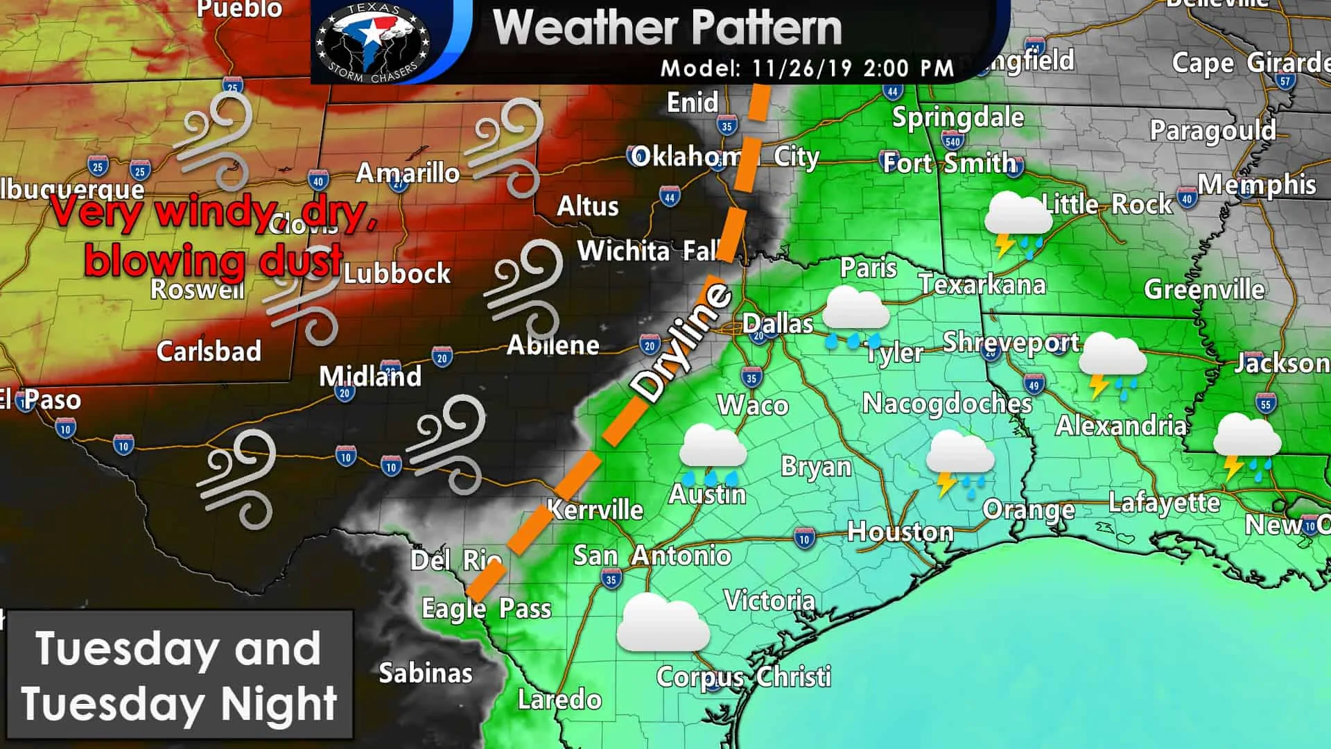
We’re going to get to say hello to our good friend the dryline on Tuesday! The dryline will probably set up about 40 to 75 miles west of Interstate 35W/Interstate 35 from Gainesville to Laredo by 2 PM on Tuesday. The eastern half of Texas will be in the ‘warm sector’ or east of the dryline. Cloudy skies, south to southerly winds, along with spotty showers are expected on Tuesday. The morning hours may start with fog for some folks.
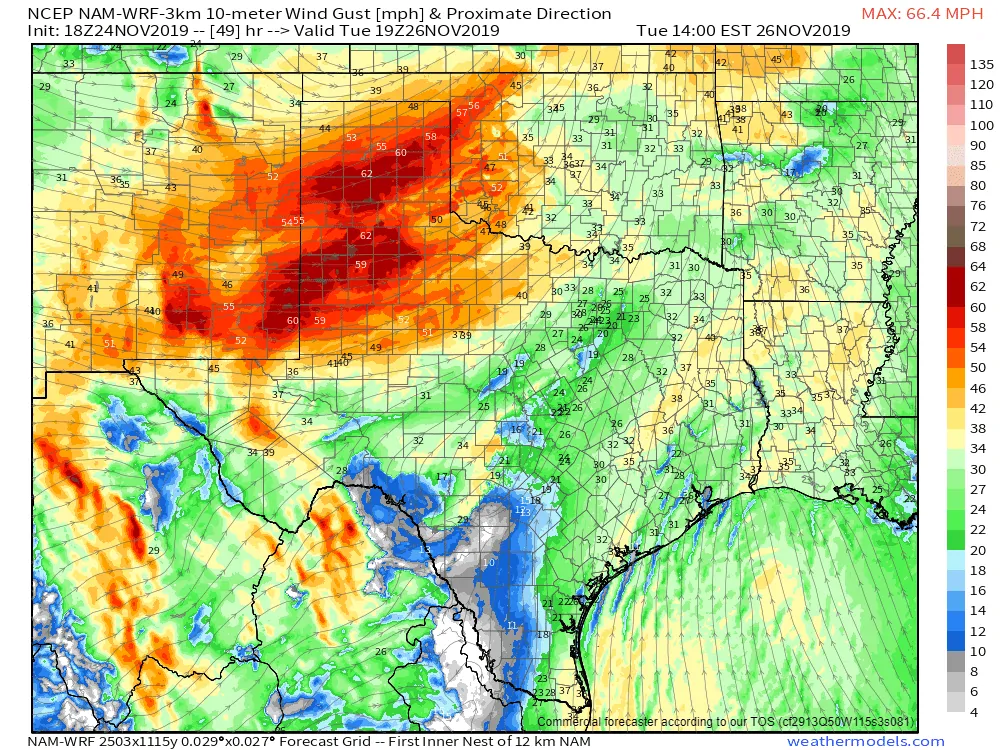
One weather model’s simulation of wind gusts around 1 PM on Tuesday. Note the 55+ MPH southwesterly winds being depicted across the Texas Panhandle and West Texas.
Strong to very strong southwesterly winds are expected to occur across the western half of Texas. Humidity values will also plummet into the teens. There will be an enhanced grass fire threat due to those strong winds and low humidity values. Having all the vegetation being dormant for the winter won’t help things – even though it has been wet over the last several weeks.
Any fire that develops in cured grass or unplowed fields will likely have a rapid rate of spread to the east/northeast. Don’t let your guard down on the flanks, though, as some erratic fire behavior could occur with those stronger winds.
A broken line of thunderstorms may develop just east of the dryline Tuesday evening in eastern North Texas. If that line develops, it will move east Tuesday evening across Northeast Texas and East Texas. Conditions aren’t overly favorable for stronger thunderstorms, but I can’t rule out a marginal severe weather risk with some gusty winds. We’ve entered the season of strong wind shear but limited instability values.
These fall and winter setups are known as ‘cool season’ setups. Typically we don’t have enough instability to produce longer-lived severe storms. That looks to be the case on Tuesday. We’ll watch it and have an update tomorrow. If the upper-level lift passes farther to the north, we may not have enough ‘oomph’ to get storms to fire south of the Red River. In that case – this paragraph is entirely and utterly moot.
Wednesday Night and Thursday Morning Winter Weather Threat
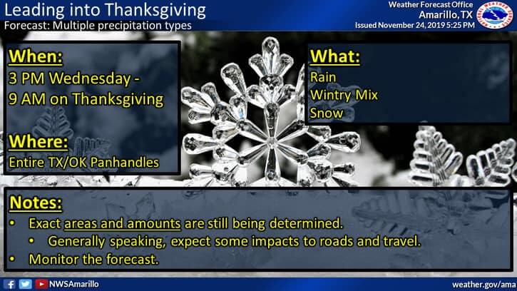
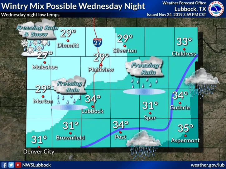
Winter weather is possible Wednesday Night into Thursday Morning across all of the Oklahoma and Texas Panhandles south into portions of West Texas. We’re too far away to determine precisely where the freezing line may set up or just what the exact precipitation types could be. Regardless of the precise kind of winter precipitation (sleet, freezing rain, snow, or a mix of all three) – travel impacts would be the most pressing concern given the time-frame.
Those traveling on Wednesday or Thursday in the Texas Panhandle or West Texas should keep apprised of the latest forecast. There is a threat for some significant winter weather accumulations on Thursday morning in the Texas Panhandle. Somebody *may* end up having quite a bit of snow on Thanksgiving up that way.
Wet and cool Thanksgiving
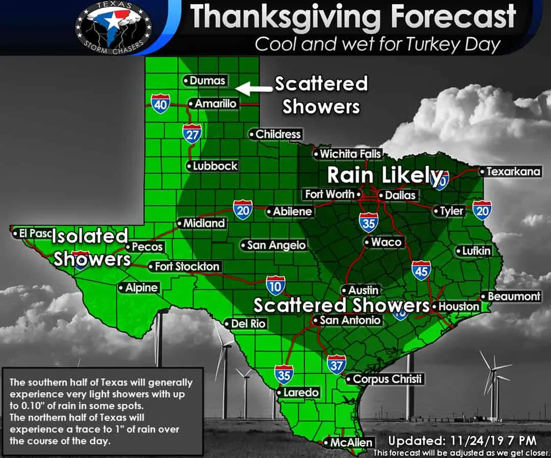
The northern half of Texas will be cool and wet on Thanksgiving. Scattered to numerous showers are likely throughout various points of the day. The highest rain totals look to be in Texoma and closest to the Red River. Those rain totals will be lighter the farther south you go. We note that the chances for precipitation in the Texas Panhandle may be in the form of winter weather – as discussed in the previous paragraph.
While the map for the southern half of Texas looks wet, that may end up being more of a drizzly/light shower thing versus an ‘I’m going to downpour on your Thanksgiving.’ I expect I’ll be able to finetune the map once we get a few days closer. Temperatures will be warmer across the southern half of Texas, with the 60s and 70s being prevalent. Severe thunderstorms are not expected on Thanksgiving… unless you have ordered our 2020 Weather Calendar.
Late Thursday Night through Saturday
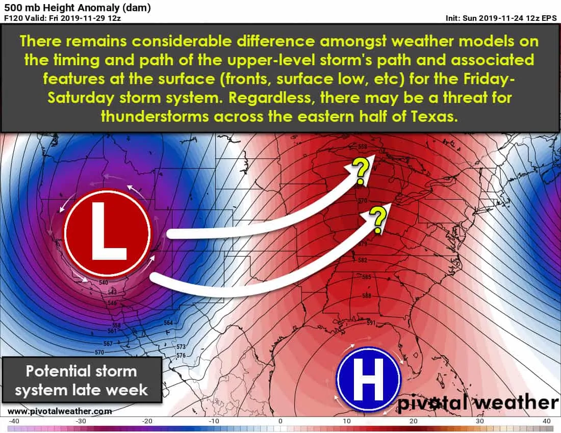
This is when things could get a little more interesting, but that is far from a guarantee. A powerful upper-level storm system will make its way into the Plains of the United States. This system has shown up in extended-range weather model data for over a week now. That’s about the only factor that has remained consistent, which isn’t unusual for the land of weather model voodoo.
The eventual track of the upper-level storm system, along with its surface counterparts, will play a significant role in what weather we have to deal with in Texas. While Wednesday and Thursday will be chilly, we should see a warmer and moister airmass spread northward Thursday Night and on Friday – ahead of this system. That means we will have to watch for the chance of thunderstorms, especially across the eastern third of Texas.
The late-week system does have the look of one that may support stronger thunderstorms. That’s what we call ‘synoptically evident’ – or a weather pattern that has historically produced more impactful weather in the past. Will we have to deal with severe storms in Texas on Friday/Saturday or will it all get going just to our east is still uncertain.
Regardless – please keep a tune of the weather forecast after Thanksgiving for Friday and Saturday. This system may also bring another high wind event to the western parts of Texas. We’re in the fall severe weather season across Eastern Texas.
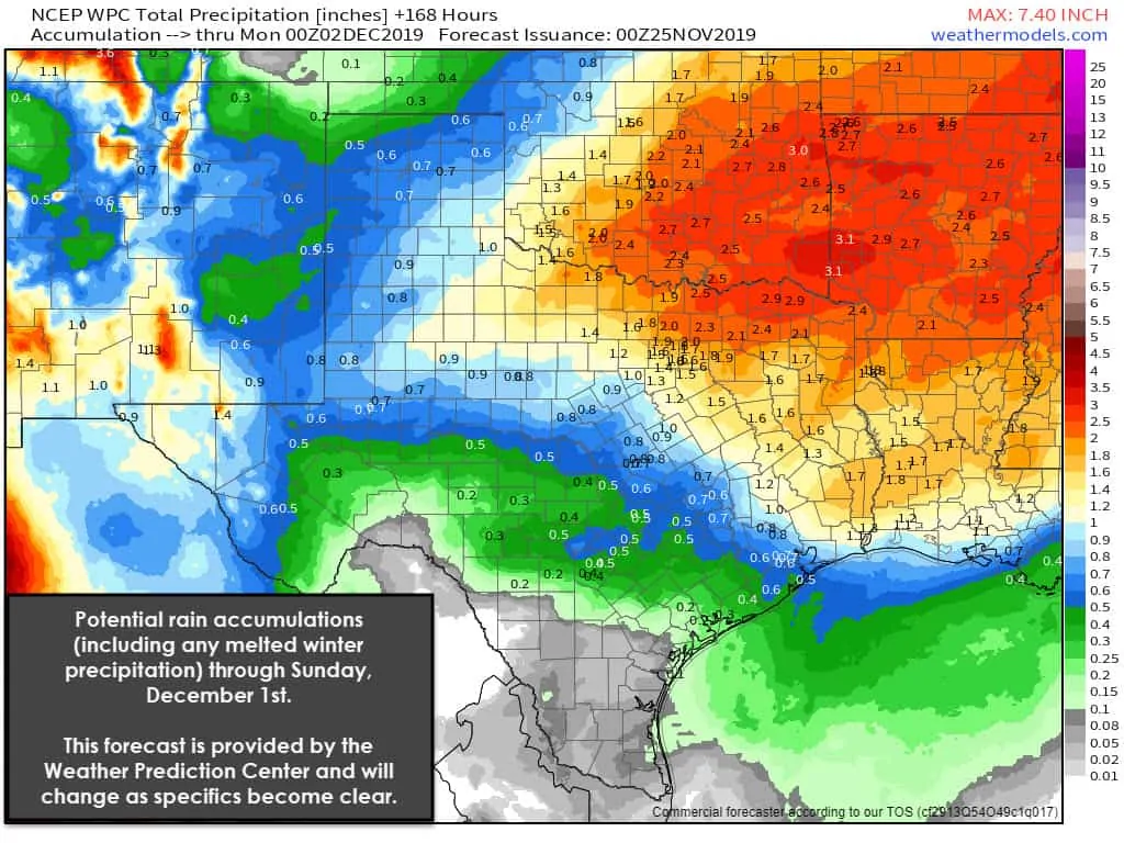
Here’s a quick look at potential rain totals across Texas through next weekend. Please don’t take the ‘exact’ rain totals for verbatim. That’s just automatically generated from the graphic. Use the graphic as a general guideline for the approximate range for rain totals. Remember this for the next week. That all won’t be falling within an hour or on the same day. We could see some river rises where over an inch of rainfall falls. Vegetation has gone dormant for the winter, so the ground isn’t able to absorb too much water – thus increasing runoff into drainage systems. These projected rain totals would not cause widespread or significant flooding.


0 Comments