
Late November in the United States can often be chaotic for weather folks. This year will be no different with three upper-level storm systems bringing a variety of weather to Texas through Saturday. The first system will be a wind maker, the second a rain and icemaker, with the third bringing the chance for more wind and an opportunity for thunderstorms. Thanksgiving Day itself could be damp, but no severe storms are expected on Thursday.
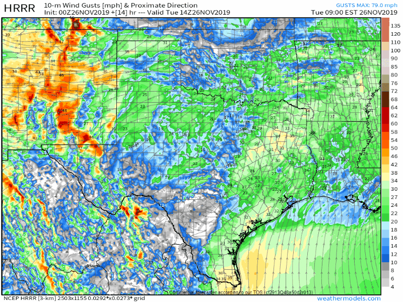
Projected wind gusts on Tuesday from the 0Z HRRR weather model. Take note of that wind shift with a southward moving cold front tomorrow night.
Tuesday and Tuesday Night will be windy across all of Texas. We’re anticipating very strong to even damaging winds at times tomorrow across the western half of Texas.
Those in the Texas Panhandle, West Texas, the Trans-Pecos, and Northwest Texas could see wind gusts of 55 to 70 MPH out of the west/southwest – becoming northwest tomorrow night. Blowing dust is a good bet.
The threat of grass fires will be very high to critical across the western half to western two-thirds of Texas. In addition to those strong winds, we’re also expecting relative humidity values to plummet. With fuels in dormancy, we could see some rapid rates of spread with any grass fires that get going.
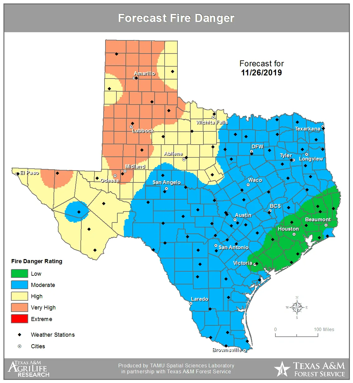
Forecast wildfire danger tomorrow (Tuesday, November 26)
There will be a notable danger to firefighters when a cold front arrives at their location. Winds will remain active but will become northwesterly versus west/southwesterly. Those wind shifts are problematic and can result in erratic fire behavior. Fire danger will continue to be high after sunset and well into the night.
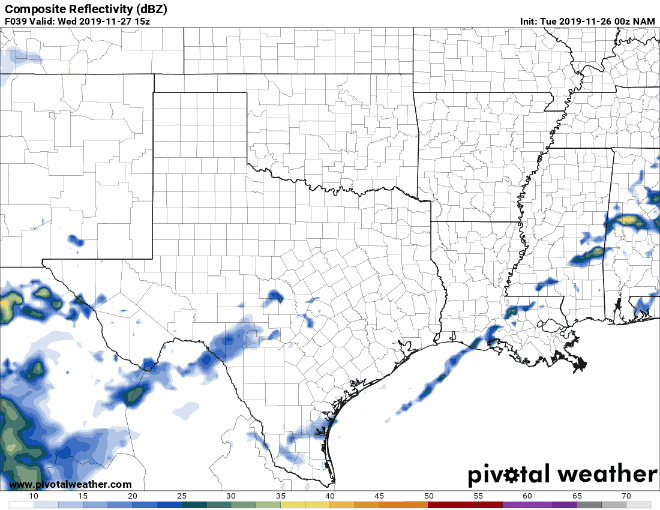
Simulated weather model radar from the North American Model on Wednesday into Thursday morning
Our second upper-level storm system will move across Texas on Wednesday and Thursday. This latter system will bring precipitation mainly to the northwestern half of Texas. We note that some of the rain shown in the simulation above may fall as winter precipitation in the Texas Panhandle and West Texas.
Some folks may pick up one-half to perhaps one inch of rainfall. The mid-week system is not a severe thunderstorm maker, nor is it one likely to produce flooding. Sure, driving in the rain isn’t fun, but at least we won’t have baseball size hail flying out at 80 MPH.
Some winter precipitation may occur Wednesday night into Thursday morning in the Texas Panhandle and West Texas. Weather model data has trended warmer over the past twenty-four hours. That warmer trend in model data has reduced the possibility of a significant winter storm. If we did have winter precipitation occur, it looks like a mix of freezing rain and rain. Surface temperatures look borderline right around freezing. Up by Dalhart and Boise City, it may get cold enough to support snow, sleet, and freezing rain for a time. Our primary concern with any winter precipitation would be for those traveling and potential slick spots on roads.
The two graphics above depict the chance of rain on Thanksgiving and Thanksgiving Night. While the maps do show a lot of green, I do want to emphasize that most of the rain would be light and not ongoing the entire time. We may see a lull Thanksgiving afternoon as our other upper-level storm system moves out. Additional precipitation may form Thursday night into Friday morning near the Red River.
Isolated thunderstorms are also possible Thursday night, although severe weather is not currently expected. Some small hail could occur. Thanksgiving may be damp, but we aren’t expecting severe storms or flooding. You can get a local forecast for your town of interest on the National Weather Service’s website at weather.gov.
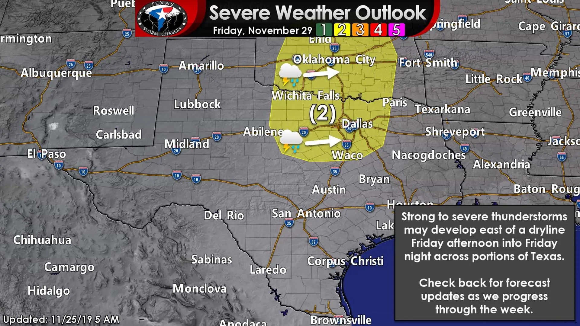
Our third upper-level storm system will make its way into the Plains of the United States on Friday and Saturday. A warm, moisture-rich, and relatively unstable airmass will make its way north into Kansas by Friday afternoon. A surface dryline will move east Friday afternoon into Friday night. A few severe thunderstorms may develop east of that dryline Friday evening across North Texas, Texoma, and Northeast Texas.
Today’s model data suggests the stronger upper-level lift may stay north of the Red River – keeping the higher threat of severe storms in Kansas and Oklahoma. Regardless, a few thunderstorms are possible Friday night in North Texas, Texoma, North Texas, and East Texas.
Some of those storms may be strong to severe, but we’re not talking about an ‘outbreak’ at this point.
We’re well into our fall severe weather season. These risks are normal – and not every risk materializes. Not every severe weather threat in the fall and winter automatically produces tornadoes out of the wazoo. We mention these severe weather risks days ahead of time to let folks know to check the forecast in a few days. I don’t tell them to scare anyone or to cause anxiety.
Trust me; you can find some other sources on the internet that make every upcoming severe weather threat sound like a super outbreak in the making. I never want to be one of those folks. Am I perfect? No, and don’t think I don’t look back after each event to ‘grade myself’ and improve for the next time.
Anyway, the chance of precipitation will move east of Texas on Saturday. The afternoon on Saturday may end up being windy as another cold front moves south – this one making it through much of Texas.


0 Comments