
Strong southerly flow and compressional heating ahead of a strong cold front will result in high temperatures approaching or exceeding prior records this afternoon. This does include the potential of triple-digit heat. I find the thought of triple-digit heat in October reprehensible and disgusting, but I’m a fall weather fan.
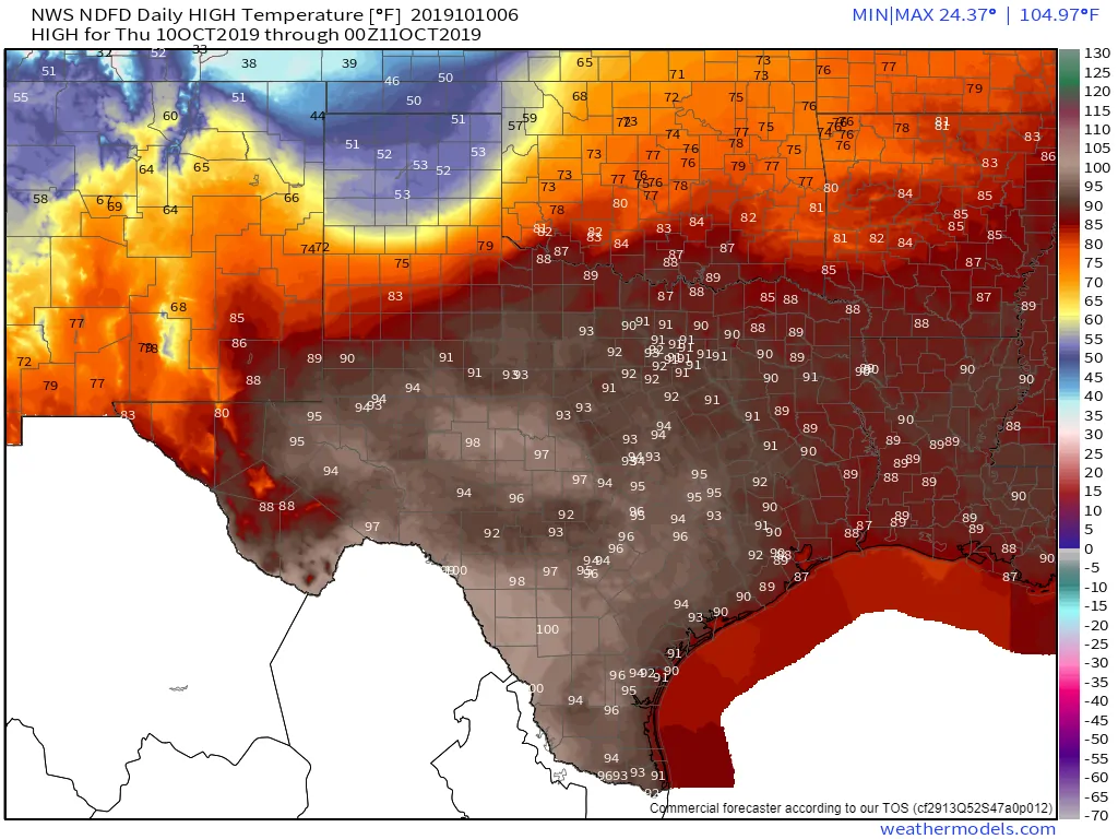
Today’s high-temperature forecast
Besides, near-record high temperatures south of the front will contrast nicely with a much colder air mass to the north. That contrast will make the ‘find the cold front’ game all that more fun later today and tonight. One will easily know when the front has arrived at their location. Temperatures will drop ten to twenty-five degrees in a matter of thirty minutes. Northerly winds will become gusty and rather obnoxious. Those gusty winds will be especially true in the northern half of Texas.
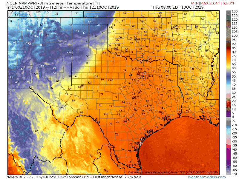
Shown above is a surface temperature plot from 10 AM this morning through Friday afternoon. I’ve utilized the North American Model (NAM). Each frame progresses forward three hours. This will hopefully provide a *rough* estimate on the cold front’s arrival time at any given location. Remember, this is only one model. As stated above this cold front will bring near-immediate changes once it arrives at a given location. Gusty north winds and quickly falling temperatures are expected. The high temperature for the day will be whatever the thermometer gets up to right before the front arrives tonight and on Friday.
Severe Thunderstorm Potential Tonight
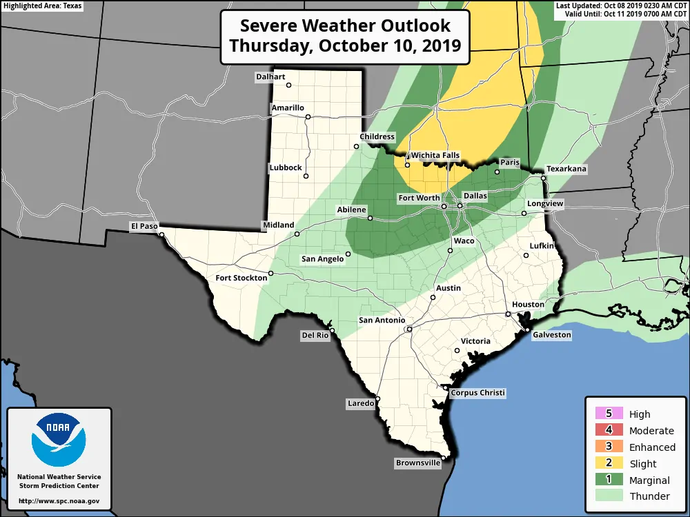
There is the possibility of strong to severe thunderstorms this evening and overnight across Texoma and North Texas. We have a level two risk of severe weather in place for Texoma and portions of North Texas. That’s the standard risk level from the Storm Prediction Center. A level one risk of severe weather surrounds it and includes the Big Country and Northeast Texas.
Localized damaging wind gusts over 60 MPH along with hail up to the size of golfballs will be the primary threats with the strongest storms this evening along the cold front’s leading edge. Most storms will not be that intense. I cannot rule out a brief tornado in the proximity of the Red River.
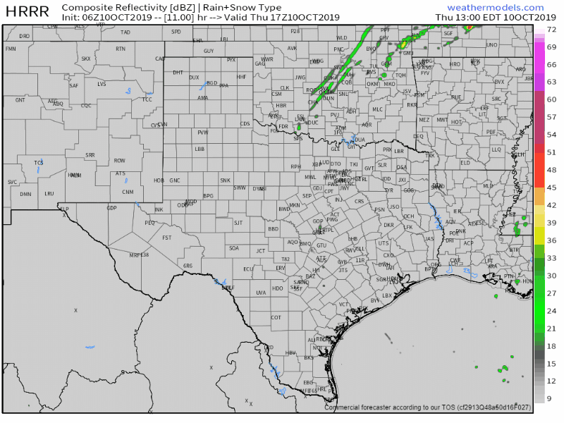
HRRR: Simulated weather model radar from noon Today to noon Friday. This is only one model’s data output simulating what the radar may look like today, tonight, and Friday morning.
Thunderstorms will increase in coverage overnight into Friday morning behind the cold front across the Big Country and North Texas. Storms behind the front will be elevated above the near-surface stable airmass. However, the airmass in the mid-levels of the atmosphere will still be unstable. Stronger storms may produce hail with some storms producing hail larger than the size of a quarter.
Coverage of showers and thunderstorms will be fairly high behind the cold front as it moves south tonight and on Friday. However, individual storms will be fast-moving. Thus we are not expecting excessive rainfall totals or a threat of flooding. Some lucky folks could get one to one and a half inches of rain locally. More widespread rain totals will tend to remain limited to a few tenths of an inch. Not everyone will get rain.
From record high temperatures to record ‘minimum’ high temperatures (hot to cold)
I’ll let readers examine the temperature forecast graphics above for day-to-day details on the temperature trends. I’ve included a few key points that I find interesting.
- A freeze is expected across all of the Texas Panhandle south toward Lubbock tonight into Friday morning. Wind chill values will range from five above zero to the teens. It will feel every bit a winter’s morning.
- High temperatures on Friday will struggle to get to 60 degrees across the northern/northwestern half of Texas. Winds will be gusty out of the north much of the day before slacking off around sunset.
- Temperatures on Friday in the south may make it into the 80s and 90s early before the cold front arrives. Those temperatures will quickly drop 20+ degrees once the front arrives. It is expected to push into Mexico and the Gulf of Mexico by Friday night.
- Low temperatures Saturday morning will likely fall into the 30s across the northwestern half of Texas under light winds and clear skies. Some sheltered locations may experience a freeze – and frost is a decent bet. Lows will be in the 40s to 50s across the southern and southeastern half of Texas.
- Saturday will begin chillily but will quickly warm into the 60s and 70s across all of Texas. Saturday afternoon will be the definition of beautiful fall weather in Texas. A great day for outdoor events, but plan on packing a sweater if you’re starting off early in the morning or staying out past sunset. Temperatures will drop off quickly after sunset Saturday with a dry air mass still in place.
- The climb up the temperature roller coaster begins in earnest on Sunday. We’ll be back at or above temperature averages by the start of the upcoming work week.
But wait, there’s more!
We could have another cool front arrives around the middle half of next week. That one certainly doesn’t look as potent at the one on our doorstep. However, some showers and storms may occur.


0 Comments