
Severe thunderstorms can happen any month of the year in Texas. Statistically, the fall season is our secondary severe weather season in Texas. We’ll prove that statistic true tonight when a line of strong to severe thunderstorms moves east/southeast across portions of Texoma, North Texas, and Northeast Texas. Not everyone will experience a severe thunderstorm.
Click the image for a full-size version
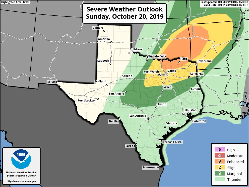
Here’s the latest severe weather outlook from the Storm Prediction Center. The exact line placements will probably change somewhat throughout the day. All I want folks to focus on is if they are in or near any of the risk zones. If so that’s your cue to keep an eye to the sky and an ear toward a weather warning source tonight.
Don’t get fixated on the exact placement of each specific risk. A higher risk level simply means a higher chance of severe weather in your area tonight. Any risk level means there is a risk of severe weather in your area tonight. Storms don’t care about our lines and they certainly feel no obligation to stay in them.
An isolated severe thunderstorm may occur after 5 PM in Texoma or North Texas. However, a strong cap will likely prevent thunderstorm development until after 7 PM – perhaps closer to 9 PM.
Rapid thunderstorm development is anticipated between 9 PM and 12 AM in the proximity of a southward moving cool front in Texoma and North Texas.
Strong wind shear and a moderately unstable atmosphere should support organized thunderstorm modes. We could start with a supercelluar storm mode before a squall line rapidly forms. That squall line could contain mixed convective modes (a few supercelluar storm structures along with a linear mode).
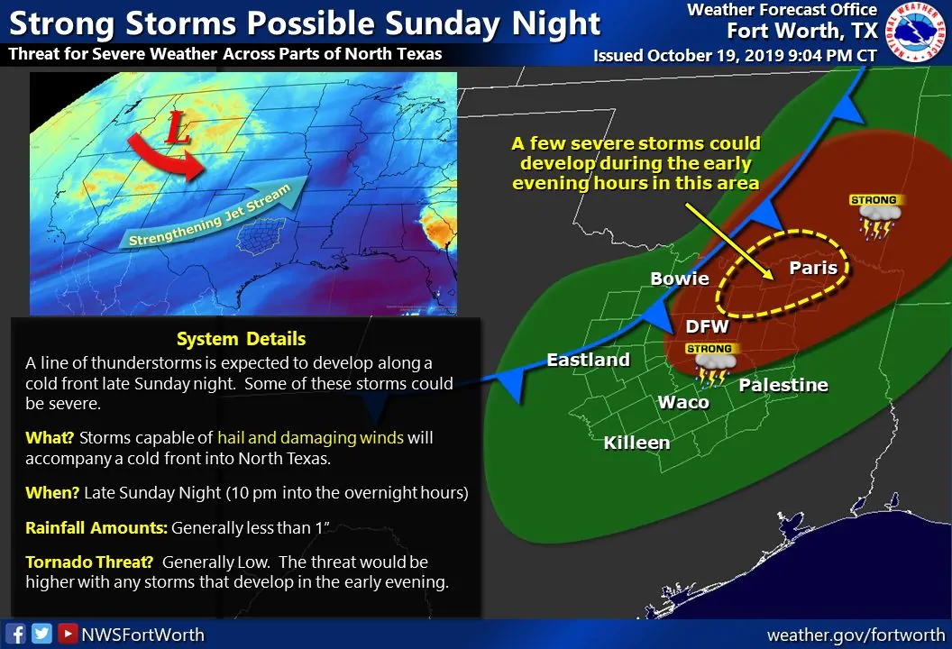
Any supercellular thunderstorms that form between 5 PM and 10 PM could be capable of producing very large hail up to the size of a baseball, straight-line wind gusts over 70 MPH, and the possibility of a tornado. This threat would be highest across Texoma (Southern/Southeastern Oklahoma south into the Red River Valley). We may not see many thunderstorms in Texas until after 10 PM, perhaps a bit later.
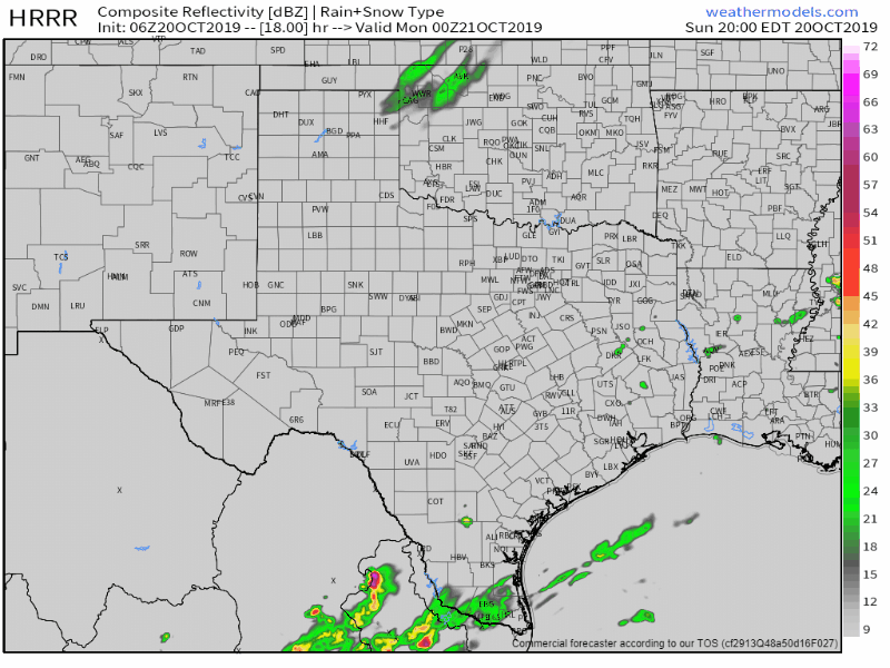
High-Resolution Rapid Refresh (HRRR) simulated weather radar beginning at 7 PM tonight. Each frame progresses forward two hours. The animation ends after the Monday morning commute. This simulation probably will not get the forecast 100% right, so don’t take it completely to heart.
A rapid uptick in thunderstorm coverage is anticipated after 10 or 11 PM in North Texas. This would generally be in a corridor from near Mineral Wells to Gainesville. Severe thunderstorms should already be underway north of the Red River. These storms will be in proximity of a southward moving cool front.
By midnight a broken to a solid line of strong to severe thunderstorms may be underway from near Mineral Wells to Denton to Sherman or Bonham. The strongest storms will likely be severe and capable of producing damaging straight-line winds along with large hail. A tornado cannot be ruled out, especially with storms close to the Red River.
The cool front will ‘unzip’ farther southwest after midnight to 3 AM Monday. We’ll likely see a nearly solid line of thunderstorms fire up from the Concho Valley and Hill Country northeast to Arkansas by 2 AM. Some of these thunderstorms will likely be severe during this time with damaging winds and large hail. The highest potential for severe storms will be across North Texas and Northeast Texas where brief tornadoes may also occur during this timeframe.
By 5 AM Monday, a nearly solid line of thunderstorms should be approaching the San Antonio Metro northeast to College Station to Shreveport. The threat of large hail will be on the decrease during the pre-dawn hours, but gusty to damaging winds will remain a threat – especially across Northeast Texas into East Texas.
By sunrise Monday a line of strong thunderstorms should be moving into Southeast Texas and Far East Texas. This includes the squall line making it into the Houston metro during the morning commute, maybe just after. Some storms may still be marginally severe with wind gusts over 60 MPH and quarter size hail.
The threat of severe thunderstorms will exit Texas to the east and southeast by late Monday morning or Monday afternoon. While some activity may continue in South Texas we’ll see a reduction in wind shear. That’ll help keep the threat for severe storms much more limited.
You’ll be able to keep tabs on the storms tonight with our free HD interactive weather radar here on our website. Some of the team will likely be out chasing while yours truly will probably be staying back to bring digital weather coverage.


0 Comments