
The forecast for tonight’s severe weather threat remains on-track with minimal changes. Those who read our morning blog will find most of the forecast remains identical.
Please do not pay too much attention to the exact placement of the risk zones. Pay attention if you’re in or near any risk zone.
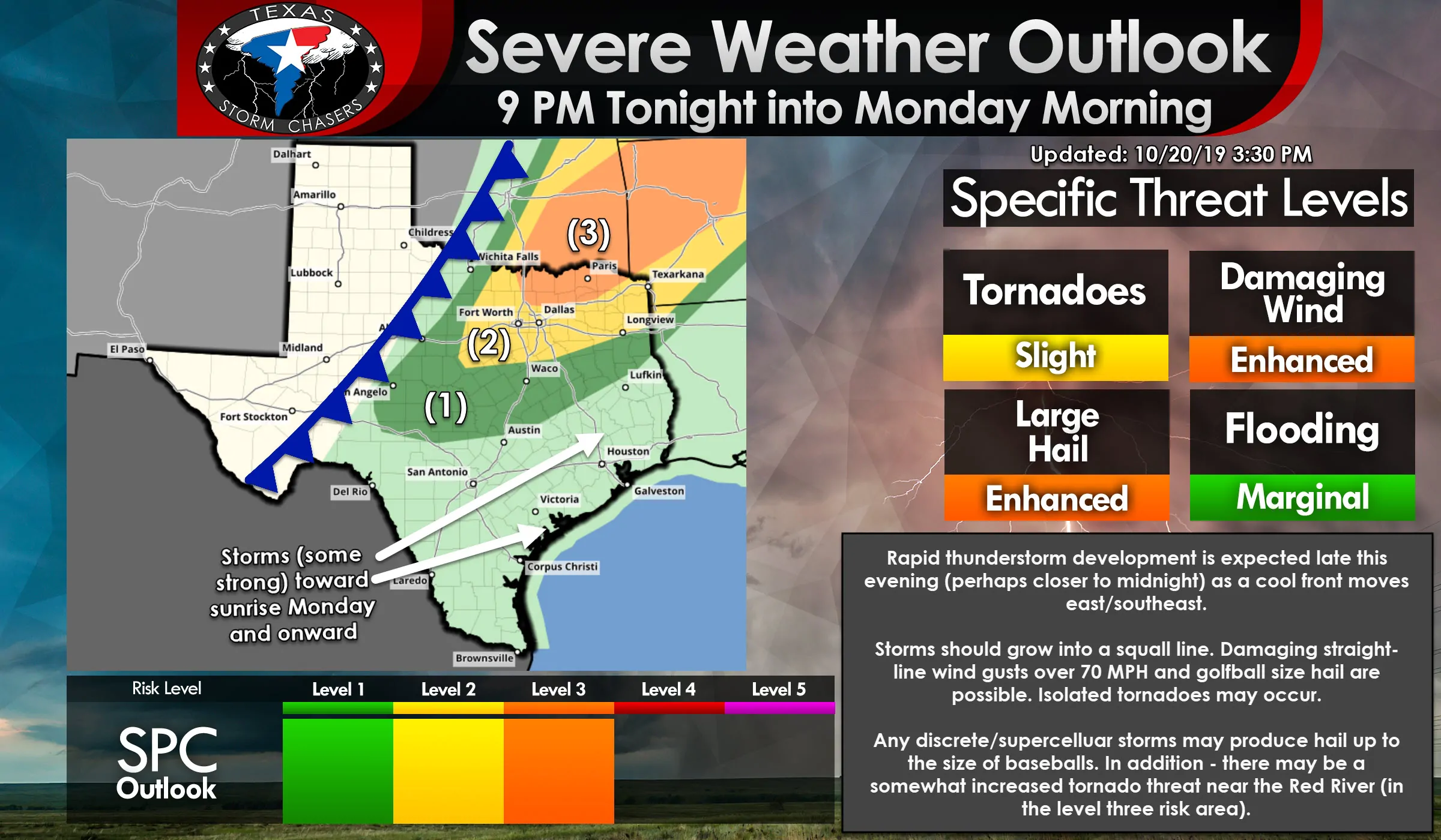
A level 3 risk of severe weather runs north of a Muenster to Denton to Allen to Greenville to Cumby to De Kalb line. Those near or within this zone have a 30% chance of severe storms within 25 miles of their location tonight. The strongest storms may be capable of producing very large hail up to the size of baseballs, straight-line winds over 70 MPH, and the possibility of a few tornadoes.
A level 2 risk of severe weather encompasses much of North Texas and portions of East Texas. It runs east of a Bellevue to Bryson to near Rising Star. From there it runs north of a line from Comanche to Hillsboro to Corsicana to Kilgore to Scottsville. Those near or within this zone have a 15% chance of severe storms within 25 miles of their location tonight. The strongest storms may be capable of producing very large hail up to the size of tennis-balls, straight-line winds over 70 MPH, and the possibility of isolated tornadoes.
A level 1 risk of severe weather includes the eastern Big Country, the eastern Concho Valley, much of the Hill Country and Central Texas, east into the northern Brazos Valley. Those near or within this zone have a 5% chance of severe storms within 25 miles of their location tonight. The strongest storms may be capable of producing hail up to the size of half-dollars, straight-line winds over 60 MPH, and a very low risk of a brief tornado.
While not shown, the risk for strong thunderstorms does extend south into the Coastal Plains and Southeast Texas for Monday morning.

High-Resolution Rapid Refresh (HRRR) Simulated Weather Radar from 7 PM this evening through the Monday Morning Commute.
Isolated thunderstorms may occur after 7 PM in the Arklatex. While a low probability, we’d have to watch those storms for signs of rotation.
Otherwise; we expect we’ll have to hold off until after 10 PM for thunderstorm development near/ahead of a cool front in North Texas and Texoma. Thunderstorms may become strong to severe rather quickly after they develop. Development would likely occur in western North Texas. Those storms would move east/southeast into the D/FW Metroplex toward midnight.
A mixed convective mode is anticipated this evening. Semi-discrete storms in North Texas and Texoma will likely attain supercelluar characteristics. Very large hail up to the size of baseballs and wind gusts over 70 MPH are possible with the strongest of those storms. A tornado threat may exist with any sustained, intense supercell in Texoma this evening. We note that some of those storms may impact the D/FW Metroplex after 11 PM.
Additional storms will fire up along the cool front around midnight. That’ll result in a squall line extending from the Concho Valley northeast into North Texas and Northeast Texas. The strongest storms in that squall line may produce damaging straight-line winds over 75 MPH, golfball size hail or larger, and the threat for isolated tornadoes. Brief tornadoes in conjunction with hurricane-force straight-line winds may occur in more intense portions of the squall line.
A squall line will move southeast into the Hill Country, Central Texas, the Brazos Valley, and East Texas during the pre-dawn hours Monday. Some storms will likely be strong to severe with damaging wind gusts and perhaps some hail. The severe weather threat will be lower than in North Texas and Texoma this evening, but will still exist on a more isolated basis.
Hydrological impacts (heavy rainfall) will likely remain limited given fast storm motions and the lack of recent widespread rainfall. Isolated flash flooding could occur, but would remain short in duration.


0 Comments