
We’re starting winter early this year after an annoyingly hot and humid summer. I’ve just started blaming it all on it being ‘2019’. It isn’t a logical explanation but it has been a weird year in the weather department. An arctic cold front will arrive in Texas tonight and tomorrow. This front will bring well below average temperatures to all of Texas for the final days of October. We’ll also have (another) winter weather events, rains, and a few stronger storms. If all that wasn’t enough fun – record low temperatures and an early end to the growing season are expected for many spots on Thursday and Friday mornings.
Isolated severe storm chances overnight into Wednesday morning

Showers and isolated thunderstorms will increase in coverage tonight into Wednesday morning across the eastern half of Texas. Some of these thunderstorms may produce small hail. There is a low risk of isolated severe thunderstorms after midnight. Those isolated severe storms would be capable of producing brief instances of quarter size hail. A slim chance for a brief tornado and damaging wind gust can’t be ruled out along the immediate Coastal Plains. Those two severe weather hazards will depend on if any storms fire up in the surface-based instability axis along the immediate coast.
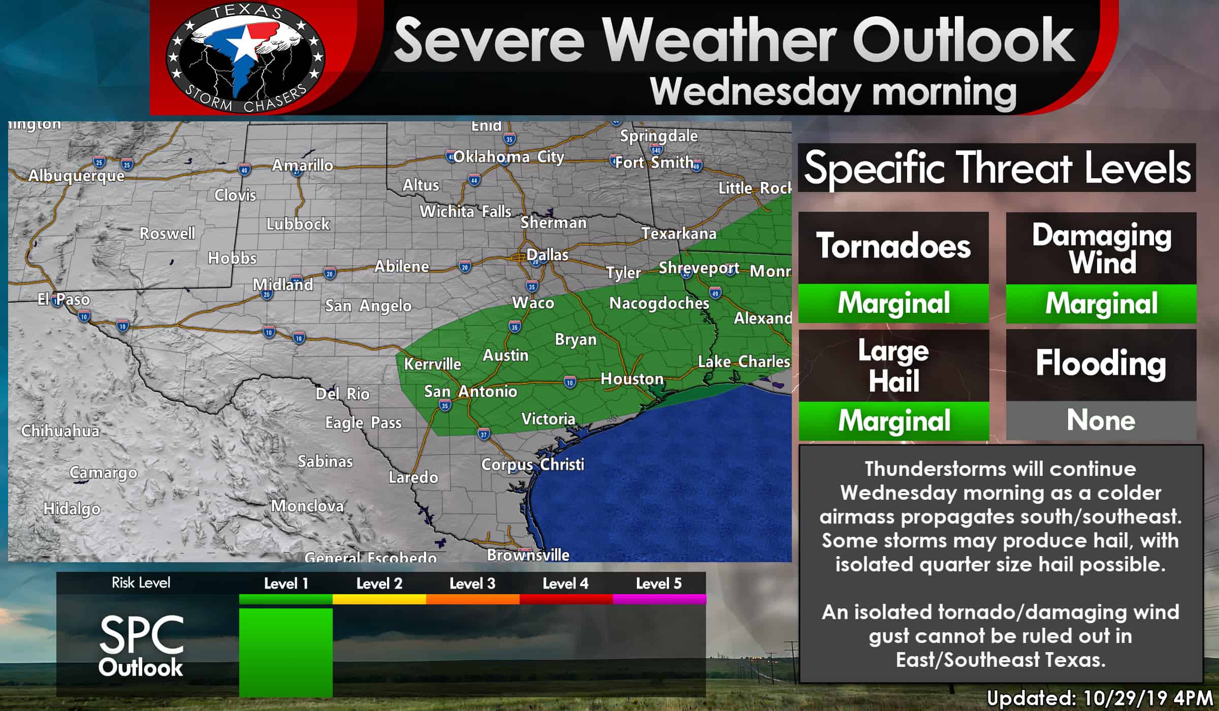
Isolated severe thunderstorms are possible Wednesday morning in the Hill Country, Central Texas, the Brazos Valley, Southeast Texas, and East Texas. Similar to tonight’s hazards, the strongest storms could produce quarter size hail. There is a very low risk of a brief tornado or damaging wind gust in East Texas before storms move out during the afternoon hours. The threat of stronger thunderstorms will come to an end by tomorrow evening.
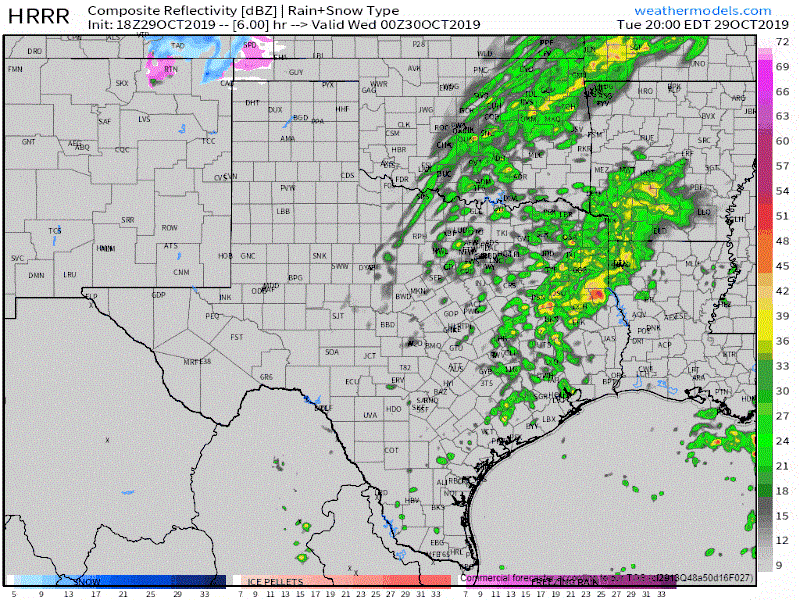
Simulated weather model radar from the High-Resolution Rapid Refresh (HRRR) weather model from 7 PM tonight through 10 PM Wednesday. This is only a model simulation and should be used accordingly.
Winter weather returns tonight
A Winter Weather/Travel Advisory is in effect tonight through lunch-time on Wednesday for all of the Texas Panhandle and much of West Texas. This advisory includes Dalhart, Perryton, Dumas, Borger, Amarillo, Pampa, Clarendon, Hereford, Dimmitt, Childress, Plainview, Littlefield, Morton, Matador, and Lubbock. A Winter Weather Advisory means that periods of snow, sleet, or freezing rain will cause travel difficulties. Be prepared for slippery roads and limited visibilities, and use caution while driving.
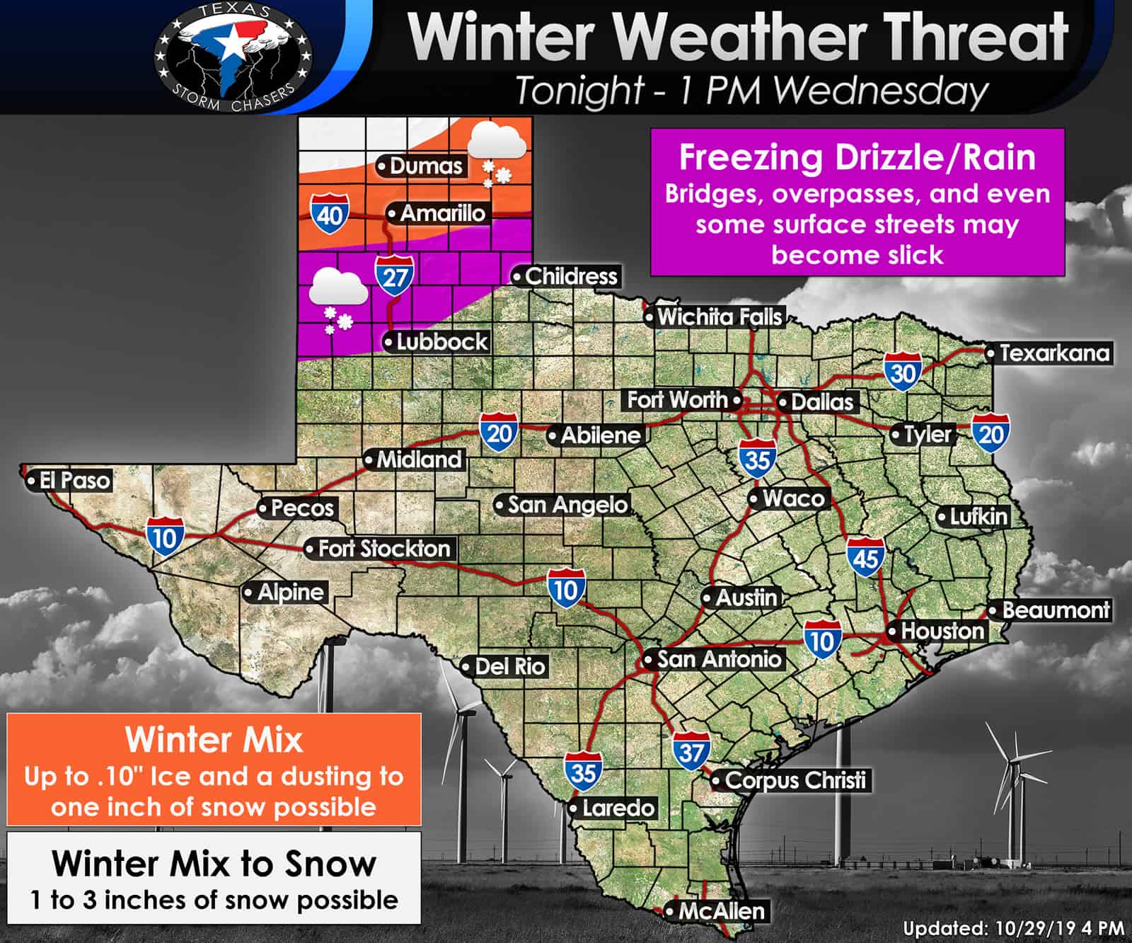
Periods of freezing drizzle or light freezing rain will develop across West Texas and the Texas Panhandle tonight and continue into Wednesday morning. With surface temperatures below freezing, we are anticipating that ice will lightly accumulate on most exposed objects. Bridges and overpasses will be the first to collect ice. Surface roadways may also begin accumulating ice in more substantial pockets of freezing rain. It only takes 0.01″ of ice accumulation to turn a road into a skating rink. Some roadways may become slick and hazardous.
Mixed winter precipitation will develop late tonight across the Texas Panhandle. That messy precipitation mode will continue into the morning hours Wednesday. As colder air arrives, the atmosphere will switch over to all snow from north to south across the northern Texas Panhandle. One to three inches of snow is expected in the far northwestern Texas Panhandle (Dalhart). One to maybe two inches of snow could occur north of a Channing to Borger to Lipscomb line. The remainder of the Texas Panhandle could have minor snow accumulations on a more isolated basis. Please keep in mind these snow totals are in addition to the light ice accumulations mentioned previously. Slick and hazardous travel conditions are possible given frigid temperatures filtering in from the north.
Winter precipitation will conclude early Wednesday afternoon. However, temperatures will fall into the single digits and teens tomorrow night across the Texas Panhandle. Any roads that experience winter accumulations will not see much improvement until Thursday (excluding treatments conducted by TxDOT).
Early season arctic outbreak to bring record low temperatures.
A straightforward way to describe the upcoming stretch of weather is that December will arrive early this year. Several locations are in jeopardy of setting new record low temperatures over the coming days. Low temperatures Thursday morning will fall dangerously close to zero in the northern Texas Panhandle. Wind chill values will quickly drop below zero and into the negative single digits. That’s quite cold for the middle of winter, not to even compare it to Haloween morning. Temperatures down into the twenties are expected in Northwest Texas, western North Texas, and the Concho Valley. By Friday morning, the freezing line will make it south into the Brazos Valley and the Hill Country. Those locations don’t typically receive their first freeze of the season until middle November (sometimes later). South Texas and Southeast Texas will experience well below average temperatures into the 30s and 40s.
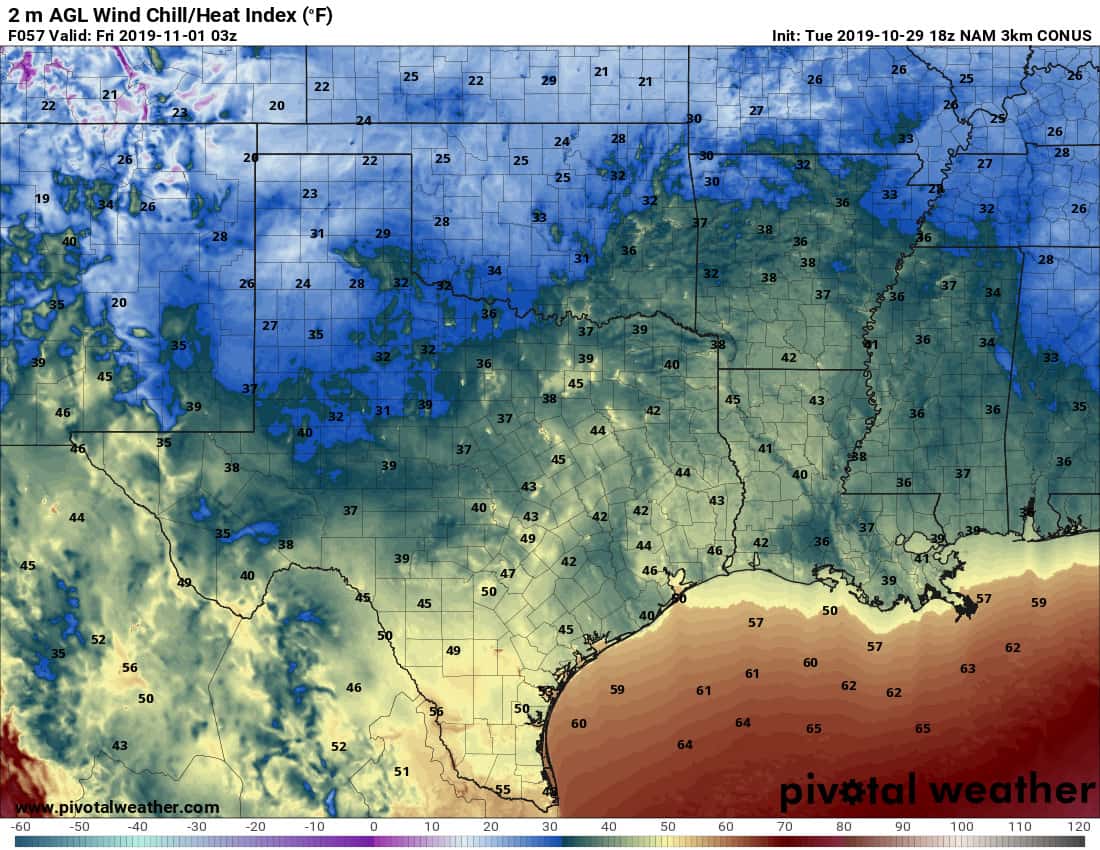
Weather model projected wind chill values at 10 PM Thursday (so add a few degrees for those out and about a bit earlier in the evening)
This year’s ‘Trick or Treat’ weather forecast will be among the more chilly we’ve seen in recent memory. Temperatures and wind chill values will be in the 20s across the Texas Panhandle and West Texas with 30s and 40s across the remainder of Texas. Plan on having jackets on under or over those costumes!
We’ll start warming up as we move into the weekend. Temperatures will still be below-average, but more fall-like versus jumping straight into winter.


0 Comments