
With one week left in October, I can comfortably say we’re going to be ending the month like a lion. Tornadoes started this week, and today we’ll be introducing a (very) early-season winter storm, and lots of rain as a strong cold front plunges south through Texas. Yes, you read that right. We’re talking accumulating snow in today’s forecast for parts of the Texas Panhandle. That’s where we’ll start this morning.
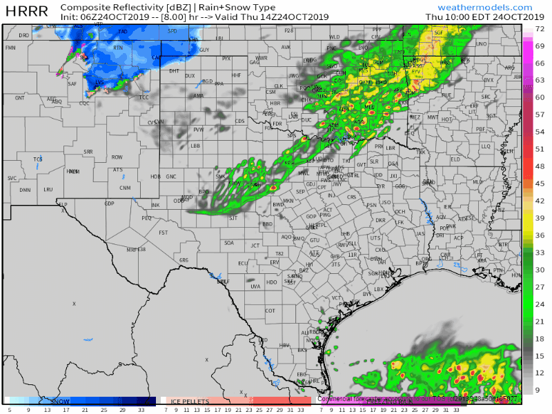
Click any image in this post for a full screen version. This is the early morning run of the High Resolution Rapid Refresh (HRRR) model. This product is a simulated radar animation from this morning through 6 AM Friday. While the exact timing and placement may not be right, this does provide a rough estimate and timetable.
Early season winter storm impacts some of the Panhandle today
The first average date of measurable snowfall in Amarillo is around November 25th. One has to fast-forward to December 11th for the average first inch of snowfall accumulation in Amarillo. Thanks to Dr. Stephen Bieda (Science Operations Officer) with the National Weather Service in Amarillo for those statistics. It is entirely plausible that we’ll end up hitting both of those thresholds today.
Today’s winter weather event in the Texas Panhandle will start this morning as all rain. Temperatures will quickly drop into the 30s as strong north/northeasterly winds arrive behind the cold front. In the mid-levels and upper-levels of the atmosphere, we’ll have a dynamic storm system aloft. That upper-level storm system will have copious amounts of cold air overhead accompanying it.
Similar to last winter’s localized winter storm in the Big Country, we are expecting dynamic cooling aloft to play a critical role in today’s changeover from rain to heavy, wet snow. Frigid air aloft will result in the atmospheric column cooling from the top down. Temperatures within the lowest few hundred feet may remain *just* above freezing, but all that sub-freezing air above will allow snow to make it to the surface.
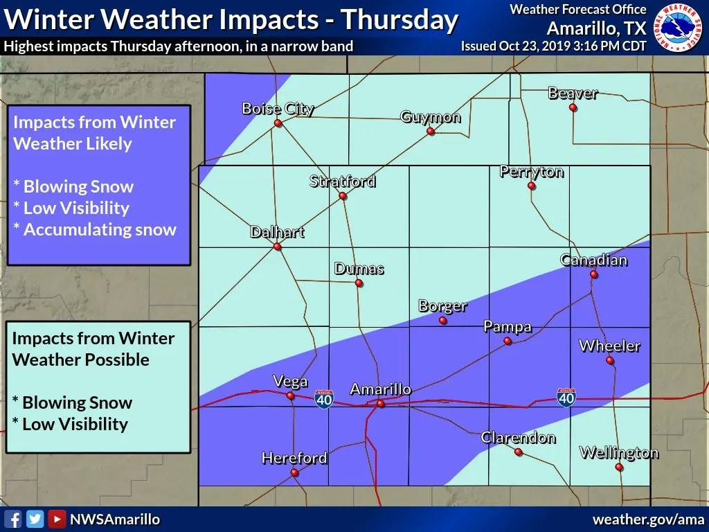
Texas Panhandle
These dynamically-driven setups can result in localized, but heavy bands of snowfall. Even if surface temperatures remain in the 33 to 35-degree range, some folks are likely going to receive a few inches of wet snow this afternoon and this evening. Soil and ground temperatures are warm, too, and that will promote the melting of the falling snow.
However, where we see heavy bursts of snow occur, that snow will accumulate faster than the warm ground can melt it. 1 to 4 inches of wet, slushy snow is expected to gather on most surfaces where we see any localized, heavy snow axis develop today. I cannot rule out some snowfall amounts being even higher if today’s’ snow band overperforms. Also: Thundersnow (thunderstorm producing heavy snow) may occur.
I wish I could be absolute in telling you where that axis will set up, but I can’t. They’ll be localized, so any shifts to the north or south would result in a sharp gradient between a dusting of snow versus several inches, including on roadways. We may see a larger area of light to moderate snowfall occur across the Texas Panhandle by the late morning through the afternoon hours.
Again, warm ground temperatures should keep the snow melting, but it may take a bit of time if the snow comes down faster than it can melt. Some travel impacts are likely – with slick and hazardous conditions where the heaviest snow occurs today. Any roadways still wet by tonight are at risk of having ice develop as surface temperatures fall into the middle 20s.
Rain and storms across the eastern half of Texas
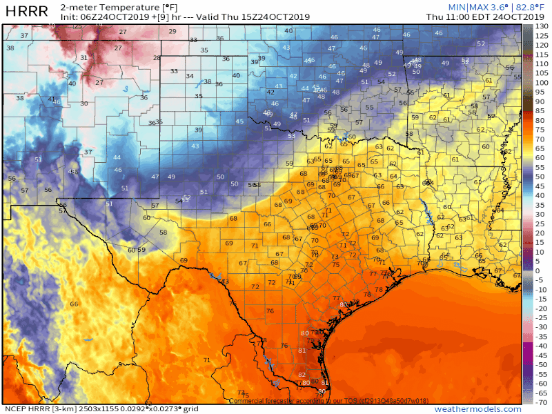
From the HRRR: Surface temperatures today as the cold front makes progress through Texas.
Farther south in Texas, we’ll be dealing with widespread shower, and thunderstorm development as the cold front continues its journey south. Numerous severe storms are not expected today.
There are several differences in the convective setup compared to this past Sunday. The atmosphere is less unstable, we have a cold front pushing south more quickly with a more potent airmass change, and it doesn’t look like storms will have a chance to organize before they are overrun by the cold front (known as undercutting). There will be just enough ‘juice’ today to support stronger storms capable of some hail and perhaps localized damaging wind gusts.
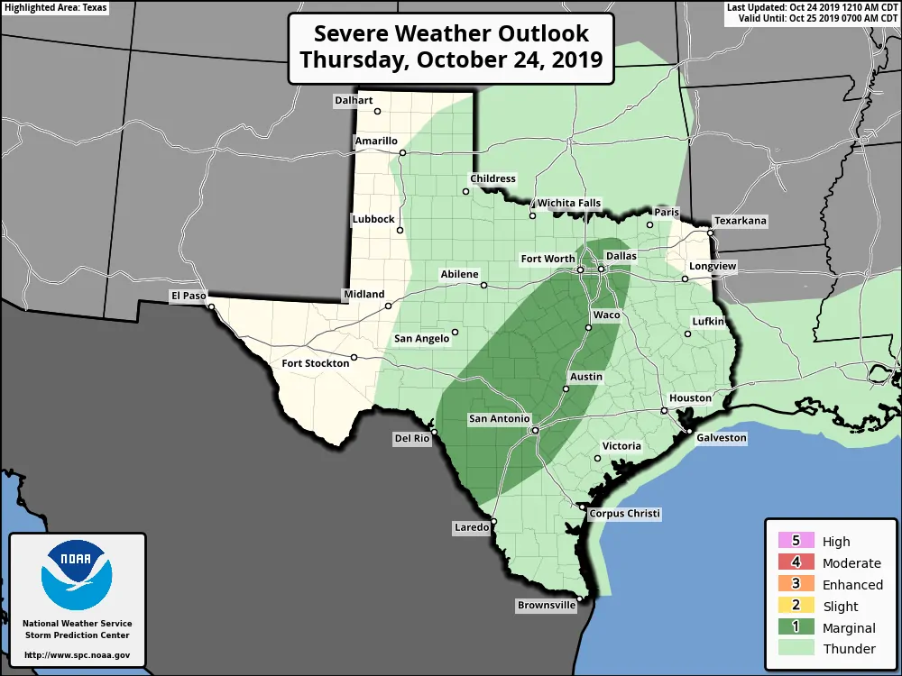
A level one risk of severe weather is in place this afternoon for the Edwards Plateau, Hill Country, Central Texas, and North Texas (generally from the D/FW Metroplex south). Today features a marginal severe weather threat with some storms along and behind the cold front producing small hail. A few storms may be able to get strong enough to create brief instances of quarter size hail. Some 50 to 60 MPH wind gusts could occur with the strongest storms along the leading edge of the cold front.
Tornadoes are unlikely today. I’ll never completely rule out a brief tornado given Mother Nature’s tendency to throw that back in our face, but the risk is minimal today.
Timing for any stronger storms looks to be from about lunchtime in the west/north toward dinner-time in the south and southeast. Numerous showers and thunderstorms will continue along and behind the cold front tonight, but that looks like a good soaker versus an ‘I’m going to throw hail at your bald spot” situation. Speaking as someone with a bald spot on their head, take it from me that having it targeted by hail is not pleasant.
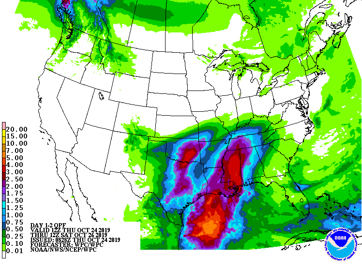
Potential rain totals over the next two days
Widespread showers and thunderstorms are expected today, tonight, and into Friday across the eastern half of Texas. We discussed the winter-weather aspect of the Texas Panhandle in our first segment.
Widespread rainfall accumulations over the next two days look to be in the one to two-inch range. Some higher rain amounts of three to four inches are possible, but that should be an exception versus the general rule. Minor nuisance flooding, such as high water in construction zones and poor drainage areas, along with isolated flash flooding, will be possible.
Rain chances will be decreasing Friday night into Saturday morning. Much of Saturday and Sunday are looking mostly dry across Texas with fall temperatures.
A quick look at our next big weather maker
We note there is a reasonably high probability of another significant cold front arriving around next Wednesday. I only mention it because confidence is also high that Halloween will be on the cooler side of the temperature spectrum. We’ll also likely have to deal with more precipitation chances with that cold front’s arrival next Wednesday.


0 Comments