
A strong cold front will move south into and through much of Texas on Thursday and into Friday. Much colder temperatures along with gusty north winds will arrive in the front’s wake. Plentiful moisture will support widespread showers and thunderstorms across the eastern half of Texas. A line of strong thunderstorms will probably accompany the front’s progression beginning tomorrow afternoon into tomorrow evening. Some of those storms could produce hail, gusty winds, and heavy rain. Winter will be off to an early start in portions of the Texas Panhandle with a thin axis of accumulating snowfall and slick roadways possible.
Rainfall Amounts Thursday and Friday
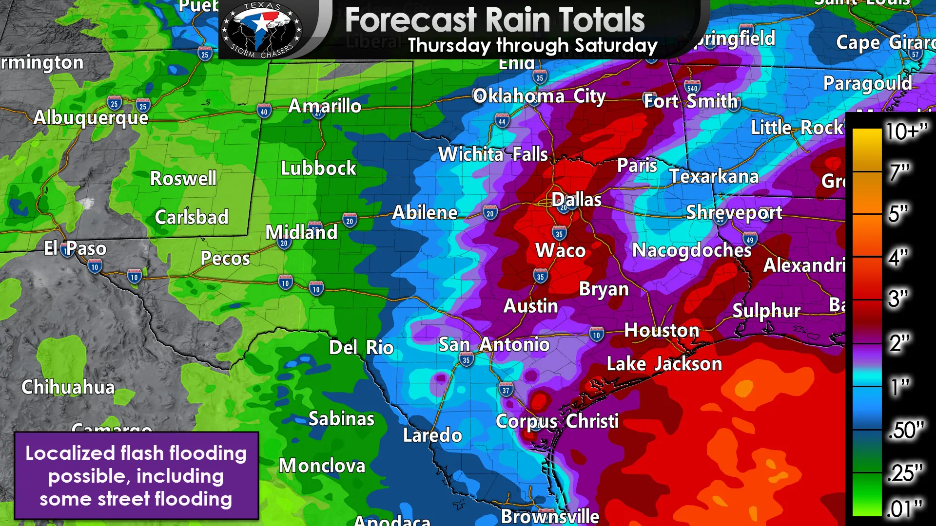
Rain accumulations will tend to average in the one to two inches are expected on Thursday and into Friday across the eastern half of Texas. Some folks will receive less, and some people could end up with rain totals closer to four inches. Isolated flash flooding is possible with the primary impacts generally in poor-drainage areas, low water crossings, and urbanized zones where water has more difficulty draining. Widespread flooding is not expected at this time. Flooded roadways are more difficult to visualize during the overnight hours. Keep that in mind if traveling in areas that experience heavy rainfall. Rain chances will decrease Friday night.
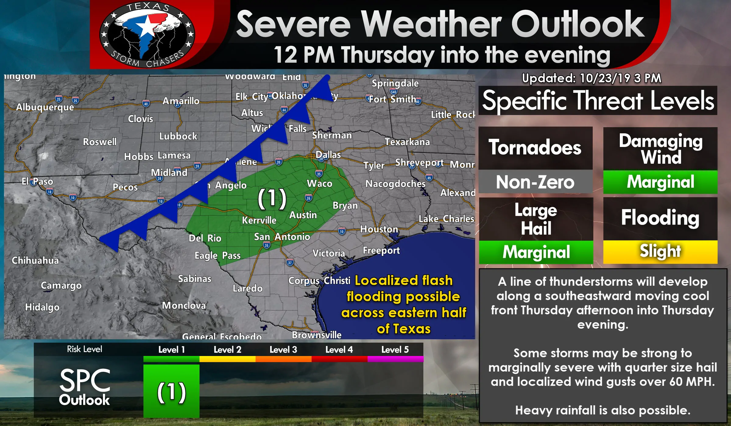
Severe weather outlook
Click the image for a full-screen version
A line of thunderstorms is expected to organize as the cold front moves south into the Concho Valley and southern North Texas late Thursday morning into early Thursday afternoon. Strong thunderstorms are expected with a marginal potential of severe thunderstorms. The strongest storms may be capable of producing quarter size hail and localized damaging wind gusts over 60 MPH. Gusty north/northwest winds are expected after the cold front arrives at any given location. I’m hesitant ever to rule out a possible brief tornado, but that threat looks to be non-zero tomorrow. Otherwise, one can expect frequent lightning, gusty winds, small hail, and heavy rain with the squall line as it moves into the Edwards Plateau, Central Texas, and Brazos Valley tomorrow afternoon and early tomorrow evening.
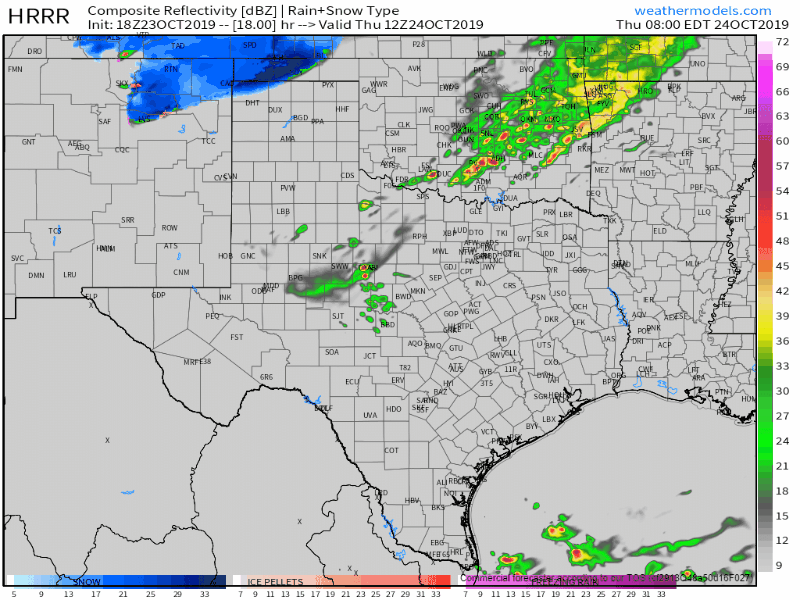
Squall line/cold front’s timing
The squall line and cold front will make fairly rapid progress to the southeast tomorrow afternoon and tomorrow evening. The immediate strong thunderstorm threat will be confined to the squall line. Rainfall may continue in the cooler air mass behind the front. That activity will not be severe, but some storms may produce small hail. The animation below is from the 1 PM run of the High-Resolution Rapid Refresh (HRRR) weather model. It runs from 7 AM Thursday and progresses forward to 9 PM Thursday. Times can be found on the top-right portion of the image. Remember those weather models are far from infallible, even the ones with better reputations.
Accumulating snowfall in parts of the Texas Panhandle
An intense upper-level low pressure, cooling temperatures behind the cold front, combined with a few other sophisticated weather features, could result in an axis of moderate snowfall Thursday afternoon into Thursday evening across parts of the Texas Panhandle and West Texas. While the upcoming winter weather event is not expected to be an event with widespread accumulating snowfall, while light snow may indeed fall, any bands of moderate snow would be confined to a narrow axis.
The small axis of heavier snow will make a specific forecast quite difficult since any shifts north or south would result in one spot getting accumulating snow while someone ten miles up the road may get little to none. Surface temperatures during the snowfall will likely remain in the 33 to 36-degree range. Frigid temperatures aloft with the aforementioned upper-level low would offset the warmer surface temperatures. That’s a fancy way of saying the snow wouldn’t have a chance to melt before reaching the surface. That phenomenon is localized under that upper-level low and where dynamics aloft are most intense. Some may remember a few snow events last winter in the Big Country that occurred under similar circumstances.
Strong north/northeast winds may gust up to 40 MPH. Even wet snow may start to blow around – reducing visibility during and after any bursts of heavier snowfall.
Soil temperatures remain warm, and that factor will also make it difficult for snow to accumulate in most locations. More substantial snowfall rates under that thin/narrow axis may temporarily offset warmer ground temperatures. One to three inches of wet snow may accumulate under that axis – including on roadways. Warm ground temperatures will result in accumulations melting not long after the snow stops falling. However, any water that remains on objects Thursday night may ‘flash freeze’ as temperatures drop well below freezing. Black ice may result in some bridges and roadways becoming slick until temperatures rise above freezing on Friday.


0 Comments