
So much for our tropical low not becoming a tropical cyclone before making landfall. What became Imelda this afternoon quickly organized an area of surface low pressure this morning. Once that occurred the system was able to rapidly organize given warm sea surface temperatures and an otherwise favorable environment. It is fortunate the system was already close to shore and didn’t have more time over the Gulf to organize. Landfall occurred near Freeport with multiple coastal weather station measuring winds of 35 to 45 MPH. Since that time the system has slowly progressed inland and now sits southwest of Pearland. As often is the case with these systems the worst impacts will be near and east of the system’s track.
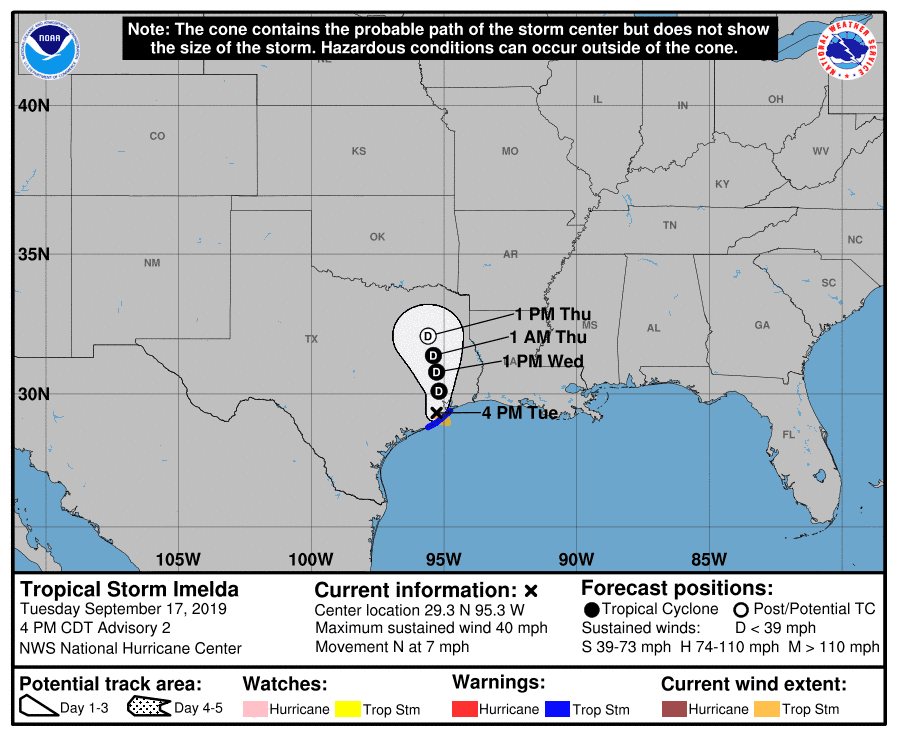
Since the system was able to quickly develop before landfall we have the added benefit of having official track forecasts from the National Hurricane Center. Their latest forecast runs through Thursday – and they have the system moving about 150 miles north by that point. It’s no secret that a tropical system moving 150 miles in three days is a classic recipe for an excessive rain event. The exact track of the low will dictate where the highest rainfall amounts materialize. Overall we have seen an eastward shift with data today with the highest rain totals expected in Southeast Texas and East Texas. Amounts will vary on a localized basis.
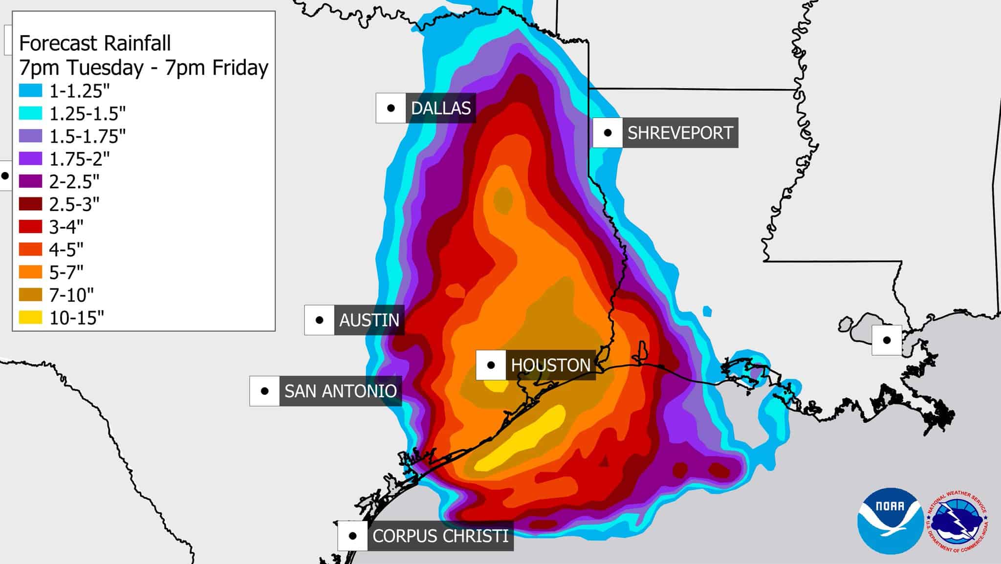
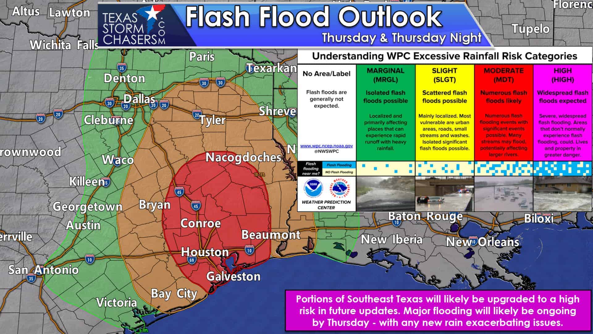
These are the latest rainfall forecasts from the National Weather Service. Again, the exact rain amount one location receives will depend on the low’s track. Any small shifts to the west or east in the system’ss track would result in a similar change in the heavy rain axis. The heaviest rains are expected to be in Southeast Texas late tonight through Thursday. Widespread rain totals of five to ten inches are expected with localized storm totals approaching fifteen inches possible.
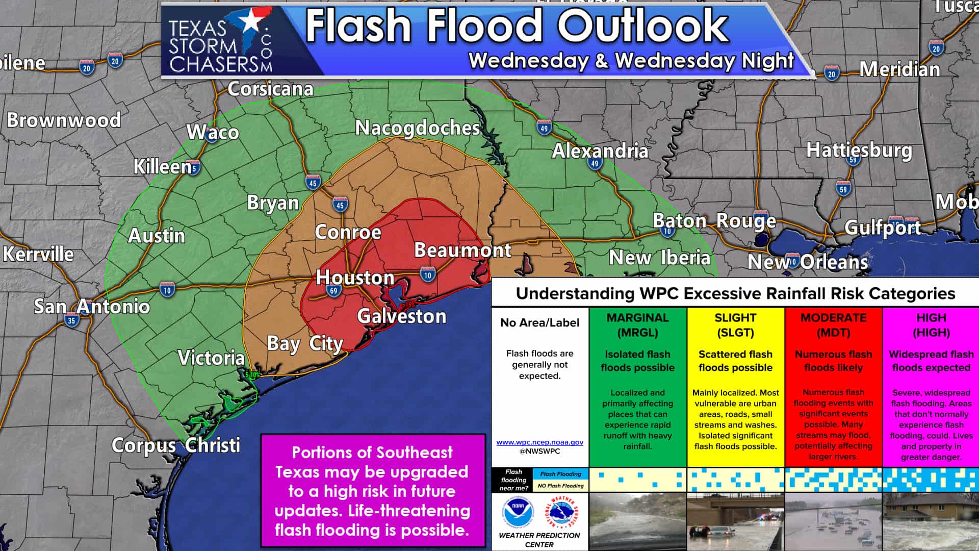
Heavy rains will also expand northward on Thursday and Friday as the low slowly moves north. Four to eight inches of rain may fall across the eastern Brazos Valley, eastern North Texas, and in East Texas. It goes without saying – but flooding will become a more significant hazard as we progress through this event.
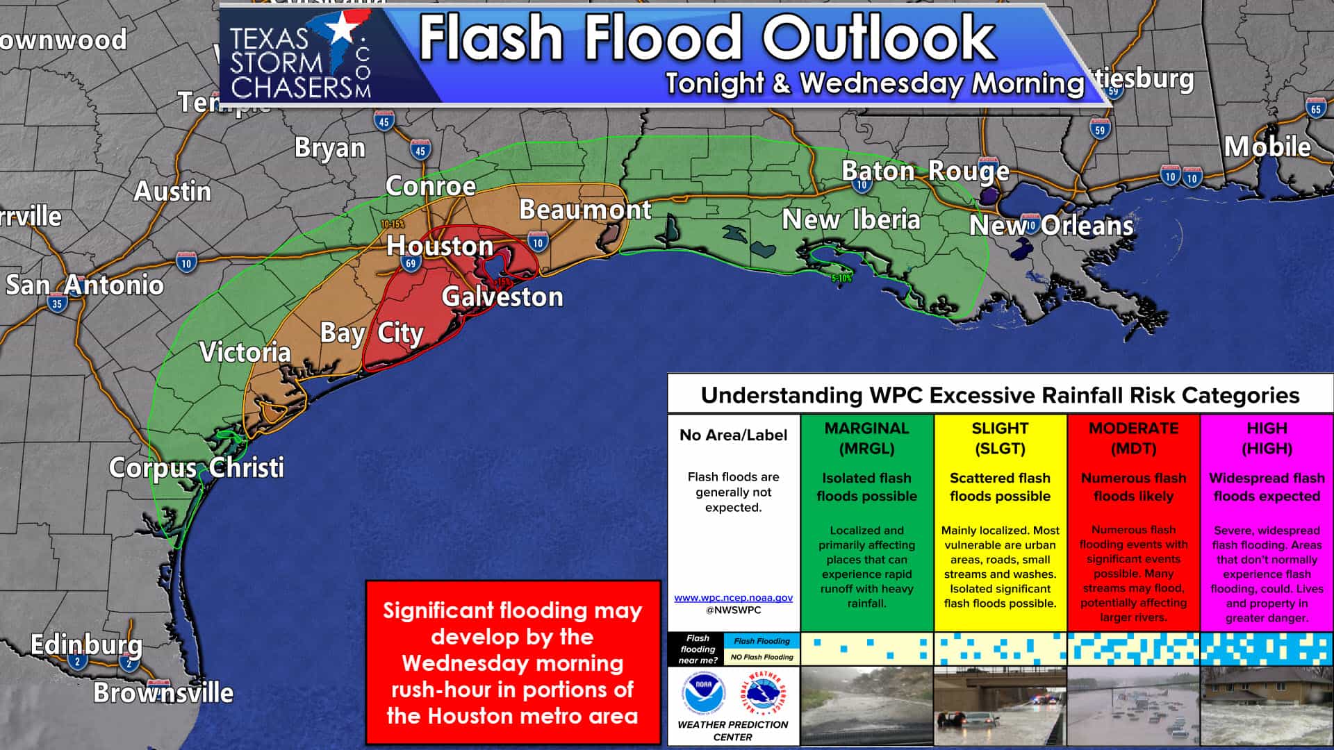
The recent dry spell will allow soils to absorb initial rains quite efficiently. However, after several inches of rain falls we anticipate soils will become saturated. Once saturation occurs any additional rain will run-off into drainage systems, and we’ll start the flash flood process. The risk of flash flooding will be highest in Southeast Texas tonight and on Wednesday – with the threat spreading north on Thursday. Life-threatening flash flooding is possible if extremely heavy rains train (or continually move) over urbanized locations.
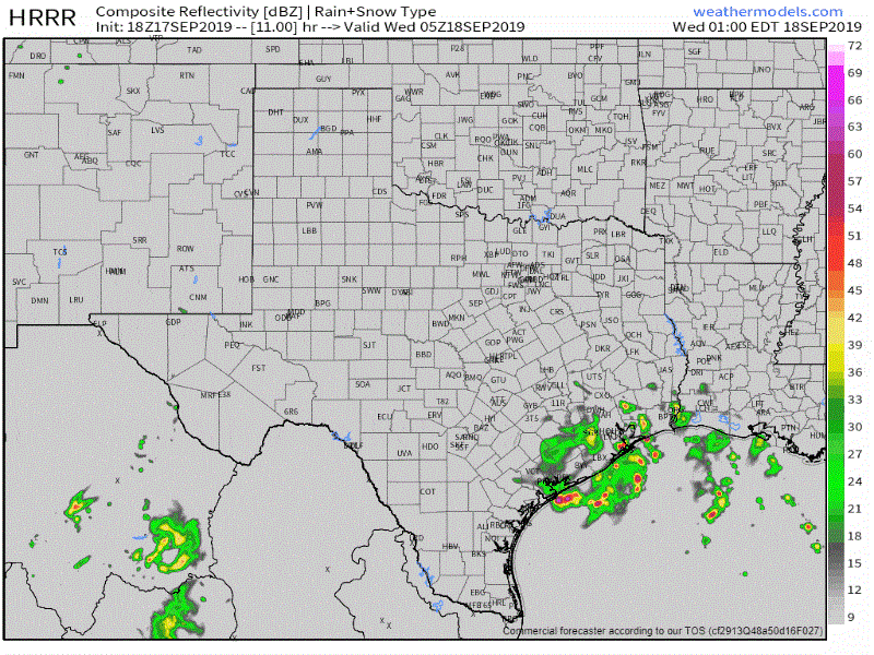
18Z HRRR: Simulated weather radar from late tonight through late Wednesday evening.
Taking one look at high-resolution weather model guidance shows why we’re concerned about flooding late tonight and on Wednesday. This one model has very heavy rainfall sitting on portions of Southeast Texas for most of the day. Hourly rainfall rates would likely range from two to five inches under the worst of that band. Sure, soils are dry now, but they won’t be for long in that kind of excessive rain. Again; the location of the heaviest rains will depend on the position of the low, so it isn’t guaranteed the location this one model has those very heavy rains is exactly spot on. Some variation is to be expected.
Once we start to have flooding develop we’ll become more active on our social media accounts. Be sure you’re following us on social media, especially our Twitter account. You can keep up with our tweets without a Twitter account here on our website (click here). That’s the platform we use most extensively during weather events. Our interactive weather radar will also be a useful asset to keep handy as we start to get busy.


0 Comments