
All eyes will be on the northwestern Gulf of Mexico today. An upper-level area of low pressure has become more organized overnight. That area of low pressure is slowly moving northwest and will make it to the coast late tonight in the Coastal Plains. Based on the increase in organization there is some potential that this system could briefly become a tropical depression later today before it moves onshore. I suppose there’s even a low chance it is able to become a minimal tropical storm. Regardless of any ‘tropical’ development, the primary impacts will continue to be excessive rainfall over the next few days as the system slowly moves north.
As a reminder: You can keep tabs on the rain over the coming days with our free HD interactive weather radar right here on our website and in our free mobile app (click the banner at the top of the page).
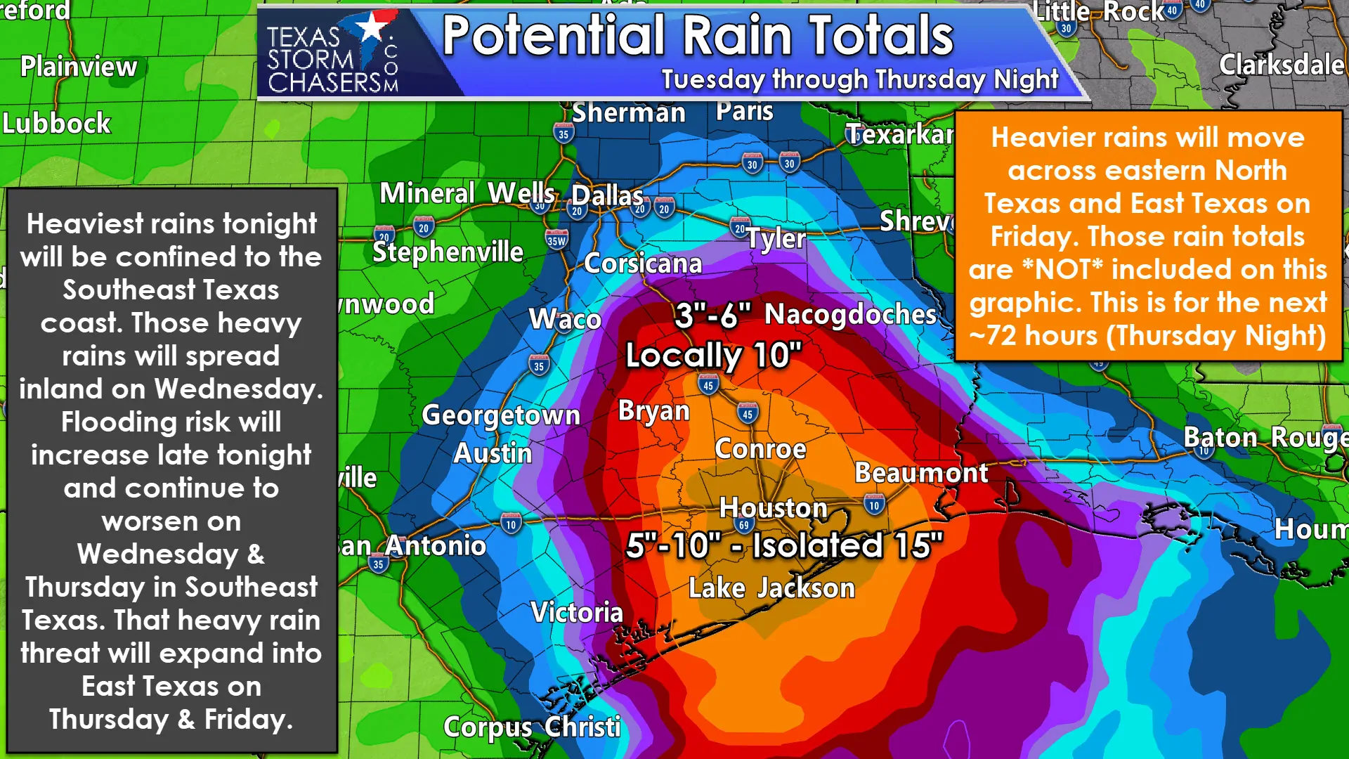
I’ll start off showing the latest 72-hour rainfall forecast from the Weather Prediction Center. These forecasts are regionalized and do not include the typical small-scale variations one might see in rain totals. Some folks will receive less and some folks could see more. This forecast is from this morning through Thursday Night. It does not include Friday – where an additional one to three inches of rain is expected to fall in eastern North Texas and Northeast Texas. For some reason my data program wasn’t wanting to display that new forecast data, so we’ll stick with the three day graphic with this morning’s post.
Widespread rain totals of five to ten inches continue to be forecast across the Houston Metro and a good portion of Southeast Texas. Localized rain totals exceeding one foot and approaching fifteen inches are possible. That is mainly from late tonight through the day Thursday. It won’t be pouring at one given location for that entire duration. There will be multiple rounds of storms with breaks in-between. The strongest/most intense activity may produce hourly rainfall rates over three inches. Get that storm to sit in the same location (or train) for a few hours and that’s how we could end up seeing someone get ten inches of rain in a few hours. That’s the kind of intense rainfall that will produce significant flash flooding – regardless of how dry it has been and especially if it happens in an urban setting.
It has been dry recently which means soils will be able to handle the initial rains. However, we anticipate soils will become saturated and eventually any additional rainfall will run-off into drainage systems. Obviously the ‘soils handling initial rain’ will go out the window if one spot receives three or four inches of rain in an hour.
All of this rain can be associated with the tropical area of low pressure that’ll only slowly move north across Texas this week. One way to think about the behavior of this system is by thinking of a ballerina. During the day-time hours, showers and thunderstorms expand outward from that low. Once we get into the night the precipitation shield will generally shrink in coverage, but increase in intensity closer to that area of low pressure. That’s why the track of this low will be important in determining the eventual axis of heaviest rainfall over the next several days. I’ll forgo the nerdy meteorological reasons why these warm-core lows behave like a ballerina, but perhaps that could make for a nice ‘Weather Wednesday’ article down the road.
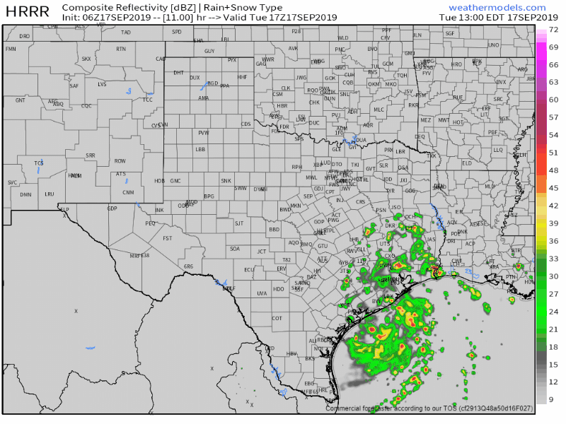
Early morning run of the High Resolution Rapid Refresh (HRRR) model showing a simulated radar loop from this afternoon through 7 AM Wednesday. Notice that this one model keeps most of the heaviest rains close to the coast through tonight. However, those on the coast and just inland could end up dealing with significant rain totals from that band. Flash flooding would be likely.
With the tropical low near the Southeast Texas coast tonight that is where we anticipate the heaviest rains to set up shop. If you loop the radar tonight you’ll likely see a band of heavy rainfall ‘sitting still’. In reality that heavy rain will be ‘training’ or moving over the same areas. Regardless we could see a corridor of 6 to 9-inch rainfall totals set up shop tonight from Port Lavaca northeast into the Houston Metro, Galveston, to Beaumont and Port Arthur. That’s not to say all those in the aforementioned corridor will get that kind of rainfall overnight, but once that heavy rain band moves onshore and parks itself – whoever is under it will be getting a lot of rain in a short period of time. Flash flooding is expected by morning where that band sets up.
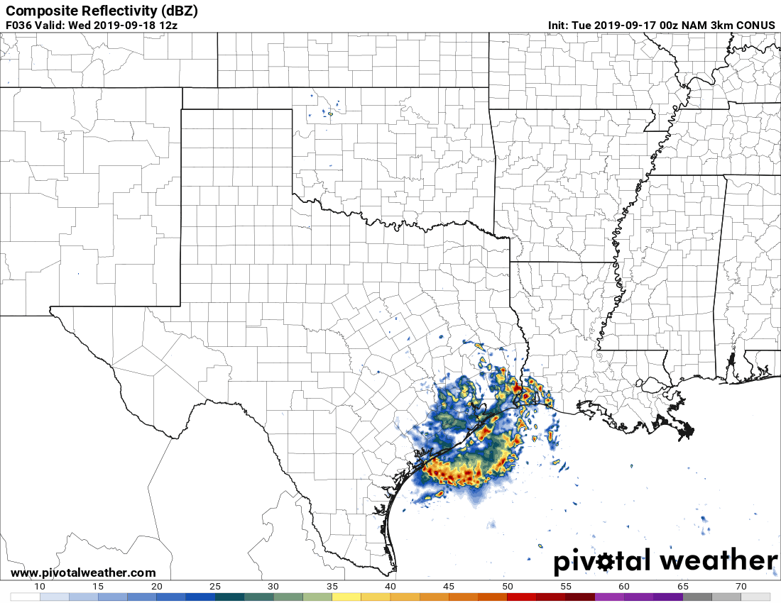
One model’s depiction of the rain bands from Wednesday morning through Thursday. This is just an example of how the rain bands won’t really move all that much – resulting in big-time rain accumulations. Where that band sets up (exactly) will determine who has the highest threat of flooding. This model may not have the locations exactly right, so don’t take this for verbatim.
As we move into the day on Wednesday the tropical low will only make slow progress to the north. At some point, we’re going to likely see that heavy rain set up shop over the Houston Metro. Hourly rainfall rates could be in the two to the three-inch range for several hours. At first, soils will be able to absorb the rain given the dry stretch of weather we’ve experienced. However, that ‘grace’ period won’t last long if rainfall rates are indeed excessively high. After soils saturate any additional rain that falls will simply runoff. Any urban setting that occurs in will likely start to experience flooding pretty fast. I’m not talking specifically about Houston proper, but the entire Southeast Texas region. Just expand that slowly north on Wednesday, Wednesday Night, into Thursday. Eventually heavier rains will begin in the Brazos Valley, and by Thursday night into Friday we’ll have heavy rains in eastern North Texas and East Texas.
Could all of this change? Yes!
One alternative scenario we’ll need to watch for is if this system actually does become a tropical cyclone or more organized than expected. That would try to push the heavier rains farther east – perhaps pushing the heaviest rain axis closer to the Lousiana border (or into Lousiana). We would still have a heavy rain/flooding threat in portions of Southeast Texas, but overall rain totals could be lower. That would be especially true for East Texas.
I’ll have my next detailed blog post written up and released in time for dinner – sooner if necessary.


0 Comments