

It has been a horrific night in the rainfall department across portions of far Southeastern Texas and the Golden Triangle. Very heavy thunderstorms have produced nearly 20 inches of rainfall in Beaumont overnight with storm totals over the last two days near 30 inches. Catastrophic and life-threatening flash flooding is ongoing with numerous flash flood emergencies underway. A television station in Beaumont has had to evacuate during the last hour due to floodwaters entering their building. There have been evacuations of homes, businesses, and even one hospital in Winnie. Countless water rescues are underway and I’m afraid we just won’t know the scope of the disaster until the sun rises and the rains stop. Heavy rains continue and will continue for a few more hours (at least). Many roadways, including Interstate 10, are underwater in spots. The aerial coverage of flooding is smaller than Harvey in 2017 with Houston being mostly dry overnight. Those just east of Houston were not so lucky.
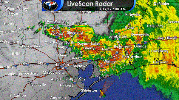
Flash Flood Emergencies have been issued for catastrophic, life-threatening flash flooding. The following towns are included: Beaumont, Port Arthur, Nederland, Port Neches, Vidor, Nome, Hamshire, Central Gardens, China, Rose City, Pine Forest, Port Acres, Orangefield, Fannett, La Belle, Southeast Texas Regional Airport, Liberty, Dayton, Ames, Daisetta, Hardin, Kenefick, Devers, Dayton Lakes, Stowell, Winnie, Hankamer, Cleveland, Plum Grove, North Cleveland, Moss Hill, and Tarkington Prairie. A flash flood emergency is issued when there is a serious threat to life and a catastrophic threat to property. The last time we had so many at once here in Texas was in August of 2017 from Hurricane Harvey.
Thunderstorms have expanded westward over the last hour and now extend from near Keenan, Willis, and Conroe east to Cleveland, LIberty, Winnie, Fannett, Beaumont, Nederland, to Orange. The strongest storms are producing 3 to 5 inches of rain per hour. Those storms are ‘training’ or moving over the same areas like a train going down a track. That’s how we’ve seen 20+ inch rain totals in the last seven to eight hours around Beaumont. 5.16″ of rain measured between 5 AM and 6 AM in Conroe (Interstate 45 north of Houston metro).
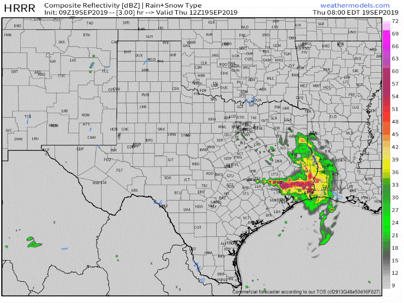
09Z HRRR model’s simulated radar from 7 AM this morning until 7 PM tonight. This is a model simulation and may not be completely correct.
The HRRR (High-Resolution Rapid Refresh) model has done an excellent job predicting the overnight events in Far Southeast Texas. We’ll share that model here now to take a look at the next several hours across the state. We note that the model has the band of very heavy rainfall north of the Houston metro moving slowly south through the morning hours. It doesn’t stall it out like the activity overnight around Beaumont, but it doesn’t have it moving too quickly either. With hourly rainfall rates of two to five inches, we could see some flooding in the Houston metro later this morning as that band slowly moves south.
The extreme rainfall rates in Far Southeast Texas should come down some after 7-8AM, but moderate to heavy rainfall may continue into the early afternoon hours with additional flooding probable. It will take an extended duration of time for water levels to recede once rains conclude.
We should see these organized ‘bands’ of heavy rain weaken by the early afternoon hours across Southeast Texas and Far Southeast Texas. That’ll give way to more scattered activity that’ll be hit or miss across East Texas, the Brazos Valley, into the Coastal Plains, and Southeast Texas. Unreleated to the ongoing rain event, we also note thunderstorms possible by the late afternoon in the Texas Panhandle and West Texas.
We’re sending out rapid-fire updates using our Twitter account. You can monitor those without leaving our website by clicking here. We also have free HD interactive weather radar here and in our free mobile app. Road conditions can be found at drivetexas.org


0 Comments