
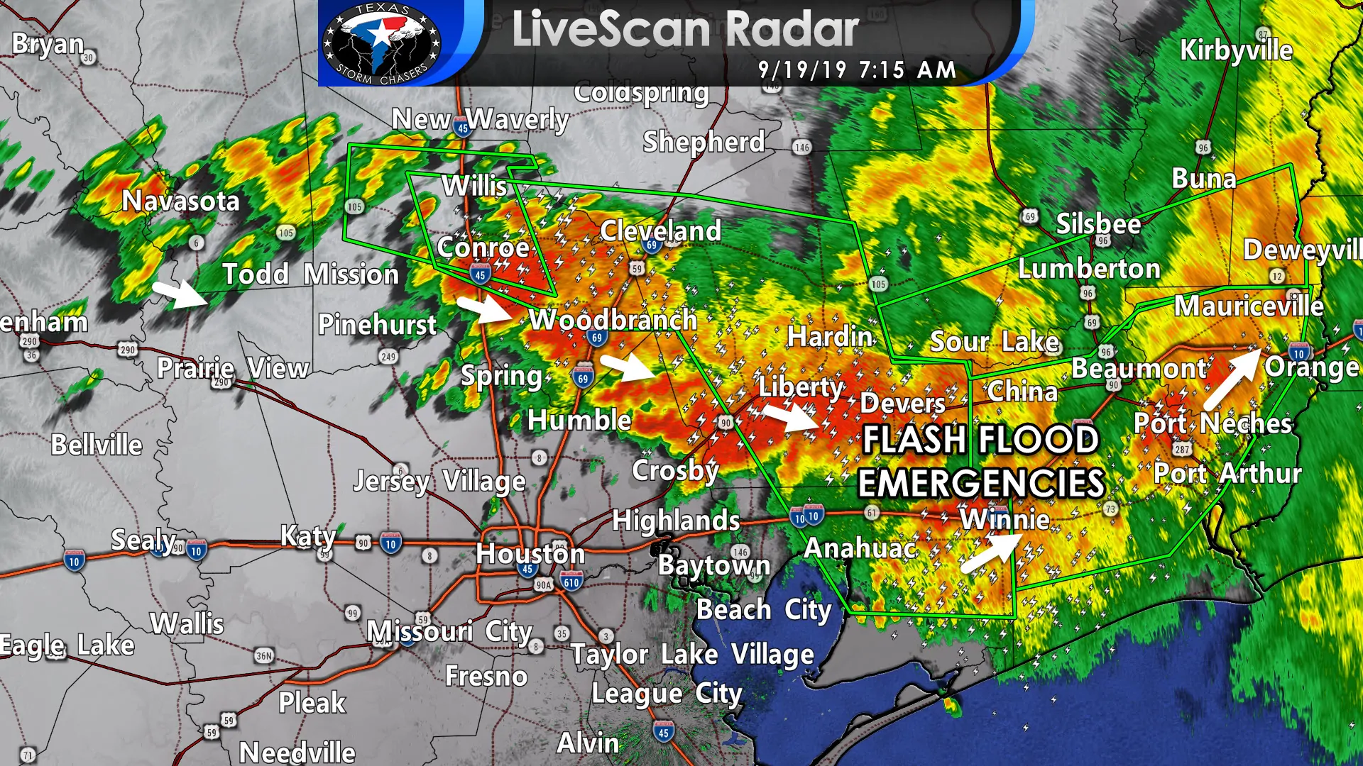
Flash Flood Emergencies have been extended in both time and aerial coverage. They now include areas just north and east of the Houston metro extending all the way to near the Louisiana/Texas border on Interstate 10. This is an incredibly dangerous, life-threatening situation. Severe to catastrophic flooding is ongoing with 10 to nearly 30 inches of rainfall observed over the last twelve hours.
Cities included in the Flash Flood Emergency: Conroe, Liberty, Cleveland, Dayton, Willis, Anahuac, Panorama Village, Splendora, Patton Village, Roman Forest, Woodbranch, Old River-Winfree, Cut And Shoot, Ames, Daisetta, Hardin, Plum Grove, Kenefick, Cove, Devers, Beaumont, Port Arthur, Orange, Nederland, Groves, Port Neches, Vidor, Bridge City, Nome, Hamshire, Central Gardens, Mauriceville, China, Rose City, Pine Forest, Port Acres, Forest Heights, Orangefield, Fannett and La Belle.
Storms are slowly starting to sag south into portions of Montgomery and Harris counties. It will not take long for street flooding to commence due to hourly rainfall rates of two to four inches. We’ll see the overall rain intensity decrease as we edge past lunch, but those in Southeast Texas into the Golden Triangle have several more hours of heavy rain to go.
We’ve got rapid-fire updated available over on our dashboard here and free HD interactive weather radar here.
Flash Flood Warning
National Weather Service Lake Charles LA
632 AM CDT Thu Sep 19 2019
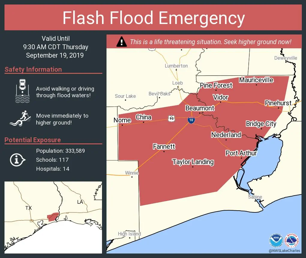
…FLASH FLOOD EMERGENCY FOR JEFFERSON AND ORANGE COUNTIES…
The National Weather Service in Lake Charles has issued a
* Flash Flood Warning for…
Jefferson County in southeastern Texas…
Orange County in southeastern Texas…
* Until 930 AM CDT.
* At 625 AM CDT, Doppler radar and automated rain gauges indicated
thunderstorms producing heavy rain across the warned area.
Jefferson County Drainage District 6 gages indicate 7 to 15 inches
of rain have fallen since last evening. Flash flooding is
occurring, with numerous roads impassable and reports of water
rescues and evacuations. Rainfall is expected to continue for the
next several hours.
THIS IS A FLASH FLOOD EMERGENCY FOR JEFFERSON AND ORANGE COUNTIES.
This is a PARTICULARLY DANGEROUS SITUATION. SEEK HIGHER GROUND NOW!
If you are caught outside and need assistance, please call 911. If
you cannot get through 911, call Beaumont Police Department at
409-832-1234, or Jefferson County Sheriff Office at 409-835-8411.
Flash Flood Warning
National Weather Service Houston/Galveston TX
700 AM CDT Thu Sep 19 2019
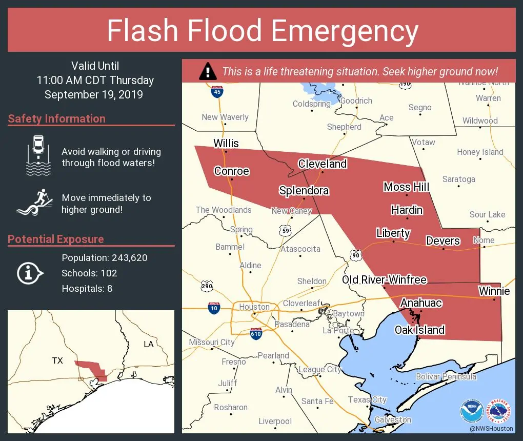
…FLASH FLOOD EMERGENCY FOR PORTIONS OF SOUTHWESTERN SAN JACINTO,
EAST CENTRAL MONTGOMERY, CHAMBERS, AND LIBERTY COUNTIES…
The National Weather Service in League City has issued a
* Flash Flood Warning for…
Southwestern San Jacinto County in southeastern Texas…
East central Montgomery County in southeastern Texas…
Chambers County in southeastern Texas…
Liberty County in southeastern Texas…
* Until 1100 AM CDT.
* At 654 AM CDT, emergency management has reported flash flooding
across the warned area. There are ongoing numerous water rescues,
structural flooding in portions of Liberty and Chambers Counties,
and numerous road closures. 10 to 20 inches of rainfall has fallen
so far with locally higher amounts in Liberty and Chambers
Counties. Additional heavy rainfall is expected.
THIS IS A FLASH FLOOD EMERGENCY FOR PORTIONS OF SAN JACINTO,
MONTGOMERY, CHAMBERS, AND LIBERTY COUNTIES. THIS IS A PARTICULARLY
DANGEROUS SITUATION. SEEK HIGHER GROUND NOW!


0 Comments