

Extreme life-threatening flash flooding is underway in portions of the Golden Triangle and Far Southeast Texas. Flash Flood Emergencies are in place for Beaumont, Port Arthur, Nederland, Port Neches, Vidor, Nome, Hamshire, Central Gardens, China, Rose City, Pine Forest, Port Acres, Orangefield, Fannett, La Belle, Liberty, Dayton, Ames, Daisetta, Hardin, Kenefick, Devers, Dayton, Lakes, Stowell, Winnie and Hankamer.
A Jefferson county rain gauge between Fannett and Winnie (just southwest of Beaumont) at 3 AM reported a six-hour rain total of 17.24 inches with a storm total of 28.11 inches. As of 4 AM, those totals are now approaching 30 inches with heavy rain continuing.
Extreme hourly rainfall rates over four inches per hour continued to be recorded with the heaviest rains. Those rains are located from Cleveland to Liberty to Winnie to Fannett to Beaumont to Vidor.
Evacuations of residences, businesses, and a hospital have been reported in Winnie.
Travel is *STRONGLY DISCOURAGED* across those areas until after sunrise. Seeing flood waters on roadways at night is extremely difficult – and more roads than not will be under floodwaters. Do not travel unless an emergency or due to finding higher ground.
Road conditions can be found on TxDOT’s website at drivetexas.org
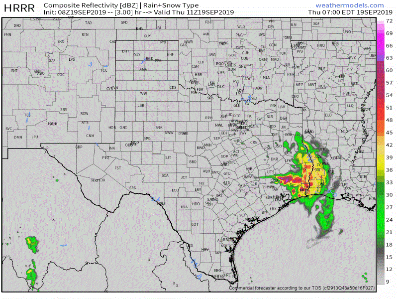
08Z HRRR – Simulated weather model radar from 5 AM to 11 AM today.
We’re monitoring new showers and thunderstorms that have been building west/northwest from Liberty to Cleveland to Willis and Conroe. The short-term high-resolution rapid refresh model is consistent in developing this band over the next several hours. If that new development occurs with such vigor as that model depicts we can expect the threat for flooding to rapidly expand westward . That threat would include the aforementioned cities into the northern Houston metro. We’ll see if that is able to happen over the next three to four hours. If it does occur we’d see a rough morning rush hour in the northern Houston ‘burbs.
We’re posting rapid-fire updates on our Twitter account. You can monitor all those without leaving our website here. We also have free interactive weather radar on our website here and in our free mobile app (banner at the top of this page).


0 Comments