
Long-time no see! With thunderstorms back in the forecast we’re back as well. Thunderstorms overnight in Oklahoma have moved south of the Red River into Texoma and North Texas. Most of these storms are not severe, but some may produce gusty winds, hail, and quite a bit of lightning. Just what folks ordered for their morning commute.. am I right? You can keep tabs on the storms with our free interactive weather radar right here on our website. Users of our app can click on the ‘radar’ button on the bottom menu.
Ongoing thunderstorms this morning should continue to weaken as they move south. Our preferred short-term high-resolution weather model indicates we should only have a few showers left by 10 AM across North Texas. However, I can’t rule out a few storms continuing given our summer-time atmosphere in place and a southward-moving outflow boundary. One positive benefit of their progression is that temperatures should be comparatively cooler today in their wake. Unfortunately, humidity values probably will still make it feel uncomfortable. We’ll have to see how storms this morning alter the atmosphere this afternoon and evening (where boundaries set up this morning could dictate where new thunderstorms form later in the day).
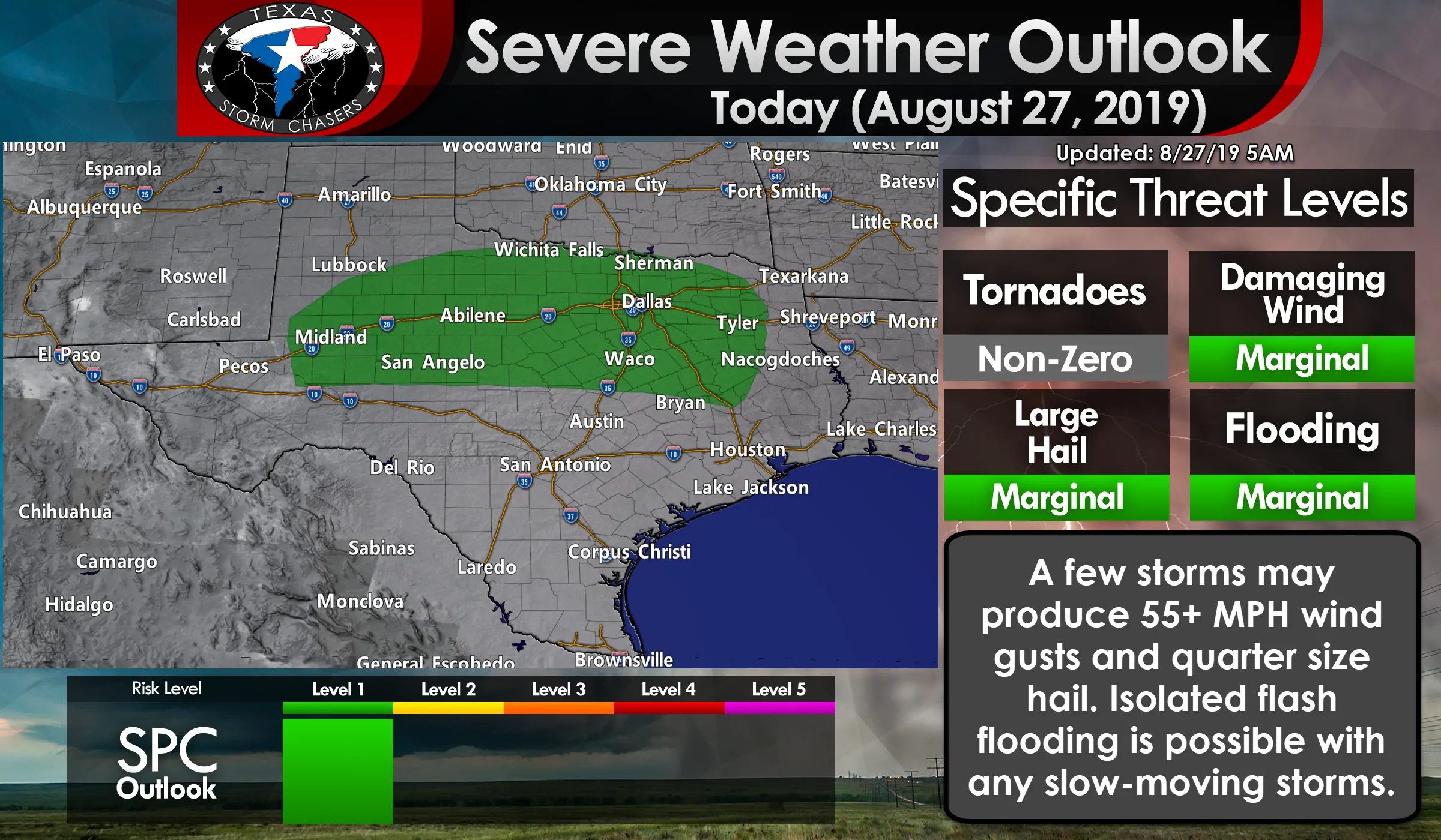
The Storm Prediction Center has outlined a level one risk of severe weather today for the Permian Basin, Big Country, northern Concho Valley, North Texas, Texoma, and northern portions of the Brazos Valley. This includes Midland, San Angelo, Abilene, Wichita Falls, Waco, D/FW, Sherman, and Tyler. Those within this zone have a five percent chance of experiencing severe weather within 25 miles of their location. These risk zones are not usually drawn for summer-time storms (which can produce damaging microbursts), so this risk indicates we could have a few more organized thunderstorms today compared to the typical ‘pop up’ summer storms.
With the strongest storms this afternoon we could see large hail and localized damaging wind gusts. I can’t rule out some decent size hail if we end up having more organized storm modes develop in the Permian Basin and Big Country later today. Storms will be slow-moving and producing heavy rainfall. Isolated flash flooding could occur. Widespread flooding and widespread severe weather are not expected at this time.
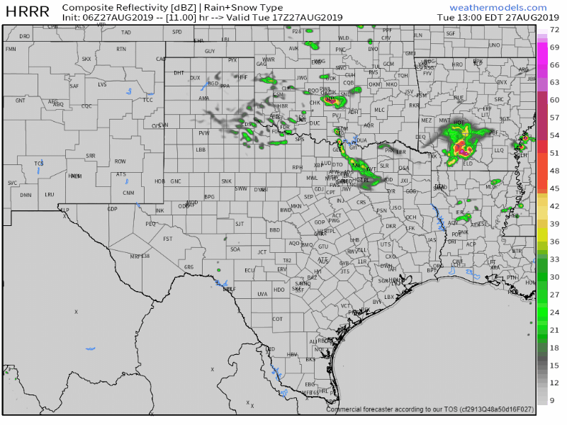
Simulated weather model radar from 12 PM today running hourly through 8 AM Wednesday. Please remember this should only be used as a general guideline – and that ‘bad data’ going into a weather model means bad data will come out. Boundaries leftover from this morning’s storms will play a role in new storm development later today, and where/how organized those storms become tonight will dictate where they end up moving tonight and into Wednesday morning. It is entirely possible this one weather model has it completely wrong – or it may be on to something. At least it provides a general timeline for you.
Isolated to scattered thunderstorms will probably develop after 4 PM to 6 PM across the Permian Basin, Big Country, Northwest Texas, and Texoma. Some of these storms could develop near residual outflow boundaries produced by storms this morning. Winds aloft will be quite weak leading to only modest amounts of wind shear. However, all the moisture (humidity) combined with summer-time temperatures will result in an extremely unstable airmass. That’ll allow for multi-cellular thunderstorm development. We may even see a few supercelluar storm structures across the aforementioned regions. Storms won’t be moving very quickly, perhaps only at 10 to 15 MPH, in various directions (dependent on storm-scale interactions and splits).
Storms should continue well into the evening hours across the Big Country, Northwest Texas, and Texoma. We may even see storms organize into one or more clusters in those regions and farther north in Oklahoma and into North Texas overnight. That activity would likely weaken and be sub-severe after midnight, but would continue into Wednesday morning across Texoma and in North Texas. Locally heavy rainfall is possible.
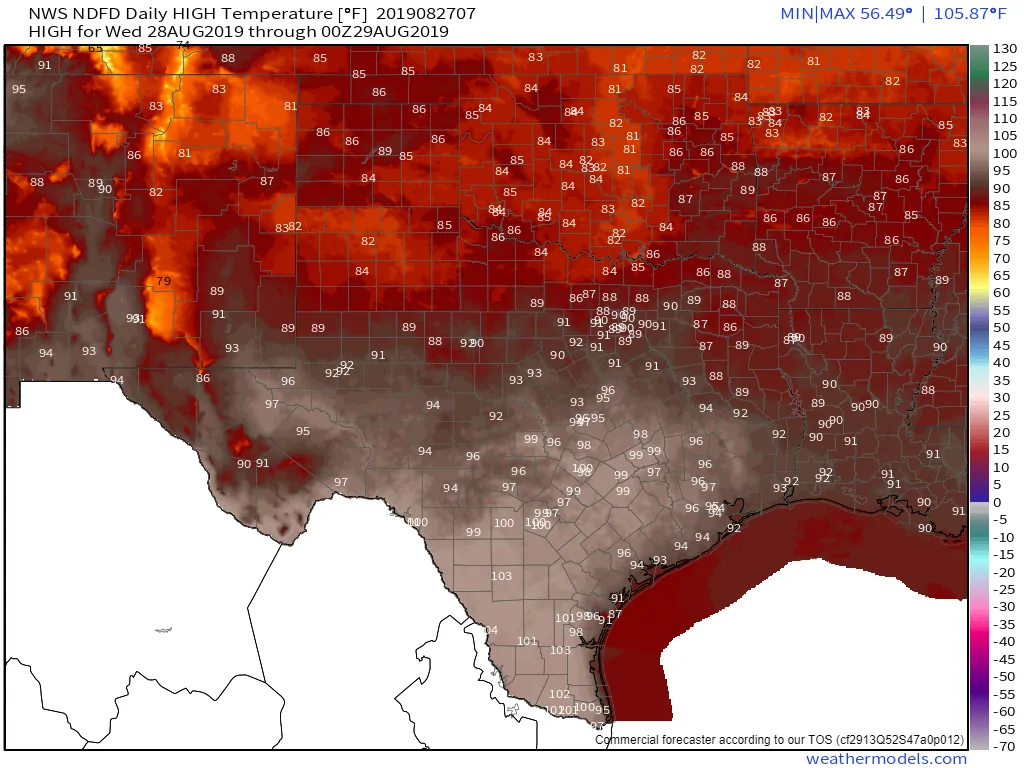
Wednesday’s high-temperature forecast
Scattered thunderstorms will continue into Wednesday as a frontal boundary slowly moves south and stalls in the Concho Valley, Central Texas, and East Texas. Those north of the front will have temperatures peak in the 80s to lower 90s on Wednesday. Those south of the front? Well, it is August. Temperatures for everyone will be back up into the 90s and 100s by the end of the workweek. We could see another small dip in temperatures by Sunday with another chance of thunderstorms. We’ll take a gander at that once we get past today.


0 Comments