
It is Friday, August 2nd, 2019 and we’re heading toward the weekend! We actually do have some weather to talk about for the weekend. While we do need some rain, unfortunately, we are talking about the chance of scattered thunderstorms for portions of Texas on Saturday and Sunday. Not everyone is going to get rained on nor will it rain all day for most folks. Increased cloud cover and those scattered storms will help bring temperatures down a few degrees for some this weekend.
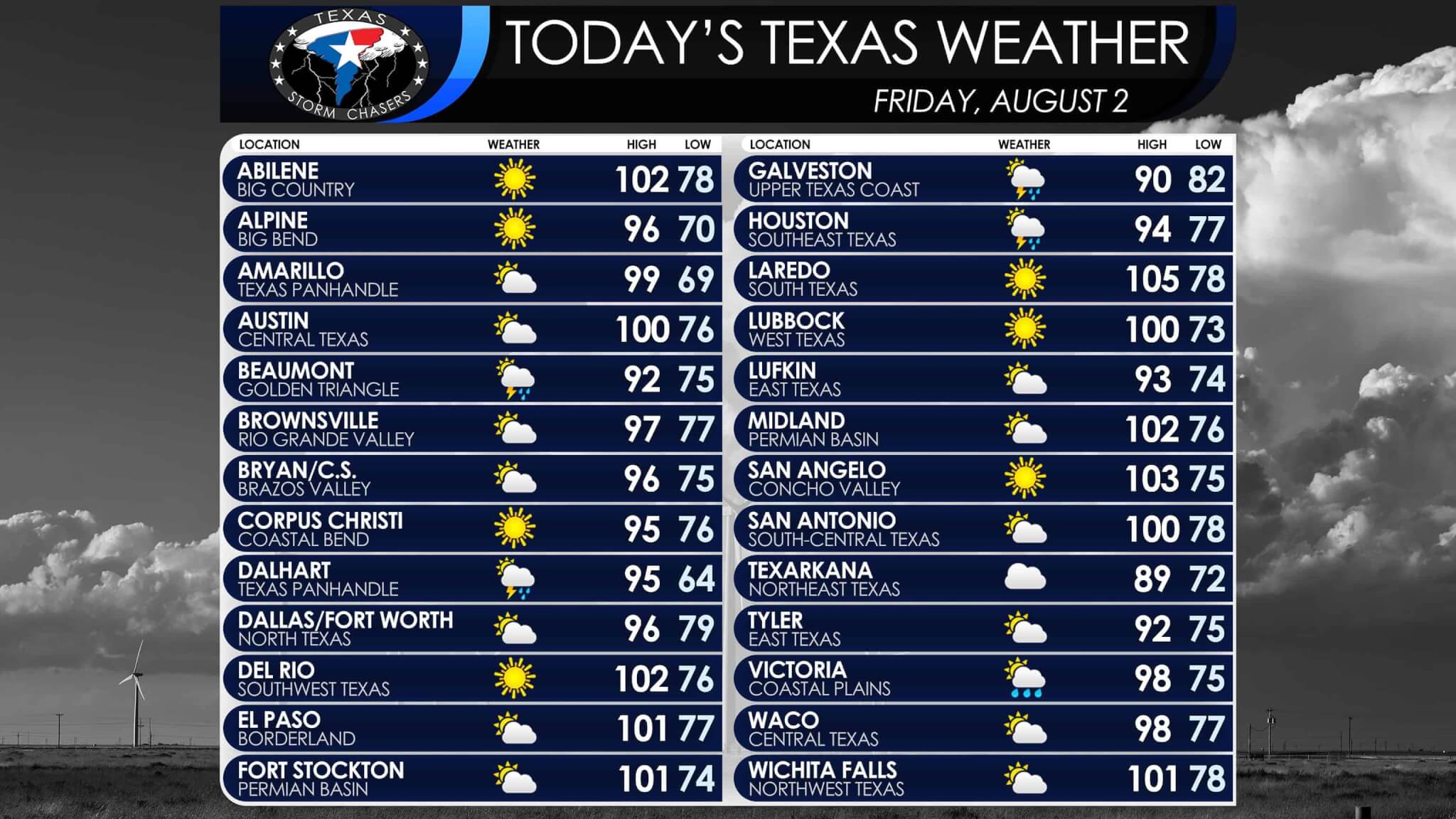
Today will be the typical August toasty for Texas with high temperatures ranging from right around 90 in the Arklatex up past 105 degrees in Laredo. Everyone else will generally be in the 90s to right around 100 degrees. We do note that portions of the Concho Valley, Permian Basin, West Texas, and Northwest Texas could have a few folks make it up toward 105-107 degrees this afternoon. A ‘flash drought’ is quickly developing due to the summer heat and lack of rainfall over the last several weeks. Drying soils are allowing temperatures to climb more easily compared to earlier in the summer when soils were still quite saturated.
Afternoon isolated ‘popcorn’ storms, or showers/storms that pop up and quickly rain themselves out, are expected in Southeast Texas and the Coastal Plains today. Some thunderstorms may also impact the northern half of the Texas Panhandle this evening. Those storms would develop this afternoon in New Mexico and Colorado before moving southeast. Any thunderstorm in Texas during the summer months could become strong with very localized wind gusts over 50 MPH, some small hail, and a quick one to three inches of rain over a very small area. All thunderstorms produce deadly cloud to ground lightning, so if thunder roars go indoors. A few storms may also move across the Red River from Oklahoma tonight into Texoma and North Texas.
Our summer-time upper-level heat dome will be shifting into the Southwestern United States this weekend. That’ll allow for a weak northerly flow aloft and a weak upper-level storm system to move into the eastern half of Texas. The result will be increased cloud cover, temperatures coming down a few degrees, and the possibility of showers and thunderstorms. As stated above the best chance for some folks to get rain this weekend will be across the eastern half of Texas. Especially for those folks along and east of Interstate 35 from Oklahoma City to the D/FW Metroplex to Austin, down into the Brazos Valley, East Texas, Northeast Texas, and Southeast Texas. Not everyone is going to get rain – but at least the increased cloudiness should help it feel a bit less like August. Those who end up under a storm could receive a quick one to three inches of rain if they get lucky. Most folks will see much lower rain amounts (those who get rain at all).
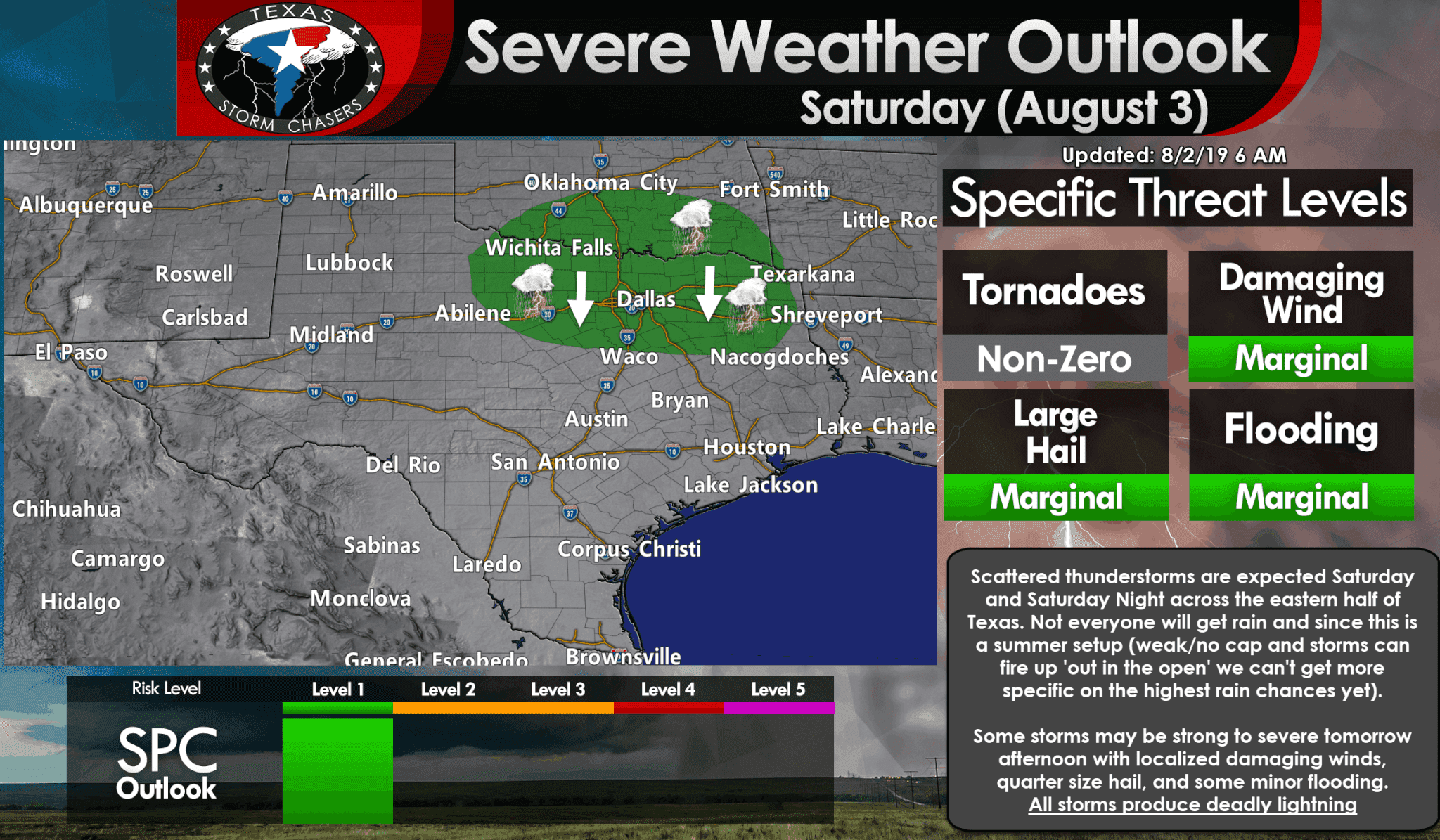
We actually do have an official severe weather risk tomorrow. The Storm Prediction Center has highlighted a level one risk of severe weather for Northwest Texas, the eastern Big Country, all of Texoma, Northwest Texas, northern portions of East Texas, and a majority of North Texas. Some storms may be able to become organized enough tomorrow afternoon and tomorrow evening to produce damaging straight-line winds over 60 MPH along with quarter size hail. With hardly any cap in place, tomorrow’s storm development won’t be particularly predictable too far in advance.
Storms up in Oklahoma tonight will probably push a few outflow boundaries south across the Red River by tomorrow morning. Those boundaries will likely be focal points for scattered thunderstorm development. Realistically we could also see a small cluster of storms try and make its way south across portions of the risk zone tomorrow. If we had a thunderstorm cluster materialize we’d definitely have to watch for some of those stronger outflow winds.
Those heading outdoors tomorrow across the eastern half of Texas should be aware that thunderstorms are possible. All thunderstorms produce dangerous cloud to ground lightning. Erratic outflow winds may occur well away from any thunderstorm. Those erratic winds are of particular concern to those on lakes, and we usually have a few fatalities each summer from those gusty winds you get when an outflow boundary arrives.
Shower and thunderstorm chances will continue on Sunday across the eastern half of Texas, but will generally conclude by Sunday evening. The upper-level heat dome looks like it’ll build back in over Texas next week. Temperatures will likely be back in the upper 90s to 100s with any rain chances confined to the coast and sea breeze activity.
Y’all have a great Friday and remember – when thunder roars go indoors! You can keep tabs on the radar for your area using our interactive radar here on our website and in our free mobile app.


0 Comments