
Good morning and welcome to Hump Day! [Author note: It is actually Thursday, but yours truly can’t keep his days straight anymore. Just pretend for my sake] You just have to survive the day and you’ll be sliding downhill toward the weekend. It’s July in Texas so it’s either going to be hot, stormy and humid (and probably hot) or else we’re going to be dealing with a hurricane. Lousiana will be getting the hurricane and we’ll be getting a rather nice ‘cool’ front.
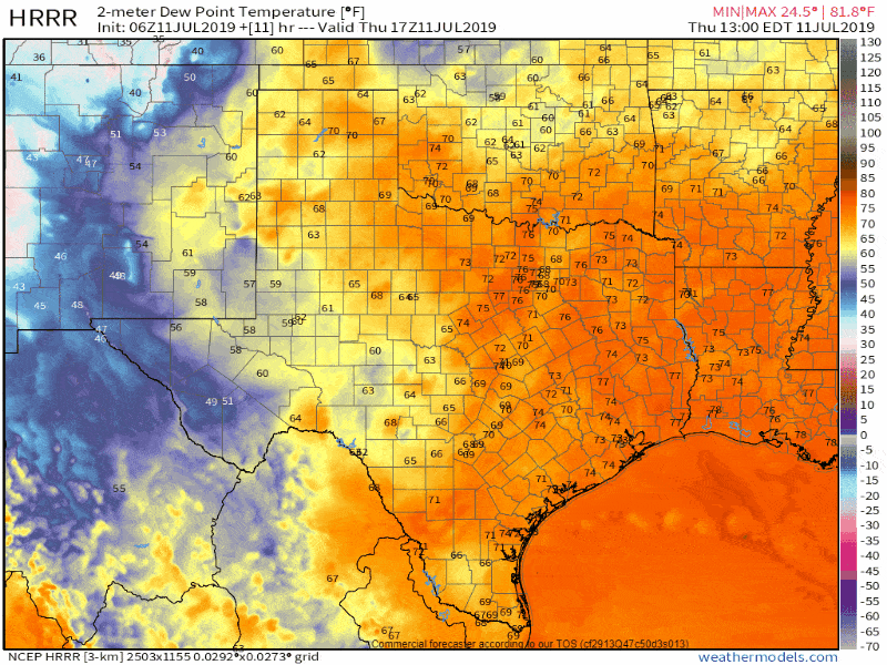
Surface dewpoints lowering behind a summer cool front over the next day
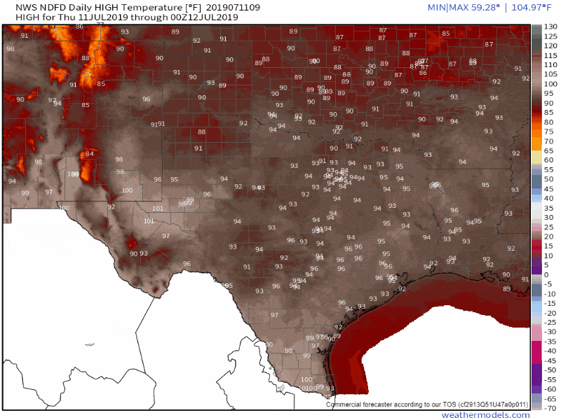
Temperatures aren’t really going to be much cooler, but we are going to see a comparatively drier airmass arrive. That’ll help drop off humidity values and knock the heat index down. Hey, you’ve got take whatever you can get during the summer. If it feels like 95 degrees instead of 105 degrees that’s just fine with me.
Isolated to scattered popup thunderstorms are expected again today, although coverage should be lower across the northern half of Texas compared to yesterday. The threat of organized severe storms is low. However, the stronger storms could produce localized wind gusts over 55 MPH (known as a microburst) along with small hail, heavy rain, and dangerous lightning. Storms won’t be moving very quickly. They’ll generally drift to the south/southwest.
Latest with ‘Barry’
NOAA Hurricane Hunters are currently investigating Invest 92L (also known as Potential Tropical Cyclone #2). It looks like the system is on the verge of becoming a tropical depression. I wouldn’t be surprised if that happens by the time I publish this post. Regardless, it should become Tropical Storm Barry by tonight – and could become a hurricane on Friday. Confidence in a general track is increasing, although some uncertainty naturally remains.
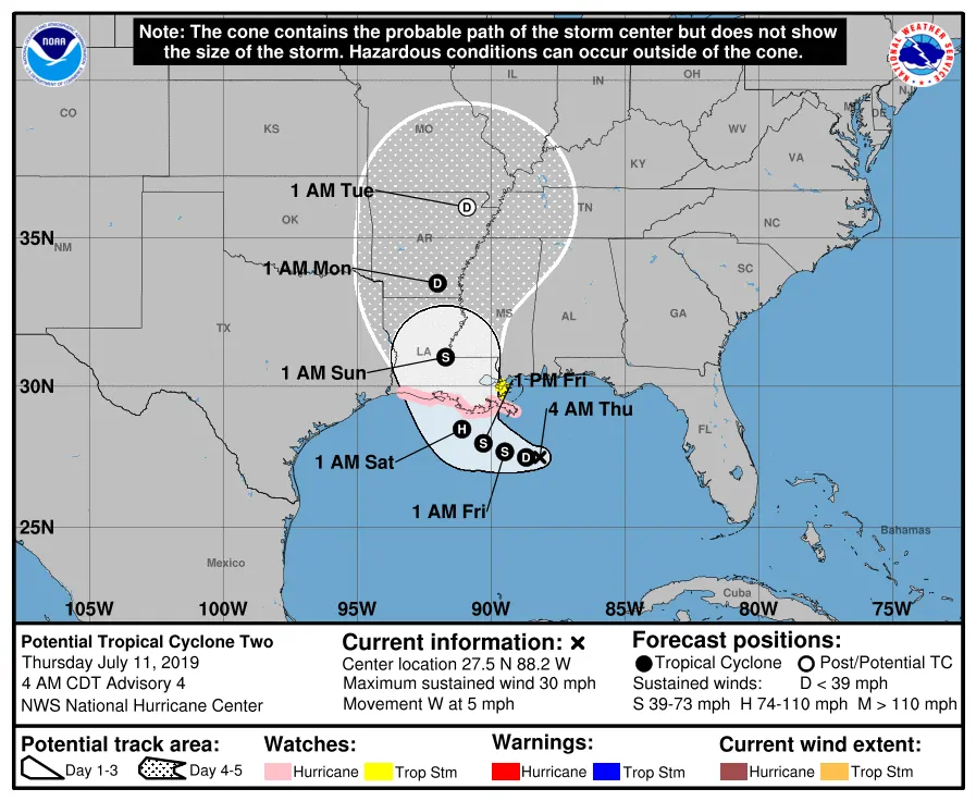 The National Hurricane Center has continued to nudge the forecast track to the east. Confidence continues to increase that landfall will be in Lousiana sometime on Saturday. This system will not be moving quickly at all. Assuming ‘Barry’ does make landfall in Lousiana we in Texas will be on the ‘clean’ side of the system. That means an offshore flow (winds moving out into the Gulf) along with comparatively lower chances of rain. Just how much rain portions of far East Texas could get on Sunday and Monday will depend on how far west the system tracks. If it moves up the Mississippi River we’re not going to see much here in Texas. One reason our confidence is increasing on a non-Texas threat is because of the aforementioned summer cool front moving south today and tonight. That front ‘should’ help nudge Invest 92L/Barry more to the north/northeast (winds are southwesterly ahead of the front).
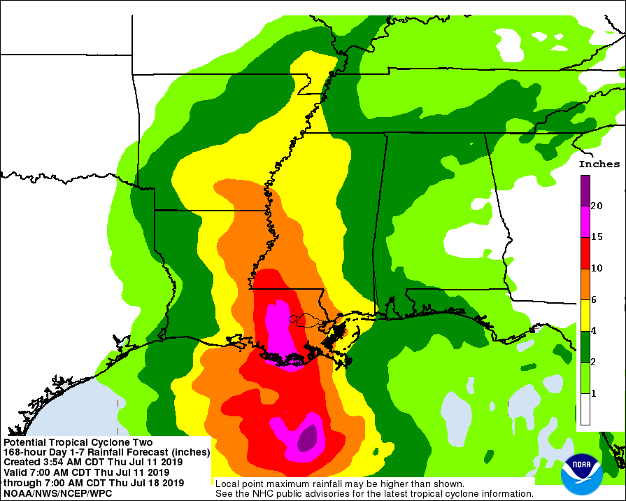
There could be a few showers in far East Texas, but rainfall amounts would remain low. If ‘Barry’ were to track farther west than the rain chances would increase. Lousiana is not going to fare well in the rainfall department with the potential of 15 to 20 inches of rain across Central and Southern Lousiana in the coming days. Coastal storm surge and damaging winds are also expected near and east of the center as the system moves onshore. I believe the heavy inland flooding from rain will become the main story with this system, although a surge pushing up an already high-flowing Mississippi River probably isn’t a good thing either.
While confidence continues to increase that Barry will be a ‘Lousiana’ issue versus one in Texas, we still need to watch data closely. While less likely than the past several days, I cannot rule out a westward jog. If that were to occur we could see the threat for some impacts increase for far Southeast Texas, with heavier rains impacting portions of far East Texas. That’s not in the cards right now, but I’m not going to rule it out either (because Mother Nature likes to laugh at me).
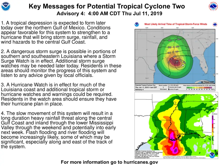
These are key messages regarding future ‘Barry’ from the National Hurricane Center.
More ‘average’ July temperatures into the weekend, but the summer ridge returns next week
High temperature forecast over the next seven days
High temperatures over the next several days are going to be lower than what we’ve seen this past week. While lower is a relative term, temperatures should be back into the seasonal average category. Lower humidity values should help over the next three days, although it’ll still be toasty outside. Hopefully, the overnights will be a tad cooler too. As ‘Barry’ moves inland and moves out of the picture early next week we’ll likely see our upper-level high pressure move back into the region. That’ll help crank up the thermostat and bring back higher dewpoint values. In other words, temperatures will be five to nine degrees warmer next Tuesday and Wednesday compared to Friday-Sunday. Yup, that’s about the amount of excitement we typically have during summer in the weather department (outside of any tropical mischief).


0 Comments