
The National Weather Service in Houston has provided another great forecast discussion regarding Invest 92L – and what will likely become Tropical Storm Barry in the coming days. I doubt I could word their discussion any better, so I’m just going to directly share it below. Some wording may be complex, but overall their discussion conveys the latest forecast summary and forecast changes.
“Amazing what another day of data collection and modeling will do for the forecast. With regards to the potential tropical cyclone formation in the northeast Gulf of Mexico, we still do not know a whole lot more than what we did yesterday but there is an increase in model consensus with the track forecast. So here are a few key points on what we know, what we don`t know and what has changed.
What we know:
- is that an area of low pressure has emerged over the NE Gulf of Mexico. There has been a flare up in convection near this broad area of low pressure but has since seen this convection decrease with more development of convection inland.
- Upper level ridging seems to be taking shape over TX based on water vapor imagery and the lack of convection over TX due to subsidence from the ridge.
- Upper level trough now moving over the northern Plains should continue east tonight.
- Water vapor imagery continues to show at least some vorticity over the NE Gulf and Florida Panhandle. This vorticity seems to be what was coming out of GA and may have combined with vorticity over AL but hard to discern.
- Given a more coherent vorticity center, synoptic models have something more to resolve than before. This has led to 12Z guidance of GFS/ECMWF/CMC having very similar evolutions of the potential tropical cyclone formation and track. There seems to be a growing consensus of models tracking the system towards the Louisiana coast and as far west as the SW Louisiana coast. This still means that there is a chance there could be impacts to SE Texas that need to be monitored. This track has led to lower rain chances over the weekend with most of SE Texas on the drier side of the potential tropical cyclone.
- Track forecast highly dependent upon vertical development of the potential TC and synoptic flow. Keep in mind that as this system organizes boundary layer flow up to about 700-500mb will determine steering of the system while a more developed system will be influenced by deeper layered flow say 700-200mb flow. As this system organizes, the center could very well re-located based off deepest convection until an inner core develops. Again this will influence the track.
What we still don`t know:
- Upper level ridge does form over the southern Rockies for the end of the week but just how strong will it be?
- Current upper level trough over the northern Plains dips down into the Great Lakes and Ohio River Valley. Will this trough be enough to cause a strong enough weakness in the flow for the system to move north into Louisiana as the models suggest? Could the trough move just far enough north that it has less of an influence on the track and the potential TC tracks more towards
the Texas coast. - Intensity forecast – good question. Conditions favorable for rapid development given warm Gulf waters and little shear. Shear may increase over the weekend as the system supposedly moves north into Louisiana. Again several question marks still on the system`s organization.
Changes since yesterday:
- Biggest change is the models latching on to the vorticity better and having more consensus with the track into Louisiana.
- That said, still leary of the track forecast since it depends upon a ridge that is yet to fully develop, a trough that is still tracking a decent distance from the Gulf and may not have as much influence on the track and still hinges upon a tropical cyclone developing which has not happened yet.
With all this in mind, we are still not truly able to brief impacts or fully discuss what they may be. Rainfall forecast has changed since yesterday due to a different track of the system but that could change again. Track and intensity forecast impact the wind forecast impacts and storm surge. Another 12-24 hrs of data collection and evolution in the models will go a long way in nailing down more of these details for decision making. Main point, stay on top of NHC outlook updates and make sure your preparedness plans are ready to go. We still may go from not sure about impacts to very high impacts in a short amount of time.”
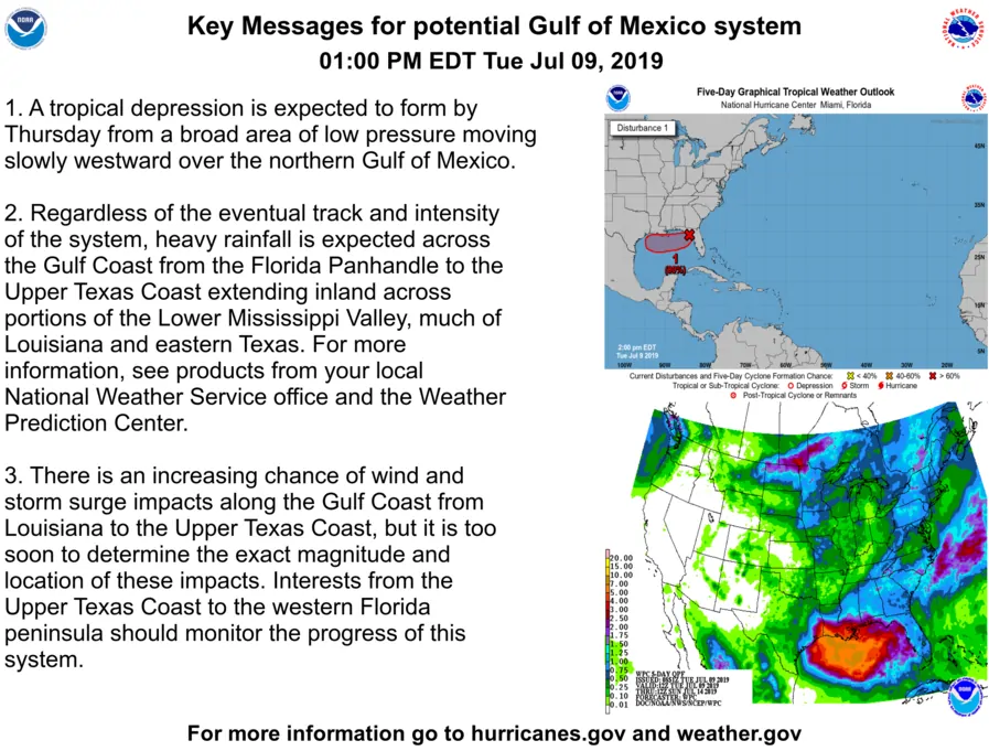
That was an excellent discussion indeed from meteorologist Scott Overpeck at the National Weather Service office in Houston. So while we still do not have a ‘defined’ system, it is a bit better organized than it was yesterday. The National Hurricane Center indicates a high probability of development over the next two days. Specifically, we’ll be watching Wednesday Night into Thursday for more organization to develop. Once that occurs this system will probably become Tropical Storm Barry. Most weather models do have this system becoming a tropical storm, so confidence is increasing we will have a ‘named’ system by Thursday or Friday. NOAA and the USAF will both have aircraft out in the Gulf beginning tomorrow.
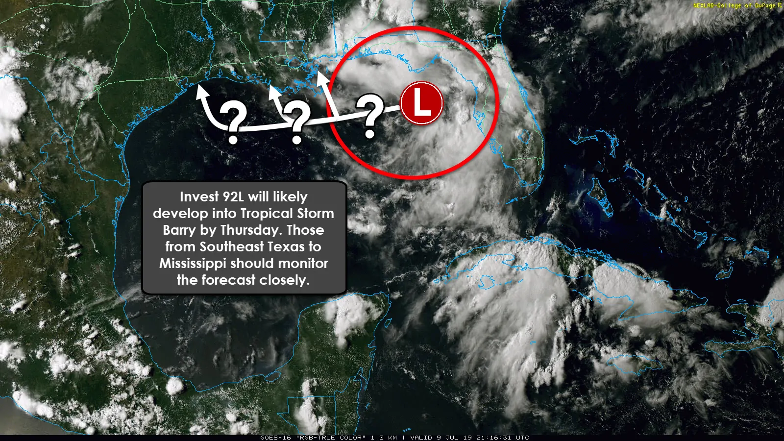
While weather models have generally shifted more east compared to yesterday, I really must caution folks that shifts are not uncommon. Until we have a well-defined ‘center’ generate weather models are still ‘guessing’ on not only the eventual path of this system but the ‘center’s location’ too. If the system ends up forming 40 miles farther west, that could result in a 150-200 mile shift west in the eventual landfall point. That being said – today’s trends have been positive for Texas, but not great for Lousiana. Don’t go canceling your plans just yet – but I encourage those from the Upper Texas Coast (Southeast Texas) east into Lousiana to stay on top of the forecast. You may need to adjust those plans depending on what data shows tomorrow.
In terms of a landfall intensity on Friday or Saturday – this system will probably be at least tropical storm strength. However, if it overachieves, it could try to make it up to hurricane status. That would result in some storm surge and coastal wind impacts. However, big-time inland rains are going to be a significant issue regardless of the storm’s eventual intensity. Major flooding seems likely along and east of the storm’s eventual track. West of the track? There could be some rain chances, but overall there is a reason they call it the ‘clean’ side of the storm.
If ‘Barry’ moves into Lousiana we in Texas would likely remain hot and humid. If the system moves farther west and into Texas, the chance of significant rainfall would dramatically increase along and east of the system’s track. We’ll have a much better idea on how this will evolve tomorrow evening and especially by Thursday. As Scott’s detailed discussion above stated – we also have uncertainties about the strength of certain upper-level features. Even subtle changes in those upper-level features could result in changes in the eventual track. This system is going to be a slow-mover.


0 Comments