
A relatively localized severe weather event is expected to unfold this afternoon. While the real estate of today’s threat may not be overly high, there is the potential for impactful severe thunderstorms across South-Central Texas shortly after lunchtime. Those storms would move southeast into the Coastal Bend and Coastal Plains by the late afternoon. From there those storms would move off the coast and into the Gulf of Mexico. Let’s dive into it.
Click the image for a full-screen version.
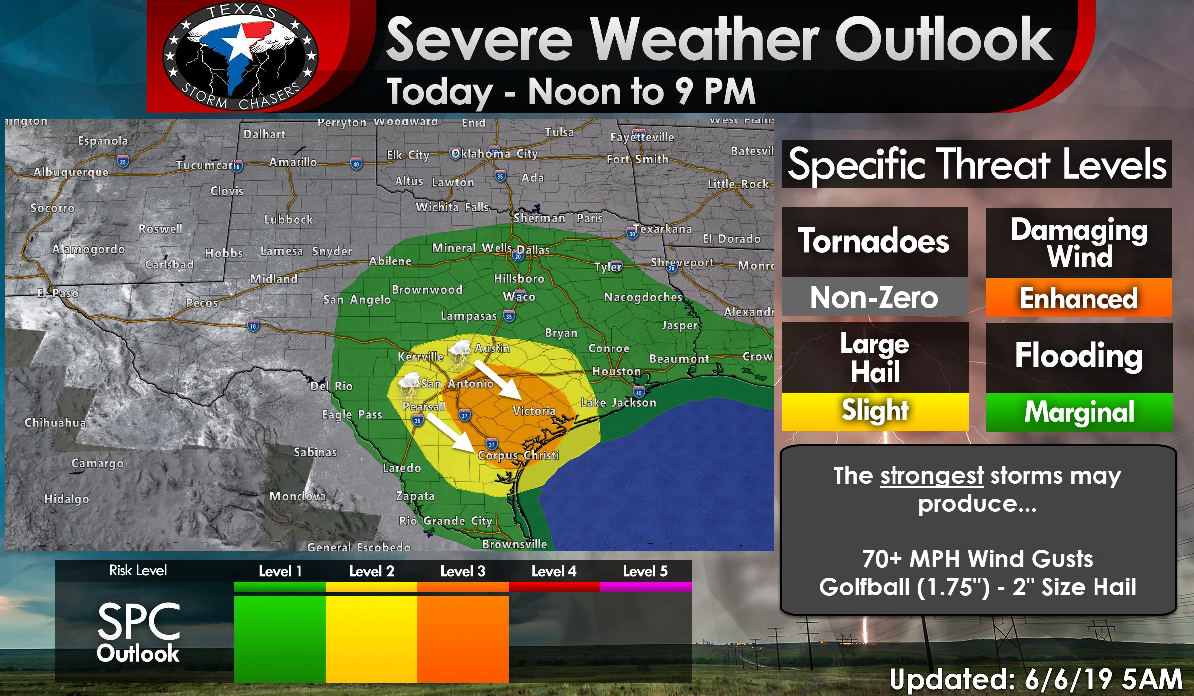
A level three risk of severe weather continues for portions of South-Central Texas extending southeast into the Coastal Bend. San Antonio, New Braunfels, Pleasanton, Gonzales, Cuero, Beeville, Corpus Christi, Rockport, Victoria, and Port Lavaca are a few towns included. This relatively small enhanced risk is where confidence is highest in several severe thunderstorms occurring this afternoon. Specifically, a line or cluster of severe thunderstorms moving southeast. A level three risk means there is a 30% chance of severe weather occurring within 25 miles of your location. That means quarter size hail or larger and/or wind gusts over 58 MPH. While a tornado cannot be ruled out, the overall tornado threat is very zero to non-zero today. Frequent to downright constant to ground lightning will be common with storms today. Those with outdoor plans should have a nearby self shelter ready if storms approach. When thunder roars go indoors!
The storms that moved through earlier this morning should not impact available instability for storms this afternoon. That’s assuming we don’t have residual cloud cover or rain remain in the aforementioned risk zones. Those storms probably left a few outflow boundaries that’ll be focal points for new storm development shortly after lunchtime. A weak cap and plenty of morning sunshine should result in thunderstorm development by the late morning or early afternoon around or not far west of Interstate 35 in South-Central Texas. Once storms develop they could quickly intensify and become severe with a threat of large hail. That threat includes the San Antonio metro. It may be *just* south of Austin proper, but it’ll be close. Storm movement will be to the east/southeast. If storms form a bit farther north that would ‘shift’ the severe weather chances farther north toward the Brazos Valley and Southeast Texas later in the day.
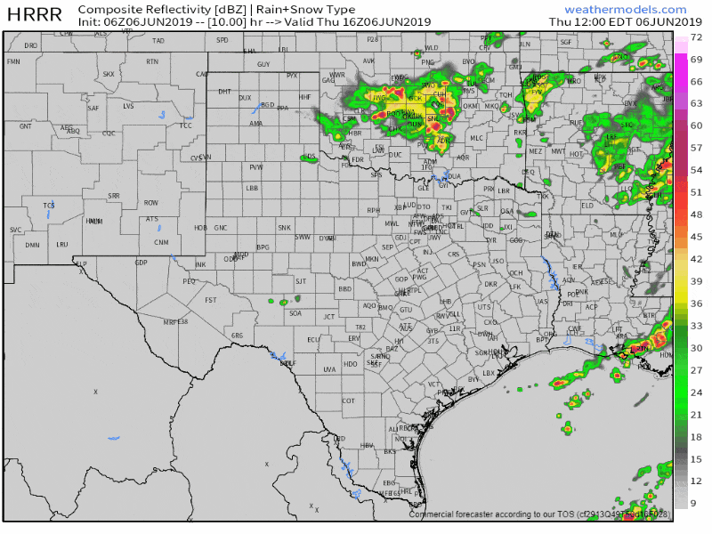
Simulated weather model radar from 11 AM to 9 PM today. Exactly where the first storms develop and organize will dictate the downstream threat from a cluster/line of storms. This model will not be able to pin that down exactly, so expect some variation in the actual event later today. Use this as a general timeline guide, not a “is it going to be over my backyard at exactly 252PM” sort of deal.
I don’t believe it’ll take more than an hour or two before storms congeal into a cluster or small squall line. Once that upscale growth occurs the threat for damaging straight-line winds is expected to significantly increase. The strongest storms in the line could produce wind gusts over 70 MPH. As the cluster of storms becomes more organized it’ll take a turn from east/southeast to more of a southeasterly direction. That’ll have the cluster moving into the Coastal Bend and portions of the Coastal Plains by the middle to late afternoon hours. Some storms will be severe with damaging winds and hail. Our threat of severe weather will conclude when the storms move off the coast and into the Gulf of Mexico. That could happen as soon as 7 or 8 PM, or perhaps a bit closer to 10 PM.
More isolated/scattered thunderstorm activity may occur across other regions of Texas today. Those storms, at least the more potent ones, could produce some hail and gusty winds – as is typical with summertime activity. Those should not be as organized as the cluster of storms expected in South-Central Texas.
You can keep tabs on the storms as they get going this afternoon with our free HD interactive weather radar here on our website or in our free mobile app (link at the top of this page).


0 Comments