
Precipitation across the eastern half of Texas today was driven by a storm system just off the Southeast Texas coast. In combination with abundantly high moisture values, those showers/storms produced quite a bit of rainfall in a short period of time. Wind shear values were low, so storms weren’t too much of a severe weather threat. We did have to deal with a few tornado warnings for waterspouts coming on-shore and brief rotation just inland. However, I haven’t heard of any damage. Storms ongoing in western portions of Texas are occurring in somewhat higher wind shear values (still modest). Those storms grew upscale into a squall line and have been producing one heck of a dust storm. That’ll continue moving east into West-Central and Northwest Texas this evening while slowly weakening.
A quick-moving but rather impressive (for June) upper-level storm system will move across the Hill Country, Central Texas, South Texas, and Southeast Texas tomorrow afternoon. That will serve to increase wind shear values aloft – an important factor in storm organization. Winds aloft help blow rain away from an updraft – allowing that updraft to continue ingesting warm, unstable air. It’s June and a lack of instability will not be an issue tomorrow. So once storms get going in the early afternoon they’ll probably get going in a hurry.
Click the image for a full-screen version.
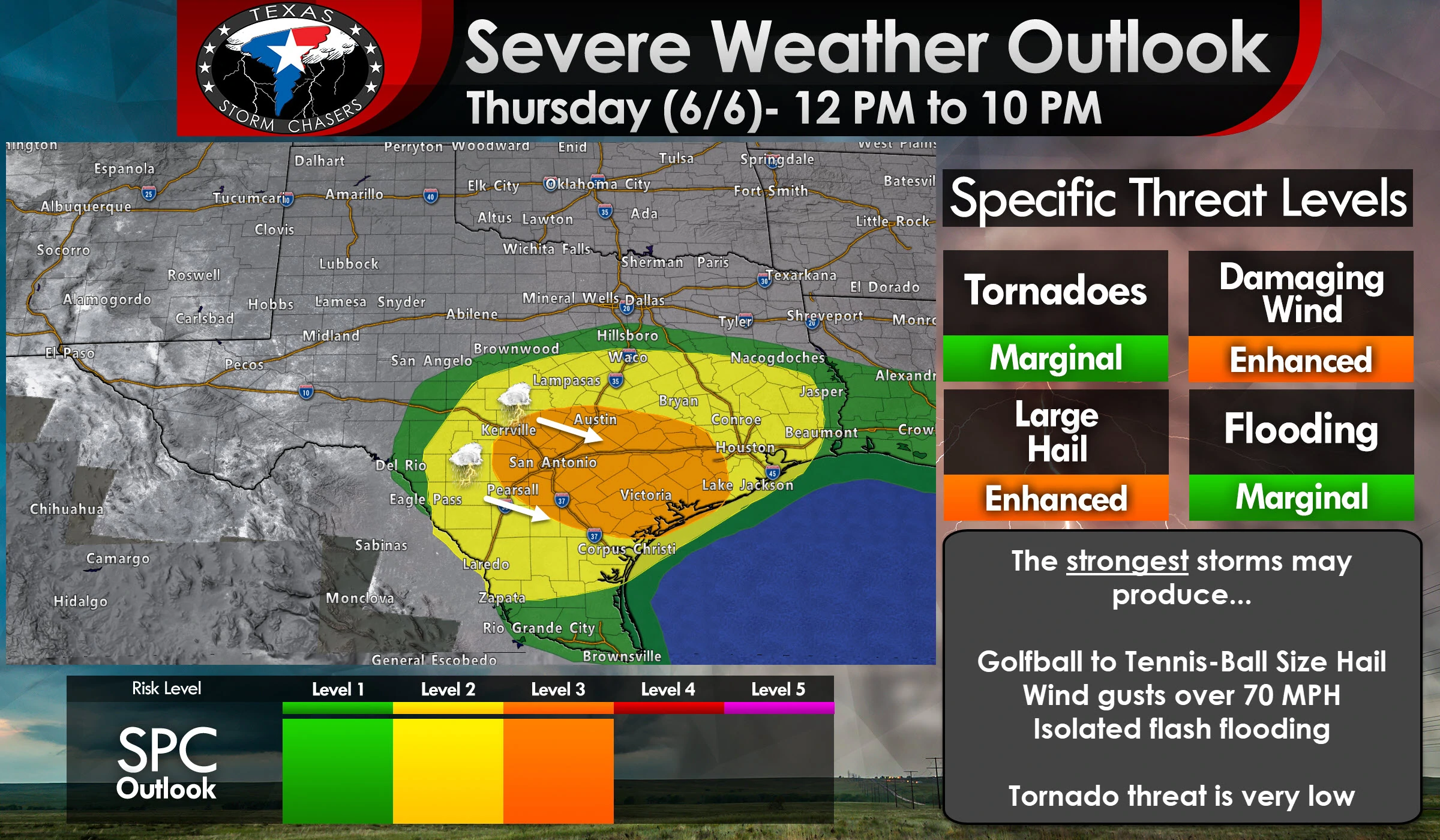
The combination of a seasonably strong upper-level storm system (lift), plenty of moisture, and a strongly unstable airmass will support severe thunderstorms tomorrow afternoon.
A level three risk of severe weather includes portions of the Hill Country, South-Central Texas, extending southeast into the Coastal Plains. Austin, San Marcos, San Antonio, Pleasanton, Beeville, Victoria, Yoakum, Wharton, Sealy, and Brenham are a few towns included. A level three risk means a 30% chance of severe weather occurring within 25 miles of any given point (like your home).
Surrounding the enhanced risk zone we’ve got the standard level two risk. That level two risk includes South Texas, more of the Hill Country, the Brazos Valley, and more of Southeast Texas. Brady, Uvalde, Laredo, Zapata, Falfurrias, Corpus Christi, Galveston, Houston, Conroe, Bryan, Killeen, Waco, Livingston, and Lufkin are a few towns included. That risk zone will have a 15% chance of severe weather within 25 miles of any given point (like your home).
Finally, the marginal level one risk surrounds the higher risk zones. It primarily includes the Rio Grande Valley.
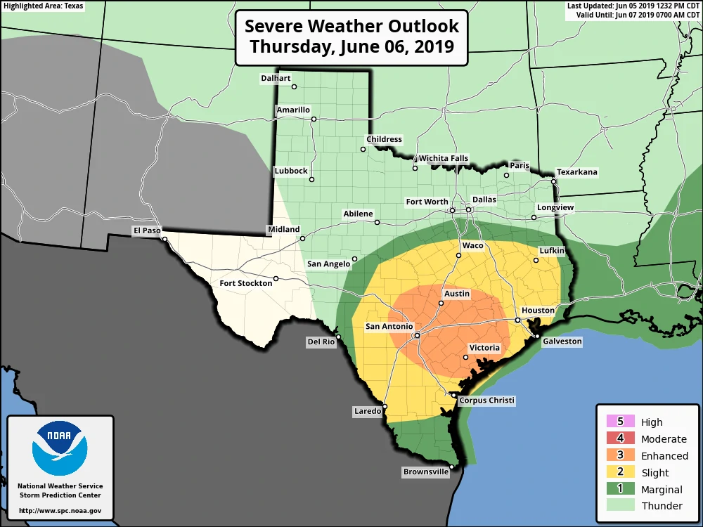
The same severe weather outlook for tomorrow, but larger. You can click the image for a full-screen version.
Exactly where the lines are drawn will change with future outlooks. Please don’t pay too much attention to where the risk zones are drawn. If you’re in OR near any risk pay attention. Storms don’t abide by our outlooks. They’re just that, an outlook.
Tomorrow isn’t a ‘tornado’ day. Low-level wind shear will be extremely weak. The risk for tornadoes isn’t zero though. Residual outflow boundaries from today’s storms along with the very unstable airmass expected tomorrow could allow an isolated tornado.
Large hail and damaging straight-line winds are more likely with the most intense storms. Storms exhibiting supercelluar characteristics could produce very large hail up to the size of tennis balls.
Getting wind gusts of 60 to 70 MPH won’t be very difficult tomorrow thanks to all that instability and heavy rain-loading (wet microbursts). Once storms grow upscale into a squall line we may see an enhanced damaging wind threat develop – with some winds probably exceeding 70 MPH. Both of those threats will make a mess out of your day if they impact you.
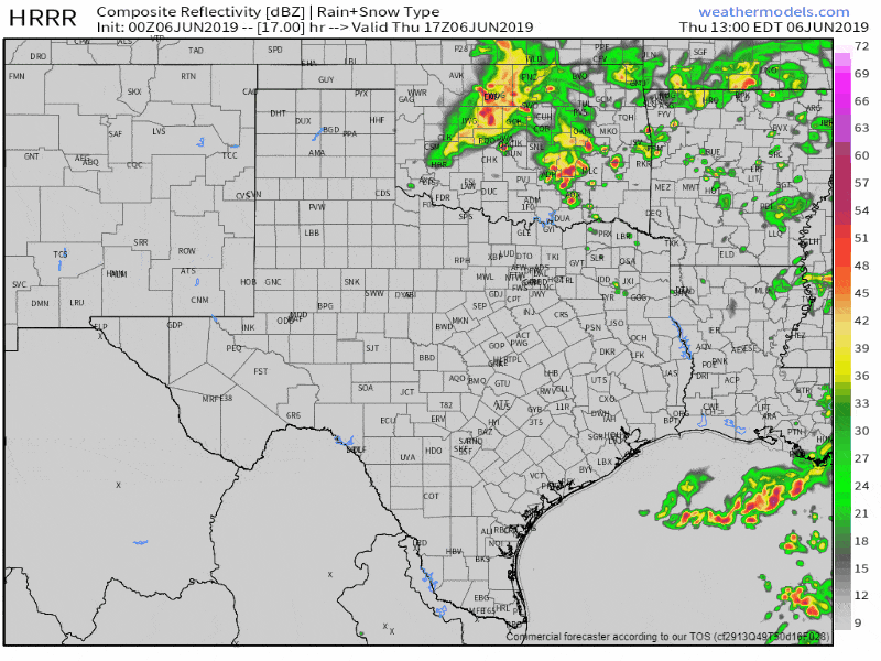
Simulated weather model radar from 12 PM to 10 PM Thursday. This is a simulation and will likely change somewhat by the time we get into the day. Click the image for a full-screen version.
The first storms will probably begin developing around noon not too far west of Interstate 35 in Central/South-Central Texas. Storms could intensify quickly with a threat of large hail and localized damaging wind gusts. These initial storms will have the best chance of producing very large hail. Not great news since they’ll be firing up near large population centers. Storms will move off to the east/southeast and begin growing upscale into a squall line.
It may not take too long for storms to become clustered or form into a line. Once that happens storms may begin moving east/southeast more quickly toward the Coastal Plains and western Southeast Texas. We’ll also see an increasing damaging wind risk, although I’d bet on large hail continuing too. These storms will be moving at a decent clip so the threat of flooding shouldn’t become too significant. Isolated flash flooding will be possible, but it shouldn’t become a widespread concern.
The threat of severe weather will end tomorrow evening once the cluster of thunderstorms moves off the coast. Moderate rainfall may continue for an hour or two after the initial line’s passage, but the threat of severe weather will have ended.


0 Comments