
Good morning and happy hump-day! You’ve made it to Wednesday and can start the descent toward the weekend. Well, at least those who work a typical work week. Today is Friday for Paige so to each their own. Anyway, the radar is lit up this morning with showers in several portions of Texas. The heaviest rains are impacting just west of Port Arthur to the Houston metro all the way down the coast into the Coastal Bend and Corpus Christi.
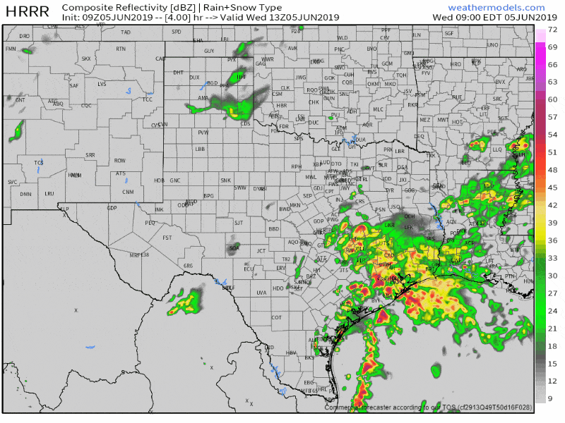
Simulated weather model radar from 8 AM through 9 PM today. This is only one model’s simulation of how the radar may look throughout the day. Remember that this isn’t actually a real radar. Click the image for a full-size version.
A very localized, but potentially significant heavy rain event is expected along the immediate Southeast Texas coast today. Specifically, Freeport to Galveston to Port Arthur could get walloped by heavy rain. Short-term high-resolution weather models, which are run hourly, have been very persistent in dropping over a foot of rain in part of Galveston County this afternoon. This may end up being similar to a previous event earlier this spring where most of Houston (Harris County) was wet, while Galveston was dealing with major flooding. I can’t rule out that band of very high rain totals setting up a bit farther north or south – but someone is probably going to have to deal with way too much rain today. If we get lucky that’ll all fall just offshore where the only impacts will be to vessels and the fishies. Localized heavy rainfall (totals over 5 inches) may occur farther inland in Southeast Texas today. Extremely high moisture values will promote rainfall rates of 3 to 5 inches per hour with the strongest activity. That kind of rain in such a short period will cause flash flooding regardless of if its in a cow pasture or in the middle of Harris County.
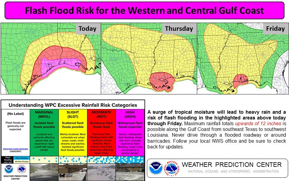
Click the image for a full-screen version.
That said the Weather Prediction Center has issued a high risk of flash flooding along the immediate Southeast Texas coast for today. A high risk for flash flooding is just as serious as a high risk of severe weather. Both are rare and should be taken very seriously. Shower and thunderstorm coverage will be scattered across the eastern half of Texas today. Some folks may get several inches of rain while others right down the road get sprinkles. It also won’t rain the entire day for most folks. Excluding the fact that rain/storm coverage will be higher than a typical summer afternoon, the ‘storm mode’ generally will be the ‘popcorn’ variety. It goes up, makes some noise and drops a bunch of rain for 45 minutes, drops outflow and weakens.
A level one risk of severe weather coverages the western half of Texas this afternoon into tonight. Just like the last several days, we’ll see scattered thunderstorms fire up east of a dryline and on residual outflow boundaries this afternoon. Those storms will slowly move east/northeast. The strongest storms could produce large hail and localized damaging winds. They may grow upscale into a line or cluster this evening. If that occurs they’ll make a run at the Concho Valley and Big Country with some gusty winds. Our focus for a more organized severe weather threat will be for Thursday.
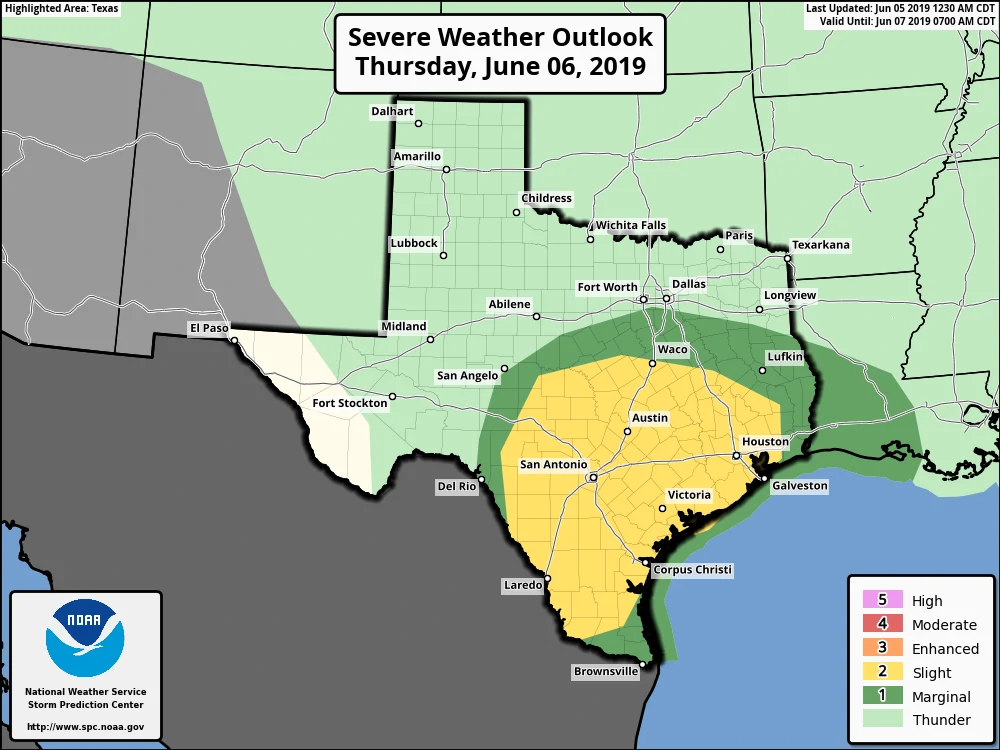
Severe weather outlook for Thursday. Click the image for a full-screen version.
We’ve got a level two risk of severe weather across South Texas, South-Central Texas, the Hill Country, Central Texas, the Brazos Valley, Southeast Texas, and the Coastal Plains. An upper-level low will be passing overhead tomorrow. That’ll ramp up wind shear aloft – and the ‘summer’ atmosphere in place isn’t going anywhere. That means we’re going to have a LOT of instability to work within the atmosphere. Lots of instability plus wind shear aloft means we’ll be looking at much more organized thunderstorms compared to today. The strongest storms tomorrow afternoon could produce very large hail and damaging straight-line winds. Low-level wind shear will be weak and that’ll keep the tornado threat very low. It won’t be zero because of residual outflow boundaries and plenty of instability. Tomorrow’s a hail/wind day versus a tornado day. Of course, if there is one tornado tomorrow and it comes down your street it most certainly will become a ‘big tornado day’ for you. We’ll deal with tomorrow’s severe weather threat in more detail once we get through this morning and afternoon.
All the weather ruckus moves out on Friday and we will quickly transition into our first ‘nasty’ heatwave of the summer. Ridging aloft will greatly reduce rain chances and crank up the thermostat. High temperatures won’t get too out of hand, but with all the soil moisture the humidity is going to enter the annoyingly nasty category. Heat index values of 105 to 110+ degrees are expected this weekend across the eastern two-thirds of Texas. It’s been pretty wet across western portions of Texas this spring too – so the humidity will probably be more obnoxious than usual out there too.


0 Comments